List of listed buildings in Bothwell, South Lanarkshire
This is a list of listed buildings in the parish of Bothwell (also including Uddingston) in South Lanarkshire, Scotland.
Map all coordinates using OpenStreetMap
Download coordinates as:
- KML
- GPX (all coordinates)
- GPX (primary coordinates)
- GPX (secondary coordinates)
List
| Name | Location | Date Listed | Grid Ref. [note 1] | Geo-coordinates | Notes | LB Number [note 2] | Image |
|---|---|---|---|---|---|---|---|
| Bothwell, 29 Hamilton Road/ 1 Old Mill Road, Including Gatepiers And Boundary Walls | 55°48′00″N 4°03′53″W / 55.799902°N 4.064692°W / 55.799902; -4.064692 (Bothwell, 29 Hamilton Road/ 1 Old Mill Road, Including Gatepiers And Boundary Walls) | Category B | 45074 |  Upload Photo | |||
| Bothwell, 6 Manse Avenue | 55°48′21″N 4°04′14″W / 55.805951°N 4.070549°W / 55.805951; -4.070549 (Bothwell, 6 Manse Avenue) | Category C(S) | 45078 | Upload Photo | |||
| Bothwell, 4 And 4A Mill Road, Including Gatepiers And Boundary Walls | 55°48′05″N 4°04′17″W / 55.80145°N 4.071507°W / 55.80145; -4.071507 (Bothwell, 4 And 4A Mill Road, Including Gatepiers And Boundary Walls) | Category B | 45084 | Upload Photo | |||
| Uddingston, 20 Douglas Gardens, Including Gatepiers, Boundary Walls And Summerhouse | 55°48′57″N 4°04′39″W / 55.815808°N 4.077569°W / 55.815808; -4.077569 (Uddingston, 20 Douglas Gardens, Including Gatepiers, Boundary Walls And Summerhouse) | Category B | 45097 | Upload Photo | |||
| Uddingston, 1-9 Old Glasgow Road, (Odd Nos), (Incorporating Police Station) Including Gatepiers, Boundary Walls And Railings | 55°49′02″N 4°04′56″W / 55.817266°N 4.082228°W / 55.817266; -4.082228 (Uddingston, 1-9 Old Glasgow Road, (Odd Nos), (Incorporating Police Station) Including Gatepiers, Boundary Walls And Railings) | Category C(S) | 45103 | Upload Photo | |||
| Uddingston, Watson Street, Muiredge Primary School, Including Boundary Walls, Gatepiers, Railings And Headmaster's House | 55°49′14″N 4°04′36″W / 55.82049°N 4.076542°W / 55.82049; -4.076542 (Uddingston, Watson Street, Muiredge Primary School, Including Boundary Walls, Gatepiers, Railings And Headmaster's House) | Category B | 45105 | Upload Photo | |||
| Uddingston, 2, 6 And 8 Old Glasgow Road | 55°49′06″N 4°04′57″W / 55.818277°N 4.082522°W / 55.818277; -4.082522 (Uddingston, 2, 6 And 8 Old Glasgow Road) | Category C(S) | 6622 | Upload Photo | |||
| Bothwell, Main Street, St Bride's Collegiate Church, (Church Of Scotland), Including Graveyard, Boundary Walls, Gatepiers And Gates | 55°48′12″N 4°04′03″W / 55.803371°N 4.067365°W / 55.803371; -4.067365 (Bothwell, Main Street, St Bride's Collegiate Church, (Church Of Scotland), Including Graveyard, Boundary Walls, Gatepiers And Gates) | Category A | 5134 |  Upload another image | |||
| Bothwell, Bothwell Bridge | 55°47′45″N 4°03′29″W / 55.795926°N 4.057988°W / 55.795926; -4.057988 (Bothwell, Bothwell Bridge) | Category A | 5138 | 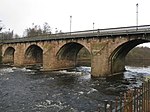 Upload another image | |||
| Bothwell, Blantyre Mill Road, Elmwood Lodge | 55°48′10″N 4°04′28″W / 55.802694°N 4.074509°W / 55.802694; -4.074509 (Bothwell, Blantyre Mill Road, Elmwood Lodge) | Category C(S) | 5144 | Upload Photo | |||
| Uddingston, 64-66 Old Glasgow Road, (Even Nos), Including Outbuilding | 55°49′12″N 4°05′09″W / 55.819937°N 4.085851°W / 55.819937; -4.085851 (Uddingston, 64-66 Old Glasgow Road, (Even Nos), Including Outbuilding) | Category B | 5148 | Upload Photo | |||
| Uddingston, Greyfriars Road, Greyfriars Including Gatepiers, Quadrant Walls And Walled Garden | 55°49′57″N 4°06′29″W / 55.83247°N 4.108191°W / 55.83247; -4.108191 (Uddingston, Greyfriars Road, Greyfriars Including Gatepiers, Quadrant Walls And Walled Garden) | Category B | 5150 | Upload Photo | |||
| Bothwell, 13A And 13B Blantyre Mill Road Including Gatepiers And Boundary Walls | 55°48′08″N 4°04′19″W / 55.802325°N 4.071841°W / 55.802325; -4.071841 (Bothwell, 13A And 13B Blantyre Mill Road Including Gatepiers And Boundary Walls) | Category C(S) | 45071 | Upload Photo | |||
| Bothwell, 27 Hamilton Road, The Cricklewood, Public House, Including Boundary Walls | 55°47′59″N 4°03′52″W / 55.79961°N 4.064453°W / 55.79961; -4.064453 (Bothwell, 27 Hamilton Road, The Cricklewood, Public House, Including Boundary Walls) | Category C(S) | 45073 | Upload Photo | |||
| Bothwell, 6 Orchard Avenue, (Formerly 8 Hamilton Road), Including Gatepiers And Boundary Walls | 55°47′57″N 4°03′47″W / 55.799059°N 4.06302°W / 55.799059; -4.06302 (Bothwell, 6 Orchard Avenue, (Formerly 8 Hamilton Road), Including Gatepiers And Boundary Walls) | Category C(S) | 45076 | Upload Photo | |||
| Uddingston, 21 Glasgow Road, Including Gatepiers And Boundary Walls And Outbuilding To Rear | 55°49′37″N 4°05′21″W / 55.826812°N 4.089045°W / 55.826812; -4.089045 (Uddingston, 21 Glasgow Road, Including Gatepiers And Boundary Walls And Outbuilding To Rear) | Category C(S) | 45099 | Upload Photo | |||
| Bothwell, Old Bothwell Road, Covenanters Memorial Including Boundary Walls And Railings | 55°47′48″N 4°03′30″W / 55.796557°N 4.058373°W / 55.796557; -4.058373 (Bothwell, Old Bothwell Road, Covenanters Memorial Including Boundary Walls And Railings) | Category B | 5139 | 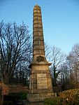 Upload another image | |||
| Bothwell, Hamilton Road, Old Bothwell Primary School, Including Detached Dining Hall, Gatepiers, Boundary Walls And Railings | 55°48′07″N 4°03′54″W / 55.802025°N 4.065092°W / 55.802025; -4.065092 (Bothwell, Hamilton Road, Old Bothwell Primary School, Including Detached Dining Hall, Gatepiers, Boundary Walls And Railings) | Category B | 5154 | Upload Photo | |||
| Bothwell, 4 Hamilton Road, Including Boundary Walls | 55°47′56″N 4°03′44″W / 55.798867°N 4.0621°W / 55.798867; -4.0621 (Bothwell, 4 Hamilton Road, Including Boundary Walls) | Category C(S) | 45075 | Upload Photo | |||
| Bothwell, 46 Main Street, St Bride's Church Lodge | 55°48′12″N 4°04′07″W / 55.803241°N 4.068714°W / 55.803241; -4.068714 (Bothwell, 46 Main Street, St Bride's Church Lodge) | Category B | 45081 | Upload Photo | |||
| Bothwell, 28 Silverwells Crescent, Douglas Lodge, Including Boundary Walls And Gatepiers | 55°47′58″N 4°04′22″W / 55.799569°N 4.072763°W / 55.799569; -4.072763 (Bothwell, 28 Silverwells Crescent, Douglas Lodge, Including Boundary Walls And Gatepiers) | Category C(S) | 45090 | Upload Photo | |||
| Uddingston, 2 Holmwood Avenue Including Gatepiers And Boundary Walls And Outbuilding | 55°49′30″N 4°04′54″W / 55.825024°N 4.081605°W / 55.825024; -4.081605 (Uddingston, 2 Holmwood Avenue Including Gatepiers And Boundary Walls And Outbuilding) | Category C(S) | 45100 | Upload Photo | |||
| Uddingston, 7-25 (Odd Nos), Main Street And 4 Bellshill Road, Royal Buildings | 55°49′05″N 4°04′56″W / 55.817933°N 4.082104°W / 55.817933; -4.082104 (Uddingston, 7-25 (Odd Nos), Main Street And 4 Bellshill Road, Royal Buildings) | Category B | 6621 | Upload Photo | |||
| Bothwell, 24 Fairfield Place, Fairfield House, Including Boundary Walls And Gatepiers, Garden Walls, Gatepiers And Gates | 55°48′14″N 4°03′46″W / 55.803854°N 4.062715°W / 55.803854; -4.062715 (Bothwell, 24 Fairfield Place, Fairfield House, Including Boundary Walls And Gatepiers, Garden Walls, Gatepiers And Gates) | Category B | 5142 | Upload Photo | |||
| Bothwell, 2 Main Street, Library, Formerly The Donald Institute, Including Boundary Walls, Gatepiers, Gates And Railings | 55°48′08″N 4°03′57″W / 55.802204°N 4.065707°W / 55.802204; -4.065707 (Bothwell, 2 Main Street, Library, Formerly The Donald Institute, Including Boundary Walls, Gatepiers, Gates And Railings) | Category C(S) | 5155 | Upload Photo | |||
| Bothwell, 15-17 (Odd Nos) Langside Road, Including Boundary Wall And Gatepiers | 55°48′00″N 4°03′45″W / 55.800072°N 4.062611°W / 55.800072; -4.062611 (Bothwell, 15-17 (Odd Nos) Langside Road, Including Boundary Wall And Gatepiers) | Category C(S) | 45077 | Upload Photo | |||
| Bothwell, 11 Silverwells Crescent, Hollybank, Including Boundary Walls And Gatepiers | 55°48′01″N 4°04′00″W / 55.800166°N 4.06662°W / 55.800166; -4.06662 (Bothwell, 11 Silverwells Crescent, Hollybank, Including Boundary Walls And Gatepiers) | Category C(S) | 45087 | Upload Photo | |||
| Uddingston Bowling And Tennis Club, Central Block Of Clubhouse Only | 55°49′07″N 4°05′06″W / 55.818619°N 4.08511°W / 55.818619; -4.08511 (Uddingston Bowling And Tennis Club, Central Block Of Clubhouse Only) | Category C(S) | 45095 | Upload Photo | |||
| Uddingston, Bothwell Road, Bothwell Castle Gatehouse Including Screen Walls, Quadrant Walls And Piers | 55°48′46″N 4°04′47″W / 55.812698°N 4.07975°W / 55.812698; -4.07975 (Uddingston, Bothwell Road, Bothwell Castle Gatehouse Including Screen Walls, Quadrant Walls And Piers) | Category B | 5137 | Upload Photo | |||
| Bothwell, Green Street, Sweethope House | 55°48′16″N 4°03′46″W / 55.804384°N 4.062727°W / 55.804384; -4.062727 (Bothwell, Green Street, Sweethope House) | Category B | 5141 | Upload Photo | |||
| Uddingston, 60 Old Glasgow Road, Easter Cottage, Including Boundary Walls | 55°49′11″N 4°05′06″W / 55.819815°N 4.08511°W / 55.819815; -4.08511 (Uddingston, 60 Old Glasgow Road, Easter Cottage, Including Boundary Walls) | Category C(S) | 5146 | Upload Photo | |||
| Uddingston, 62 Old Glasgow Road, Easter Farm, Including Flanking Outbuildings, Gatepiers, Boundary Walls And Railings | 55°49′12″N 4°05′07″W / 55.820009°N 4.085328°W / 55.820009; -4.085328 (Uddingston, 62 Old Glasgow Road, Easter Farm, Including Flanking Outbuildings, Gatepiers, Boundary Walls And Railings) | Category B | 5147 | Upload Photo | |||
| Bothwell, Laighlands Road, Criagievar And Gleneden Including Entrance Lampstands | 55°48′09″N 4°03′40″W / 55.802454°N 4.060982°W / 55.802454; -4.060982 (Bothwell, Laighlands Road, Criagievar And Gleneden Including Entrance Lampstands) | Category A | 5151 | Upload Photo | |||
| Bothwell 73-77 Main Street (Odd Nos), Clydesdale Bank | 55°48′11″N 4°04′08″W / 55.803021°N 4.068926°W / 55.803021; -4.068926 (Bothwell 73-77 Main Street (Odd Nos), Clydesdale Bank) | Category B | 45079 | Upload Photo | |||
| Bothwell, 2 Mill Road, Including Gatepiers And Boundary Walls | 55°48′07″N 4°04′17″W / 55.801893°N 4.071387°W / 55.801893; -4.071387 (Bothwell, 2 Mill Road, Including Gatepiers And Boundary Walls) | Category C(S) | 45083 | Upload Photo | |||
| Bothwell, 3 And 3A Silverwells Crescent, Including Gatepiers And Boundary Walls | 55°48′01″N 4°03′55″W / 55.800251°N 4.065301°W / 55.800251; -4.065301 (Bothwell, 3 And 3A Silverwells Crescent, Including Gatepiers And Boundary Walls) | Category C(S) | 45086 | Upload Photo | |||
| Bothwell, 18-20 (Even Nos), Silverwells Crescent, Haxton House, Including Boundary Walls | 55°47′59″N 4°04′10″W / 55.799816°N 4.069314°W / 55.799816; -4.069314 (Bothwell, 18-20 (Even Nos), Silverwells Crescent, Haxton House, Including Boundary Walls) | Category C(S) | 45088 | Upload Photo | |||
| Uddingston, Blantyre Farm Road And Old Glasgow Road, Haughhead Bridge Tollhouse, Clydeneuk Cottage | 55°49′46″N 4°05′57″W / 55.82936°N 4.099289°W / 55.82936; -4.099289 (Uddingston, Blantyre Farm Road And Old Glasgow Road, Haughhead Bridge Tollhouse, Clydeneuk Cottage) | Category C(S) | 45093 | Upload Photo | |||
| Uddingston, 15 Glasgow Road, Including Gatepiers, Boundary Walls, Gates And Railings | 55°49′35″N 4°05′19″W / 55.826361°N 4.088574°W / 55.826361; -4.088574 (Uddingston, 15 Glasgow Road, Including Gatepiers, Boundary Walls, Gates And Railings) | Category C(S) | 45098 | Upload Photo | |||
| Uddingston, 1 Main Street, Uddingston Library Including Boundary Walls Railings And Gates | 55°49′03″N 4°04′55″W / 55.817594°N 4.08199°W / 55.817594; -4.08199 (Uddingston, 1 Main Street, Uddingston Library Including Boundary Walls Railings And Gates) | Category C(S) | 45101 | Upload Photo | |||
| Uddingston, Old Glasgow Road And Castle Avenue, Uddingston Old Parish Church, (Church Of Scotland), Including Hall, Boundary Walls, Gatepiers And Gates | 55°49′04″N 4°04′59″W / 55.817794°N 4.082927°W / 55.817794; -4.082927 (Uddingston, Old Glasgow Road And Castle Avenue, Uddingston Old Parish Church, (Church Of Scotland), Including Hall, Boundary Walls, Gatepiers And Gates) | Category B | 45102 |  Upload another image | |||
| Bothwell, Bothwell Parish Church, Joanna Baillie Monument | 55°48′11″N 4°04′06″W / 55.803173°N 4.068471°W / 55.803173; -4.068471 (Bothwell, Bothwell Parish Church, Joanna Baillie Monument) | Category A | 5135 | Upload another image | |||
| Bothwell, Bothwell Castle | 55°48′34″N 4°05′40″W / 55.809464°N 4.094499°W / 55.809464; -4.094499 (Bothwell, Bothwell Castle) | Category A | 5136 |  Upload another image | |||
| Bothwell, The Glebe, Sweethope Farm, Formerly Back Sweethope | 55°48′22″N 4°03′52″W / 55.806097°N 4.064541°W / 55.806097; -4.064541 (Bothwell, The Glebe, Sweethope Farm, Formerly Back Sweethope) | Category B | 5152 | Upload Photo | |||
| Uddingston, Uddingston Viaduct | 55°49′24″N 4°05′45″W / 55.823307°N 4.095866°W / 55.823307; -4.095866 (Uddingston, Uddingston Viaduct) | Category A | 5153 | 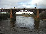 Upload another image | |||
| Bothwell, Blantyre Mill Road, Entrance To Elmwood Mansion, Including Gate Piers, Gates, Boundary Walls And Railings | 55°48′09″N 4°04′28″W / 55.802613°N 4.074473°W / 55.802613; -4.074473 (Bothwell, Blantyre Mill Road, Entrance To Elmwood Mansion, Including Gate Piers, Gates, Boundary Walls And Railings) | Category B | 88 | Upload Photo | |||
| Uddingston, 3 Glasgow Road, Primrose Bank, Including Gatepiers And Boundary Walls | 55°49′28″N 4°05′13″W / 55.824521°N 4.086863°W / 55.824521; -4.086863 (Uddingston, 3 Glasgow Road, Primrose Bank, Including Gatepiers And Boundary Walls) | Category C(S) | 45091 | Upload Photo | |||
| Uddingston, Blantyre Farm Road, Haughhead Bridge | 55°49′46″N 4°06′03″W / 55.829359°N 4.100965°W / 55.829359; -4.100965 (Uddingston, Blantyre Farm Road, Haughhead Bridge) | Category B | 45092 |  Upload another image | |||
| Uddingston, Old Mill Road, The Rowan Tree Inn | 55°49′11″N 4°04′51″W / 55.819805°N 4.080911°W / 55.819805; -4.080911 (Uddingston, Old Mill Road, The Rowan Tree Inn) | Category B | 6453 | Upload Photo | |||
| Bothwell, 1-3 Main Street (Odd Nos), Camphill Vaults Public House | 55°48′07″N 4°03′58″W / 55.801953°N 4.066189°W / 55.801953; -4.066189 (Bothwell, 1-3 Main Street (Odd Nos), Camphill Vaults Public House) | Category C(S) | 6375 | Upload Photo | |||
| Bothwell Castle Park, The Poultry | 55°48′52″N 4°05′25″W / 55.814552°N 4.090175°W / 55.814552; -4.090175 (Bothwell Castle Park, The Poultry) | Category B | 5149 | Upload Photo | |||
| Bothwell, Main Street, Russell Memorial Hall, Including Gatepiers, Boundary Walls And Railings | 55°48′13″N 4°04′06″W / 55.803688°N 4.068275°W / 55.803688; -4.068275 (Bothwell, Main Street, Russell Memorial Hall, Including Gatepiers, Boundary Walls And Railings) | Category C(S) | 47151 | Upload Photo | |||
| Bothwell, 60 Main Street, Bothwell Evangelical Church, Including Boundary Walls, Gatepiers, Gates And Railings | 55°48′17″N 4°04′12″W / 55.804664°N 4.070114°W / 55.804664; -4.070114 (Bothwell, 60 Main Street, Bothwell Evangelical Church, Including Boundary Walls, Gatepiers, Gates And Railings) | Category B | 45082 | Upload Photo | |||
| Bothwell, 3 Orchard Avenue, Anchorage House, Including Gatepiers | 55°47′59″N 4°03′47″W / 55.799679°N 4.062989°W / 55.799679; -4.062989 (Bothwell, 3 Orchard Avenue, Anchorage House, Including Gatepiers) | Category C(S) | 45085 | Upload Photo | |||
| Uddingston, Bowling And Tennis Club, Bowling Pavilion | 55°49′08″N 4°05′04″W / 55.818953°N 4.084505°W / 55.818953; -4.084505 (Uddingston, Bowling And Tennis Club, Bowling Pavilion) | Category C(S) | 45094 | Upload Photo | |||
| Uddingston, Church Street And Main Street, Park United Free Church Of Scotland, Including Adjoining Church Hall Boundary Walls, Gatepiers And Railings | 55°49′12″N 4°04′59″W / 55.81992°N 4.08312°W / 55.81992; -4.08312 (Uddingston, Church Street And Main Street, Park United Free Church Of Scotland, Including Adjoining Church Hall Boundary Walls, Gatepiers And Railings) | Category B | 45096 | Upload Photo | |||
| Bothwell, 7 Fairyknowe Gardens, Mansfield, Including Gatepiers, Boundary Walls And Outbuilding | 55°48′14″N 4°03′58″W / 55.803823°N 4.066128°W / 55.803823; -4.066128 (Bothwell, 7 Fairyknowe Gardens, Mansfield, Including Gatepiers, Boundary Walls And Outbuilding) | Category B | 45072 | Upload Photo | |||
| Bothwell, 8-10 (Even Nos), Main Street, Including Gatepiers And Boundary Walls | 55°48′09″N 4°04′00″W / 55.802602°N 4.06659°W / 55.802602; -4.06659 (Bothwell, 8-10 (Even Nos), Main Street, Including Gatepiers And Boundary Walls) | Category C(S) | 45080 | Upload Photo | |||
| Bothwell, 26 Silverwells Crescent, Including Gatepiers, Gates And Boundary Walls | 55°47′59″N 4°04′20″W / 55.799729°N 4.072309°W / 55.799729; -4.072309 (Bothwell, 26 Silverwells Crescent, Including Gatepiers, Gates And Boundary Walls) | Category C(S) | 45089 | Upload Photo | |||
| Uddingston, Station Road, Uddingston Grammar School, (Original Core Only), Including Gatepiers, Boundary Walls And Railings | 55°49′23″N 4°05′12″W / 55.822972°N 4.08654°W / 55.822972; -4.08654 (Uddingston, Station Road, Uddingston Grammar School, (Original Core Only), Including Gatepiers, Boundary Walls And Railings) | Category C(S) | 45104 | Upload Photo | |||
| Bothwell, Bothwell Park Road, Bothwell Park House | 55°48′33″N 4°03′22″W / 55.809214°N 4.056025°W / 55.809214; -4.056025 (Bothwell, Bothwell Park Road, Bothwell Park House) | Category B | 5140 | Upload Photo | |||
| Bothwell, 20 And 22 Green Street, Greenbank | 55°48′12″N 4°03′49″W / 55.803343°N 4.063725°W / 55.803343; -4.063725 (Bothwell, 20 And 22 Green Street, Greenbank) | Category B | 5143 | Upload Photo | |||
| Bothwell, 1-8 (Inclusive Nos) Blantyre Mill Road, Elmwood Mansion | 55°48′11″N 4°04′25″W / 55.803142°N 4.073512°W / 55.803142; -4.073512 (Bothwell, 1-8 (Inclusive Nos) Blantyre Mill Road, Elmwood Mansion) | Category B | 5145 | Upload Photo |
Key
The scheme for classifying buildings in Scotland is:
- Category A: "buildings of national or international importance, either architectural or historic; or fine, little-altered examples of some particular period, style or building type."[1]
- Category B: "buildings of regional or more than local importance; or major examples of some particular period, style or building type, which may have been altered."[1]
- Category C: "buildings of local importance; lesser examples of any period, style, or building type, as originally constructed or moderately altered; and simple traditional buildings which group well with other listed buildings."[1]
In March 2016 there were 47,288 listed buildings in Scotland. Of these, 8% were Category A, and 50% were Category B, with the remaining 42% being Category C.[2]
Notes
- ^ Sometimes known as OSGB36, the grid reference (where provided) is based on the British national grid reference system used by the Ordnance Survey.
• "Guide to National Grid". Ordnance Survey. Retrieved 12 December 2007.
• "Get-a-map". Ordnance Survey. Retrieved 17 December 2007. - ^ Historic Environment Scotland assign a unique alphanumeric identifier to each designated site in Scotland, for listed buildings this always begins with "LB", for example "LB12345".
References
- All entries, addresses and coordinates are based on data from Historic Scotland. This data falls under the Open Government Licence
External links
- Listed Buildings in Bothwell and Uddingston Ward, South Lanarkshire at British Listed Buildings
- ^ a b c "What is Listing?". Historic Environment Scotland. Retrieved 29 May 2018.
- ^ Scotland's Historic Environment Audit 2016 (PDF). Historic Environment Scotland and the Built Environment Forum Scotland. pp. 15–16. Retrieved 29 May 2018.
- v
- t
- e
- All in Category A
- Avondale
- Biggar
- Blantyre
- Bothwell
- Cambuslang
- Carluke
- Carmichael
- Carmunnock
- Carnwath
- Carstairs
- Covington
- Crawford
- Crawfordjohn
- Culter
- Dalserf
- Dolphinton
- Douglas
- Dunsyre
- East Kilbride
- Glassford
- Hamilton
- Lanark
- Lesmahagow
- Libberton
- Pettinain
- Rutherglen
- Stonehouse
- Symington
- Walston
- Wandel And Lamington
- Wiston And Roberton


