List of listed buildings in Symington, South Lanarkshire
This is a list of listed buildings in the parish of Symington in South Lanarkshire, Scotland.
Map all coordinates using OpenStreetMap
Download coordinates as:
- KML
- GPX (all coordinates)
- GPX (primary coordinates)
- GPX (secondary coordinates)
List
| Name | Location | Date Listed | Grid Ref. [note 1] | Geo-coordinates | Notes | LB Number [note 2] | Image |
|---|---|---|---|---|---|---|---|
| The Old Manse | 55°36′02″N 3°35′30″W / 55.600646°N 3.591635°W / 55.600646; -3.591635 (The Old Manse) | Category C(S) | 14170 |  Upload Photo | |||
| Watchhouse And Church Yard | 55°35′58″N 3°35′26″W / 55.599472°N 3.590683°W / 55.599472; -3.590683 (Watchhouse And Church Yard) | Category B | 14169 | Upload Photo | |||
| The Round House | 55°35′54″N 3°34′24″W / 55.598239°N 3.573397°W / 55.598239; -3.573397 (The Round House) | Category B | 14171 | Upload Photo | |||
| Parish Church | 55°35′59″N 3°35′26″W / 55.599716°N 3.59063°W / 55.599716; -3.59063 (Parish Church) | Category B | 14168 | Upload Photo | |||
| Symington House | 55°36′01″N 3°34′23″W / 55.600237°N 3.573191°W / 55.600237; -3.573191 (Symington House) | Category A | 19673 | 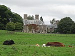 Upload another image | |||
| Symington House Garage Cottage | 55°35′55″N 3°34′24″W / 55.598526°N 3.573472°W / 55.598526; -3.573472 (Symington House Garage Cottage) | Category B | 19224 | Upload Photo | |||
| Fatlips Castle | 55°35′21″N 3°38′18″W / 55.589041°N 3.638261°W / 55.589041; -3.638261 (Fatlips Castle) | Category B | 14172 | Upload Photo | |||
| Symington House Lodge Gatepiers And Gates | 55°35′55″N 3°34′23″W / 55.598604°N 3.572983°W / 55.598604; -3.572983 (Symington House Lodge Gatepiers And Gates) | Category B | 19223 | Upload Photo |
Key
The scheme for classifying buildings in Scotland is:
- Category A: "buildings of national or international importance, either architectural or historic; or fine, little-altered examples of some particular period, style or building type."[1]
- Category B: "buildings of regional or more than local importance; or major examples of some particular period, style or building type, which may have been altered."[1]
- Category C: "buildings of local importance; lesser examples of any period, style, or building type, as originally constructed or moderately altered; and simple traditional buildings which group well with other listed buildings."[1]
In March 2016 there were 47,288 listed buildings in Scotland. Of these, 8% were Category A, and 50% were Category B, with the remaining 42% being Category C.[2]
Notes
- ^ Sometimes known as OSGB36, the grid reference (where provided) is based on the British national grid reference system used by the Ordnance Survey.
• "Guide to National Grid". Ordnance Survey. Retrieved 12 December 2007.
• "Get-a-map". Ordnance Survey. Retrieved 17 December 2007. - ^ Historic Environment Scotland assign a unique alphanumeric identifier to each designated site in Scotland, for listed buildings this always begins with "LB", for example "LB12345".
References
- All entries, addresses and coordinates are based on data from Historic Scotland. This data falls under the Open Government Licence
- ^ a b c "What is Listing?". Historic Environment Scotland. Retrieved 29 May 2018.
- ^ Scotland's Historic Environment Audit 2016 (PDF). Historic Environment Scotland and the Built Environment Forum Scotland. pp. 15–16. Retrieved 29 May 2018.
- v
- t
- e
- All in Category A
- Avondale
- Biggar
- Blantyre
- Bothwell
- Cambuslang
- Carluke
- Carmichael
- Carmunnock
- Carnwath
- Carstairs
- Covington
- Crawford
- Crawfordjohn
- Culter
- Dalserf
- Dolphinton
- Douglas
- Dunsyre
- East Kilbride
- Glassford
- Hamilton
- Lanark
- Lesmahagow
- Libberton
- Pettinain
- Rutherglen
- Stonehouse
- Symington
- Walston
- Wandel And Lamington
- Wiston And Roberton


