List of listed buildings in Douglas, South Lanarkshire
This is a list of listed buildings in the parish of Douglas in South Lanarkshire, Scotland.
Map all coordinates using OpenStreetMap
Download coordinates as:
- KML
- GPX (all coordinates)
- GPX (primary coordinates)
- GPX (secondary coordinates)
List
| Name | Location | Date Listed | Grid Ref. [note 1] | Geo-coordinates | Notes | LB Number [note 2] | Image |
|---|---|---|---|---|---|---|---|
| Douglas Village 2, 4 Clyde Road | 55°33′28″N 3°50′48″W / 55.557753°N 3.846553°W / 55.557753; -3.846553 (Douglas Village 2, 4 Clyde Road) | Category C(S) | 1455 |  Upload Photo | |||
| Douglas Village Douglas Parish Church | 55°33′31″N 3°50′40″W / 55.558486°N 3.844447°W / 55.558486; -3.844447 (Douglas Village Douglas Parish Church) | Category B | 1456 | Upload Photo | |||
| Douglas Village 63, 65 Main Street | 55°33′29″N 3°50′50″W / 55.558002°N 3.847326°W / 55.558002; -3.847326 (Douglas Village 63, 65 Main Street) | Category C(S) | 1459 | Upload Photo | |||
| Douglas Village 67, 69 Main Street | 55°33′29″N 3°50′50″W / 55.557995°N 3.84723°W / 55.557995; -3.84723 (Douglas Village 67, 69 Main Street) | Category C(S) | 1460 | Upload Photo | |||
| Douglas Village 62, 64, 66 Main Street | 55°33′28″N 3°50′49″W / 55.55779°N 3.847078°W / 55.55779; -3.847078 (Douglas Village 62, 64, 66 Main Street) | Category C(S) | 1486 | Upload Photo | |||
| Douglas Village 74 Main Street Sun Inn | 55°33′29″N 3°50′49″W / 55.55801°N 3.846834°W / 55.55801; -3.846834 (Douglas Village 74 Main Street Sun Inn) | Category B | 1487 | Upload Photo | |||
| Douglas Village 7 The Loaning | 55°33′29″N 3°50′45″W / 55.557942°N 3.845959°W / 55.557942; -3.845959 (Douglas Village 7 The Loaning) | Category C(S) | 1492 | Upload Photo | |||
| 42 Ayr Road, Braehead (Also Known As 3 Braehead) | 55°33′26″N 3°50′41″W / 55.557358°N 3.844774°W / 55.557358; -3.844774 (42 Ayr Road, Braehead (Also Known As 3 Braehead)) | Category C(S) | 50884 | Upload Photo | |||
| Douglas Village 38 Ayr Road Earlston | 55°33′27″N 3°50′39″W / 55.557482°N 3.844304°W / 55.557482; -3.844304 (Douglas Village 38 Ayr Road Earlston) | Category B | 1452 | Upload Photo | |||
| Douglas Village 5 The Loaning | 55°33′29″N 3°50′46″W / 55.558039°N 3.846106°W / 55.558039; -3.846106 (Douglas Village 5 The Loaning) | Category C(S) | 1491 | Upload Photo | |||
| Happendon Lodge | 55°34′57″N 3°49′18″W / 55.582407°N 3.821738°W / 55.582407; -3.821738 (Happendon Lodge) | Category B | 1494 | Upload Photo | |||
| Old Poneil Bridge | 55°35′48″N 3°49′18″W / 55.596759°N 3.821753°W / 55.596759; -3.821753 (Old Poneil Bridge) | Category B | 1497 | Upload Photo | |||
| Douglas Village Ayr Road Springhill | 55°33′13″N 3°50′56″W / 55.553603°N 3.848815°W / 55.553603; -3.848815 (Douglas Village Ayr Road Springhill) | Category B | 1451 | Upload Photo | |||
| Douglas Village Bell's Wynd, Douglas Heritage Museum (Former St Sophia's Episcopal Church) | 55°33′30″N 3°50′52″W / 55.558383°N 3.847724°W / 55.558383; -3.847724 (Douglas Village Bell's Wynd, Douglas Heritage Museum (Former St Sophia's Episcopal Church)) | Category B | 1454 | Upload Photo | |||
| Douglas Village Earl Of Angus' Monument | 55°33′30″N 3°50′57″W / 55.558308°N 3.849084°W / 55.558308; -3.849084 (Douglas Village Earl Of Angus' Monument) | Category A | 1457 |  Upload another image | |||
| Parkhall | 55°34′47″N 3°48′28″W / 55.579639°N 3.807808°W / 55.579639; -3.807808 (Parkhall) | Category C(S) | 1461 | Upload Photo | |||
| Wolfcrooks Bridge | 55°36′19″N 3°48′06″W / 55.605331°N 3.801782°W / 55.605331; -3.801782 (Wolfcrooks Bridge) | Category B | 1464 | Upload Photo | |||
| Douglas Village 56, 58, 60 Main Street | 55°33′28″N 3°50′50″W / 55.55767°N 3.84731°W / 55.55767; -3.84731 (Douglas Village 56, 58, 60 Main Street) | Category C(S) | 1485 | Upload Photo | |||
| Millbank | 55°34′37″N 3°48′31″W / 55.576894°N 3.808681°W / 55.576894; -3.808681 (Millbank) | Category C(S) | 1495 | Upload Photo | |||
| Castle Mains | 55°34′29″N 3°48′33″W / 55.574764°N 3.809281°W / 55.574764; -3.809281 (Castle Mains) | Category B | 1448 | Upload Photo | |||
| New Mains | 55°33′45″N 3°49′41″W / 55.562587°N 3.828052°W / 55.562587; -3.828052 (New Mains) | Category B | 1496 | Upload Photo | |||
| 81 And 83 Ayr Road | 55°33′20″N 3°50′52″W / 55.555586°N 3.847846°W / 55.555586; -3.847846 (81 And 83 Ayr Road) | Category C(S) | 50883 | Upload Photo | |||
| Douglas Estate Douglas Castle | 55°33′59″N 3°50′14″W / 55.56645°N 3.837176°W / 55.56645; -3.837176 (Douglas Estate Douglas Castle) | Category C(S) | 1449 | Upload Photo | |||
| Douglas Village 61 Main Street | 55°33′28″N 3°50′51″W / 55.557909°N 3.847543°W / 55.557909; -3.847543 (Douglas Village 61 Main Street) | Category C(S) | 1458 | Upload Photo | |||
| Douglas Village 87, 89 Main Street | 55°33′32″N 3°50′45″W / 55.55886°N 3.845891°W / 55.55886; -3.845891 (Douglas Village 87, 89 Main Street) | Category C(S) | 1484 | Upload Photo | |||
| Douglas Village 84 Main Street | 55°33′29″N 3°50′48″W / 55.558122°N 3.846538°W / 55.558122; -3.846538 (Douglas Village 84 Main Street) | Category C(S) | 1488 | Upload Photo | |||
| Douglas Village 2, 4 The Loaning | 55°33′28″N 3°50′46″W / 55.557885°N 3.846147°W / 55.557885; -3.846147 (Douglas Village 2, 4 The Loaning) | Category C(S) | 1493 | Upload Photo | |||
| Douglas Village Ayr Road Douglas Arms Hotel | 55°33′21″N 3°50′53″W / 55.555844°N 3.848017°W / 55.555844; -3.848017 (Douglas Village Ayr Road Douglas Arms Hotel) | Category B | 1453 | Upload Photo | |||
| Douglas Village Mansefield | 55°33′17″N 3°50′47″W / 55.55462°N 3.846342°W / 55.55462; -3.846342 (Douglas Village Mansefield) | Category B | 1489 | Upload Photo | |||
| Douglas Estate North Bridge Over Burnhouse Burn | 55°33′35″N 3°50′44″W / 55.559666°N 3.845453°W / 55.559666; -3.845453 (Douglas Estate North Bridge Over Burnhouse Burn) | Category C(S) | 1450 | Upload Photo | |||
| Uddington Village Ptarmigan Cottage | 55°34′48″N 3°48′19″W / 55.580038°N 3.805161°W / 55.580038; -3.805161 (Uddington Village Ptarmigan Cottage) | Category C(S) | 1462 | Upload Photo | |||
| Uddington Village, Konisberg | 55°34′48″N 3°48′19″W / 55.580038°N 3.805161°W / 55.580038; -3.805161 (Uddington Village, Konisberg) | Category B | 1463 | Upload Photo | |||
| Douglas Village St Bride's Chapel & Churchyard Walls | 55°33′30″N 3°50′50″W / 55.55831°N 3.847181°W / 55.55831; -3.847181 (Douglas Village St Bride's Chapel & Churchyard Walls) | Category A | 1490 | 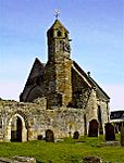 Upload another image |
Key
The scheme for classifying buildings in Scotland is:
- Category A: "buildings of national or international importance, either architectural or historic; or fine, little-altered examples of some particular period, style or building type."[1]
- Category B: "buildings of regional or more than local importance; or major examples of some particular period, style or building type, which may have been altered."[1]
- Category C: "buildings of local importance; lesser examples of any period, style, or building type, as originally constructed or moderately altered; and simple traditional buildings which group well with other listed buildings."[1]
In March 2016 there were 47,288 listed buildings in Scotland. Of these, 8% were Category A, and 50% were Category B, with the remaining 42% being Category C.[2]
Notes
- ^ Sometimes known as OSGB36, the grid reference (where provided) is based on the British national grid reference system used by the Ordnance Survey.
• "Guide to National Grid". Ordnance Survey. Retrieved 12 December 2007.
• "Get-a-map". Ordnance Survey. Retrieved 17 December 2007. - ^ Historic Environment Scotland assign a unique alphanumeric identifier to each designated site in Scotland, for listed buildings this always begins with "LB", for example "LB12345".
References
- All entries, addresses and coordinates are based on data from Historic Scotland. This data falls under the Open Government Licence
- ^ a b c "What is Listing?". Historic Environment Scotland. Retrieved 29 May 2018.
- ^ Scotland's Historic Environment Audit 2016 (PDF). Historic Environment Scotland and the Built Environment Forum Scotland. pp. 15–16. Retrieved 29 May 2018.
- v
- t
- e
- All in Category A
- Avondale
- Biggar
- Blantyre
- Bothwell
- Cambuslang
- Carluke
- Carmichael
- Carmunnock
- Carnwath
- Carstairs
- Covington
- Crawford
- Crawfordjohn
- Culter
- Dalserf
- Dolphinton
- Douglas
- Dunsyre
- East Kilbride
- Glassford
- Hamilton
- Lanark
- Lesmahagow
- Libberton
- Pettinain
- Rutherglen
- Stonehouse
- Symington
- Walston
- Wandel And Lamington
- Wiston And Roberton


