National Register of Historic Places listings in Butler County, Kentucky

This is a list of the National Register of Historic Places listings in Butler County, Kentucky.
This is intended to be a complete list of the properties and districts on the National Register of Historic Places in Butler County, Kentucky, United States. The locations of National Register properties and districts for which the latitude and longitude coordinates are included below, may be seen in a map.[1]
There are 16 properties and districts listed on the National Register in the county, of which 6 are part of a National Historic Landmark spread across multiple counties. Another property was once listed but has been removed.
This National Park Service list is complete through NPS recent listings posted September 5, 2024.[2]
Map all coordinates using OpenStreetMap
Download coordinates as:
- KML
- GPX (all coordinates)
- GPX (primary coordinates)
- GPX (secondary coordinates)
Current listings
| [3] | Name on the Register | Image | Date listed[4] | Location | City or town | Description |
|---|---|---|---|---|---|---|
| 1 | Annis Mound and Village Site (15BT2; 15BT20; 15BT21) |  | December 21, 1985 (#85003182) | Western bank of the Green River in Horseshoe Bend, northeast of Logansport[5] 37°17′25″N 86°45′30″W / 37.290278°N 86.758333°W / 37.290278; -86.758333 (Annis Mound and Village Site (15BT2; 15BT20; 15BT21)) | Logansport | |
| 2 | Baby Track Rock Petroglyphs (15BT40) | Upload image | September 8, 1989 (#89001175) | Address Restricted | Morgantown | |
| 3 | Carlston Annis Shell Mound (15BT5) | Upload image | April 1, 1986 (#86000632) | Eastern side of the Green River off Kentucky Route 403[6] 37°17′28″N 86°48′19″W / 37.291111°N 86.805278°W / 37.291111; -86.805278 (Carlston Annis Shell Mound (15BT5)) | Schulztown | Part of the Green River Shell Middens Archeological District National Historic Landmark[7]: 8 |
| 4 | John Carson House |  | July 26, 1991 (#91000922) | 205 S. Main St. 37°13′28″N 86°41′06″W / 37.224444°N 86.685000°W / 37.224444; -86.685000 (John Carson House) | Morgantown | |
| 5 | Carson-Annis Ferry Farm |  | July 31, 1998 (#98000935) | 1086 Annis Ferry Rd. 37°17′39″N 86°45′10″W / 37.294167°N 86.752778°W / 37.294167; -86.752778 (Carson-Annis Ferry Farm) | Morgantown | Originally listed as "Carson's Landing", but boundaries increased and name changed on April 10, 2007 |
| 6 | Confederate-Union Veterans' Monument in Morgantown |  | July 17, 1997 (#97000713) | 1 block north of the junction of U.S. Route 231 and KY 403 37°13′32″N 86°41′00″W / 37.225500°N 86.683222°W / 37.225500; -86.683222 (Confederate-Union Veterans' Monument in Morgantown) | Morgantown | |
| 7 | DeWeese Shell Mound (15BT6) | Upload image | April 1, 1986 (#86000635) | Eastern bank of the Green River in Horseshoe Bend, west of Taylor Lake[5] 37°18′26″N 86°49′04″W / 37.307222°N 86.817778°W / 37.307222; -86.817778 (DeWeese Shell Mound (15BT6)) | Highview | Part of the Green River Shell Middens Archeological District National Historic Landmark[7]: 9 |
| 8 | Finney Hotel |  | November 7, 1995 (#95001349) | Junction of Kentucky Route 403 and Hime St. 37°11′04″N 86°38′01″W / 37.184306°N 86.633611°W / 37.184306; -86.633611 (Finney Hotel) | Woodbury | |
| 9 | Ice House on Little Muddy Creek | Upload image | January 8, 1987 (#87000171) | U.S. Route 231 37°09′14″N 86°40′33″W / 37.153889°N 86.675833°W / 37.153889; -86.675833 (Ice House on Little Muddy Creek) | Morgantown | |
| 10 | Rayburn Johnson Shell Mound (15BT41) |  | April 1, 1986 (#86000633) | Eastern bank of the Green River in Horseshoe Bend, northwest of Taylor Lake[8] 37°19′28″N 86°49′04″W / 37.324444°N 86.817778°W / 37.324444; -86.817778 (Rayburn Johnson Shell Mound (15BT41)) | Prentiss | Part of the Green River Shell Middens Archeological District National Historic Landmark[7]: 12 |
| 11 | Read Shell Mound (15BT10) | Upload image | April 1, 1986 (#86000647) | Northern side of the Green River, west of Morgantown[9]: 120 37°14′33″N 86°47′27″W / 37.242500°N 86.790833°W / 37.242500; -86.790833 (Read Shell Mound (15BT10)) | Monticello | Part of the Green River Shell Middens Archeological District National Historic Landmark[7]: 10 |
| 12 | Reedyville Petroglyphs (15BT65) | Upload image | September 8, 1989 (#89001176) | Lock 5 Rd., just north of the Green River[10] 37°10′02″N 86°24′52″W / 37.167222°N 86.414306°W / 37.167222; -86.414306 (Reedyville Petroglyphs (15BT65)) | Reedyville | |
| 13 | Russell Shell Mound (15BT11) | Upload image | April 1, 1986 (#86000637) | Eastern bank of the Green River in Horseshoe Bend[5] 37°16′16″N 86°48′01″W / 37.271111°N 86.800278°W / 37.271111; -86.800278 (Russell Shell Mound (15BT11)) | Logansport | Part of the Green River Shell Middens Archeological District National Historic Landmark[7]: 11 |
| 14 | Turkey Rock Petroglyphs (15BT64) | Upload image | September 8, 1989 (#89001177) | Address Restricted | Morgantown | |
| 15 | U.S. Army Corps of Engineers Superintendent's House and Workmen's Office | 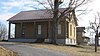 | June 19, 1980 (#80001489) | Woodbury Park 37°11′05″N 86°37′56″W / 37.184861°N 86.632222°W / 37.184861; -86.632222 (U.S. Army Corps of Engineers Superintendent's House and Workmen's Office) | Woodbury | |
| 16 | Woodbury Shell Midden (15BT67) |  | April 1, 1986 (#86000639) | Left bank of the Green River immediately above Woodbury[8] 37°10′51″N 86°37′39″W / 37.180833°N 86.627500°W / 37.180833; -86.627500 (Woodbury Shell Midden (15BT67)) | Woodbury | Part of the Green River Shell Middens Archeological District National Historic Landmark[7]: 13 |
Former listing
| [3] | Name on the Register | Image | Date listed | Date removed | Location | City or town | Description |
|---|---|---|---|---|---|---|---|
| 1 | Butler County Jail | Upload image | November 1, 1984 (#84000219) | July 5, 1990 | S. Warren and E. Logan Sts. | Morgantown |
See also
Wikimedia Commons has media related to National Register of Historic Places in Butler County, Kentucky.
References
- ^ The latitude and longitude information provided in this table was derived originally from the National Register Information System, which has been found to be fairly accurate for about 99% of listings. Some locations in this table may have been corrected to current GPS standards.
- ^ National Park Service, United States Department of the Interior, "National Register of Historic Places: Weekly List Actions", retrieved September 5, 2024.
- ^ a b Numbers represent an alphabetical ordering by significant words. Various colorings, defined here, differentiate National Historic Landmarks and historic districts from other NRHP buildings, structures, sites or objects.
- ^ The eight-digit number below each date is the number assigned to each location in the National Register Information System database, which can be viewed by clicking the number.
- ^ a b c Funkhouser, W.D., and W.S. Webb. "Archaeological Survey of Kentucky: Butler County". University of Kentucky Reports in Anthropology 7.5 (1950): 358.
- ^ Funkhouser, W.D., and W.S. Webb. "Archaeological Survey of Kentucky: Butler County". University of Kentucky Reports in Anthropology 2 (1932): 56.
- ^ a b c d e f National Historic Landmark Nomination: Green River Shell Middens. National Park Service: 1994-05-05.
- ^ a b Claassen, Cheryl. Feasting with Shellfish in the Southern Ohio Valley: Archaic Sacred Sites and Rituals. Knoxville: U of Tennessee P, 2010, 41.
- ^ Milner, George R., and Richard W. Jefferies. "The Read Archaic Shell Midden in Kentucky". Southeastern Archaeology 17.2 (1998): 119-132.
- ^ Coy, Fred E., Jr., and Thomas C. Fuller. "Reedyville Petroglyphs: Butler County, Kentucky". Central States Archaeological Journal 17.3 (1970): 99-111: 103.
- v
- t
- e
- List of U.S. National Historic Landmarks by state:
- Alabama
- Alaska
- Arizona
- Arkansas
- California
- Colorado
- Connecticut
- Delaware
- Florida
- Georgia
- Hawaii
- Idaho
- Illinois
- Indiana
- Iowa
- Kansas
- Kentucky
- Louisiana
- Maine
- Maryland
- Massachusetts
- Michigan
- Minnesota
- Mississippi
- Missouri
- Montana
- Nebraska
- Nevada
- New Hampshire
- New Jersey
- New Mexico
- New York
- North Carolina
- North Dakota
- Ohio
- Oklahoma
- Oregon
- Pennsylvania
- Rhode Island
- South Carolina
- South Dakota
- Tennessee
- Texas
- Utah
- Vermont
- Virginia
- Washington
- West Virginia
- Wisconsin
- Wyoming
 National Register of Historic Places portal
 Category


Municipalities and communities of Butler County, Kentucky, United States | ||
|---|---|---|
County seat: Morgantown | ||
| Cities |  | |
| Unincorporated communities | ||
| Footnotes | ‡This populated place also has portions in an adjacent county or counties | |
| ||


