National Register of Historic Places listings in Daviess County, Kentucky

This is a list of the National Register of Historic Places listings in Daviess County, Kentucky.
This is intended to be a complete list of the properties and districts on the National Register of Historic Places in Daviess County, Kentucky, United States. The locations of National Register properties and districts for which the latitude and longitude coordinates are included below, may be seen in a map.[1]
There are 38 properties and districts listed on the National Register in the county. Another property was once listed but has been removed.
This National Park Service list is complete through NPS recent listings posted September 5, 2024.[2]
Map all coordinates using OpenStreetMap
Download coordinates as:
- KML
- GPX (all coordinates)
- GPX (primary coordinates)
- GPX (secondary coordinates)
Current listings
| [3] | Name on the Register | Image | Date listed[4] | Location | City or town | Description |
|---|---|---|---|---|---|---|
| 1 | Archeological Site 15 Da 39 |  | December 22, 1978 (#78001310) | Off the Ohio River shoreline northeast of Owensboro[5] 37°51′30″N 87°01′54″W / 37.858333°N 87.031667°W / 37.858333; -87.031667 (Archeological Site 15 Da 39) | Maceo | |
| 2 | D.D. Bogard House |  | May 22, 1980 (#80001503) | 303 E. 4th St. 37°46′23″N 87°06′30″W / 37.773056°N 87.108333°W / 37.773056; -87.108333 (D.D. Bogard House) | Owensboro | |
| 3 | Breidenbach Building |  | March 28, 1986 (#86000660) | 208 W. 3rd St. 37°46′25″N 87°06′46″W / 37.773611°N 87.112667°W / 37.773611; -87.112667 (Breidenbach Building) | Owensboro | |
| 4 | Callas Sweet Shop |  | March 28, 1986 (#86000661) | 420 Frederica Ave. 37°46′19″N 87°06′49″W / 37.771944°N 87.113611°W / 37.771944; -87.113611 (Callas Sweet Shop) | Owensboro | |
| 5 | Carnegie Free Public Library (DAOB 41) |  | August 6, 1986 (#86002234) | 901 Frederica Ave. 37°46′02″N 87°06′45″W / 37.767222°N 87.112500°W / 37.767222; -87.112500 (Carnegie Free Public Library (DAOB 41)) | Owensboro | |
| 6 | Le Vega Clements House |  | March 28, 1986 (#86000663) | 1500 N. Highland Ave. 37°46′27″N 87°05′31″W / 37.774167°N 87.091944°W / 37.774167; -87.091944 (Le Vega Clements House) | Owensboro | |
| 7 | Confederate Monument in Owensboro |  | July 17, 1997 (#97000708) | 1 block north of the junction of U.S. Routes 60 and 431 37°46′26″N 87°06′48″W / 37.773889°N 87.113222°W / 37.773889; -87.113222 (Confederate Monument in Owensboro) | Owensboro | |
| 8 | Howell J. Davis House |  | August 3, 1990 (#90001168) | 3301 Veach Rd. 37°44′17″N 87°06′08″W / 37.738056°N 87.102222°W / 37.738056; -87.102222 (Howell J. Davis House) | Owensboro | |
| 9 | Doctors' Row Historic District |  | March 28, 1986 (#86000662) | W. 4th St. between Frederica and Saint Ann Sts. 37°46′22″N 87°06′44″W / 37.772778°N 87.112222°W / 37.772778; -87.112222 (Doctors' Row Historic District) | Owensboro | |
| 10 | Federal Building and US Post Office-Owensboro | 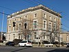 | April 13, 1989 (#89000295) | 5th and Frederica 37°46′18″N 87°06′46″W / 37.771667°N 87.112778°W / 37.771667; -87.112778 (Federal Building and US Post Office-Owensboro) | Owensboro | |
| 11 | Gillim House |  | March 28, 1986 (#86000664) | 517 Frederica St. 37°46′15″N 87°06′46″W / 37.770833°N 87.112778°W / 37.770833; -87.112778 (Gillim House) | Owensboro | |
| 12 | Felix Grimes House | Upload image | June 18, 1975 (#75000746) | 1301 Leitchfield Rd. 37°45′55″N 87°05′22″W / 37.765278°N 87.089444°W / 37.765278; -87.089444 (Felix Grimes House) | Owensboro | |
| 13 | Haphazard |  | August 22, 1975 (#75000747) | Pleasant Valley Rd. 37°46′56″N 87°04′24″W / 37.782222°N 87.073333°W / 37.782222; -87.073333 (Haphazard) | Owensboro | |
| 14 | Kentucky Buggy Company Building |  | September 29, 2015 (#15000649) | 301 E. 9th St. 37°46′04″N 87°06′28″W / 37.7677°N 87.1079°W / 37.7677; -87.1079 (Kentucky Buggy Company Building) | Owensboro | |
| 15 | Thomas Krahwinkel House | 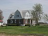 | July 30, 2013 (#13000556) | 10501 U.S. Route 60 37°50′37″N 87°18′39″W / 37.843611°N 87.310833°W / 37.843611; -87.310833 (Thomas Krahwinkel House) | Owensboro | |
| 16 | McKay-Thornberry House |  | May 3, 1984 (#84001408) | S. Hampton Rd. 37°45′42″N 86°58′00″W / 37.761667°N 86.966667°W / 37.761667; -86.966667 (McKay-Thornberry House) | Owensboro | |
| 17 | Medley House |  | February 20, 1980 (#80001504) | 1220 Frederica St. 37°45′52″N 87°06′47″W / 37.764444°N 87.113056°W / 37.764444; -87.113056 (Medley House) | Owensboro | |
| 18 | George Mischel and Sons Building |  | March 28, 1986 (#86000756) | 412 E. 2nd St. 37°46′30″N 87°06′25″W / 37.775000°N 87.107083°W / 37.775000; -87.107083 (George Mischel and Sons Building) | Owensboro | |
| 19 | Monarch-Payne House |  | March 28, 1986 (#86000757) | 1432 E. 4th St. 37°46′26″N 87°05′34″W / 37.773750°N 87.092778°W / 37.773750; -87.092778 (Monarch-Payne House) | Owensboro | |
| 20 | J.Z. Moore Historic District |  | March 28, 1986 (#86000659) | Roughly bounded by W. and E. 12th, Daviess, E. and W. 14th, and Saint Ann Sts. 37°45′51″N 87°06′37″W / 37.764167°N 87.110278°W / 37.764167; -87.110278 (J.Z. Moore Historic District) | Owensboro | |
| 21 | Moorman House |  | March 27, 1992 (#92000140) | 2731 W. 2nd St. 37°46′29″N 87°08′40″W / 37.774722°N 87.144444°W / 37.774722; -87.144444 (Moorman House) | Owensboro | |
| 22 | Mount St. Joseph Academy |  | January 25, 1979 (#79000970) | Kentucky Route 56 37°41′35″N 87°19′29″W / 37.693056°N 87.324722°W / 37.693056; -87.324722 (Mount St. Joseph Academy) | Saint Joseph | |
| 23 | Odd Fellows Building |  | March 28, 1986 (#86000758) | 200-204 W. 3rd St. 37°46′25″N 87°06′45″W / 37.773611°N 87.112500°W / 37.773611; -87.112500 (Odd Fellows Building) | Owensboro | |
| 24 | Owensboro Armory |  | September 6, 2002 (#02000919) | 1501 Parrish Ave. 37°45′40″N 87°07′34″W / 37.761111°N 87.126111°W / 37.761111; -87.126111 (Owensboro Armory) | Owensboro | Demolished 2012 |
| 25 | Owensboro Historic Commercial District |  | January 12, 1983 (#83002626) | 2nd St. between St. Ann and Lewis Sts. 37°46′29″N 87°06′38″W / 37.774722°N 87.110556°W / 37.774722; -87.110556 (Owensboro Historic Commercial District) | Owensboro | |
| 26 | Owensboro Historic Downtown Commercial District |  | July 26, 2005 (#04001251) | Roughly between Frederica, Clay, 2nd, and 4th Sts. 37°46′27″N 87°06′38″W / 37.774167°N 87.110556°W / 37.774167; -87.110556 (Owensboro Historic Downtown Commercial District) | Owensboro | |
| 27 | Phillip's Court District |  | March 28, 1986 (#86000658) | Roughly bounded by Technical High School, Cruze Dr., W. 18th St., and Frederica Ave. 37°45′39″N 87°06′40″W / 37.760833°N 87.111111°W / 37.760833; -87.111111 (Phillip's Court District) | Owensboro | |
| 28 | Camden Riley House |  | March 28, 1986 (#86000760) | 112 E. 4th St. 37°46′21″N 87°06′51″W / 37.772500°N 87.114167°W / 37.772500; -87.114167 (Camden Riley House) | Owensboro | |
| 29 | St. Joseph Church |  | November 3, 1983 (#83003651) | 4th and Clay Sts. 37°46′22″N 87°06′22″W / 37.772778°N 87.106111°W / 37.772778; -87.106111 (St. Joseph Church) | Owensboro | |
| 30 | Maj. Hampden Smith House |  | September 28, 1976 (#76000865) | 909 Frederica St. 37°46′01″N 87°06′44″W / 37.767056°N 87.112222°W / 37.767056; -87.112222 (Maj. Hampden Smith House) | Owensboro | |
| 31 | James L. Stinnett House |  | December 30, 2019 (#100004830) | 10184 Hwy 54 37°40′59″N 86°52′05″W / 37.6831°N 86.8680°W / 37.6831; -86.8680 (James L. Stinnett House) | Whitesville | |
| 32 | James J. Sweeney House |  | August 11, 1980 (#80001505) | 121 E. 5th St. 37°46′19″N 87°06′36″W / 37.771944°N 87.110000°W / 37.771944; -87.110000 (James J. Sweeney House) | Owensboro | |
| 33 | Temple Adath Israel | 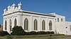 | March 28, 1986 (#86000761) | 429 Daviess St. 37°46′19″N 87°06′34″W / 37.771833°N 87.109444°W / 37.771833; -87.109444 (Temple Adath Israel) | Owensboro | |
| 34 | Thompson and Powell Martyrs Monument |  | July 17, 1997 (#97000707) | Junction of Kentucky Routes 56 and 500 37°41′44″N 87°19′30″W / 37.695556°N 87.325111°W / 37.695556; -87.325111 (Thompson and Powell Martyrs Monument) | Saint Joseph | |
| 35 | Trinity Episcopal Church | 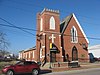 | April 10, 1972 (#72000530) | 403 W. 5th St. 37°46′18″N 87°06′53″W / 37.771667°N 87.114722°W / 37.771667; -87.114722 (Trinity Episcopal Church) | Owensboro | |
| 36 | Union Station |  | August 1, 1979 (#79000969) | 1039 Frederica St. 37°45′57″N 87°06′43″W / 37.765833°N 87.111944°W / 37.765833; -87.111944 (Union Station) | Owensboro | |
| 37 | Willow Hill |  | June 9, 1982 (#82004621) | Jones Rd. 37°47′01″N 87°00′47″W / 37.783611°N 87.013056°W / 37.783611; -87.013056 (Willow Hill) | Owensboro | |
| 38 | Yewell House |  | March 28, 1986 (#86000762) | 630 Clay St. 37°46′12″N 87°06′23″W / 37.770000°N 87.106389°W / 37.770000; -87.106389 (Yewell House) | Owensboro |
Former listing
| [3] | Name on the Register | Image | Date listed | Date removed | Location | City or town | Description |
|---|---|---|---|---|---|---|---|
| 1 | Ames Building | Upload image | March 28, 1986 (#86000657) | October 17, 1988 | 401 W. Third St. | Owensboro | Was being partially demolished when it was destroyed by fire on July 17, 1987.[6][7] |
See also
Wikimedia Commons has media related to National Register of Historic Places in Daviess County, Kentucky.
- List of National Historic Landmarks in Kentucky
- National Register of Historic Places listings in Kentucky
References
- ^ The latitude and longitude information provided in this table was derived originally from the National Register Information System, which has been found to be fairly accurate for about 99% of listings. Some locations in this table may have been corrected to current GPS standards.
- ^ National Park Service, United States Department of the Interior, "National Register of Historic Places: Weekly List Actions", retrieved September 5, 2024.
- ^ a b Numbers represent an alphabetical ordering by significant words. Various colorings, defined here, differentiate National Historic Landmarks and historic districts from other NRHP buildings, structures, sites or objects.
- ^ The eight-digit number below each date is the number assigned to each location in the National Register Information System database, which can be viewed by clicking the number.
- ^ Pollack, David, ed. The Archaeology of Kentucky: An Update. Frankfort: Kentucky Heritage Council, 2008, 35.
- ^ "Fire razes part of downtown building". Messenger-Inquirer. July 18, 1987. p. 1A. Retrieved July 4, 2022 – via Newspapers.com.
- ^ https://npgallery.nps.gov/NRHP/GetAsset/NRHP/64000247_text
- v
- t
- e
- List of U.S. National Historic Landmarks by state:
- Alabama
- Alaska
- Arizona
- Arkansas
- California
- Colorado
- Connecticut
- Delaware
- Florida
- Georgia
- Hawaii
- Idaho
- Illinois
- Indiana
- Iowa
- Kansas
- Kentucky
- Louisiana
- Maine
- Maryland
- Massachusetts
- Michigan
- Minnesota
- Mississippi
- Missouri
- Montana
- Nebraska
- Nevada
- New Hampshire
- New Jersey
- New Mexico
- New York
- North Carolina
- North Dakota
- Ohio
- Oklahoma
- Oregon
- Pennsylvania
- Rhode Island
- South Carolina
- South Dakota
- Tennessee
- Texas
- Utah
- Vermont
- Virginia
- Washington
- West Virginia
- Wisconsin
- Wyoming
 National Register of Historic Places portal
 Category


