Richelieu, Kentucky
Unincorporated community in Kentucky, United States
37°0′16.53″N 86°41′30.27″W / 37.0045917°N 86.6917417°W / 37.0045917; -86.691741742271
Richelieu is an unincorporated community in Logan County and Butler County, Kentucky, United States.[1]
Geography
Richelieu is located near Logan County's northeastern boundary with Butler County along Kentucky Route 1038. It is also located near the tripoint where Logan and Butler County boundaries meet with those of Warren County.[2]
References
- ^ a b U.S. Geological Survey Geographic Names Information System: Richelieu, Kentucky
- ^ DeLorme (2010). Kentucky Atlas and Gazetteer (Map). Yarmouth, Maine: DeLorme. p. 63. § H10. ISBN 0-89933-340-0.
- v
- t
- e
 | This Butler County, Kentucky state location article is a stub. You can help Wikipedia by expanding it. |
- v
- t
- e
Municipalities and communities of Logan County, Kentucky, United States | ||
|---|---|---|
County seat: Russellville | ||
| Cities | 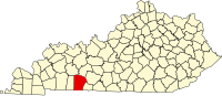 | |
| CDP | ||
| Other unincorporated communities | ||
| Footnotes | ‡This populated place also has portions in an adjacent county or counties | |
| ||
Municipalities and communities of Butler County, Kentucky, United States | ||
|---|---|---|
County seat: Morgantown | ||
| Cities |  | |
| Unincorporated communities | ||
| Footnotes | ‡This populated place also has portions in an adjacent county or counties | |
| ||


