Brookland Park Historic District
Historic district in Virginia, United States
United States historic place
Brookland Park Historic District | |
Virginia Landmarks Register | |
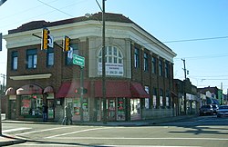 Brookland Park Historic District, January 2012 | |
37°34′58″N 77°26′51″W / 37.58278°N 77.44750°W / 37.58278; -77.44750 | |
| Area | 343 acres (139 ha) |
|---|---|
| Architectural style | Late 19th And 20th Century Revivals, Late 19th And Early 20th Century American Movements |
| MPS | Streetcar Suburbs in Northside Richmond MPS |
| NRHP reference No. | 02000591[1] |
| VLR No. | 127-5898 |
| Significant dates | |
| Added to NRHP | August 6, 2003 |
| Designated VLR | September 30, 2001[2] |
The Brookland Park Historic District is a national historic district located at Richmond, Virginia. The district encompasses 1,157 contributing buildings located north of downtown Richmond and Barton Heights.
Background
The primarily residential area developed starting in the late-19th century as one of the city's early “streetcar suburbs.” The buildings are in a variety of popular late-19th and early-20th century architectural styles including frame bungalows and American Foursquare. The neighborhood is characterized by frame dwellings with a single-story porch spanning the facade, and either Colonial Revival or Craftsman in style, moderate in scale, with understated materials and stylistic expression. Notable non-residential buildings include the North Side Branch building, Brookland Inn, former A&P Grocery Store, North Side Junior High School, Barack Obama Elementary School, St. Paul's School building (1923), St. Philip's Episcopal Church, First African Baptist Church (1922), and Garland Avenue Baptist Church.[3]
It was added to the National Register of Historic Places in 2003.[1]
References
- ^ a b "National Register Information System". National Register of Historic Places. National Park Service. July 9, 2010.
- ^ "Virginia Landmarks Register". Virginia Department of Historic Resources. Archived from the original on September 21, 2013. Retrieved March 19, 2013.
- ^ Kimberly Merkel Chen; Mary Harding Sadler; Peter MacDearmon Witt & Jean McRae (June 2003). "National Register of Historic Places Inventory/Nomination: Brookland Park Historic District" (PDF). Virginia Department of Historic Resources. Archived from the original (PDF) on September 27, 2012. Retrieved January 11, 2014. and Accompanying photo Archived 2012-09-27 at the Wayback Machine and Accompanying map Archived 2014-01-11 at the Wayback Machine
- v
- t
- e
Neighborhoods in Richmond, Virginia
- Arts District
- Banking District
- Biotech and MCV
- Central Office District
- City Center
- Court End
- East Franklin Block
- Financial District
- French Garden Hill
- Gambles Hill
- Jackson Ward
- Monroe Ward
- Riverside District
- Shockoe Bottom
- Shockoe Slip
- Upper Shockoe Valley
- Allen Heights
- Alton Heights
- Ashley Oaks
- Belmont
- Bolton and Taliaferrol
- Bowling Green
- Brauers
- Briels
- Cardinal Court
- Chimborazo
- Chimborazo Village
- Church Hill
- Church Hill North
- Creighton Court
- Eastlawn
- Eastview
- Fairfield
- Fairmount
- Fulton Hill
- Geffert Place
- Glenwood
- Guildts Estates
- Habitat Hills
- Harrison Place
- Howard's Grove
- Kuhn
- Libby Hill
- Linsville
- Mechaniscville Gardens
- Montrose Heights
- Mosby
- Mount Erin
- Montibello
- National Heights
- Navy Hill
- North Church Hill
- Oakwood
- Overhill Place
- Payne Square
- Peter Paul
- Powhatan
- Rainbow Village
- Rico
- Robinson Heights
- Rocketts Landing
- Rutherford Tract
- Shed Town
- Silver Crest
- Tobacco Row
- Tuxedo Park
- Union Hill
- Witcomb Court
- Wynwood
- Battery Court
- Barton Heights
- Bellevue
- Brookland Park
- Chamberlayne Industrial Center
- Chestnut Hill
- Chestnut Hill–Plateau
- Edgewood
- Gilpin
- Ginter Park
- Green Park
- Hermitage Road
- Highland Park
- Highland Terrace
- Laburnum Park
- Magnolia Industrial Center
- North Highland Park
- Pine Camp
- Providence Park
- Rosedale
- Sherwood Park
- Southern Barton Heights
- Virginia Union University
- Washington Park
- Ancarrow's Landing
- Ann's Acres
- Bellemeade
- Belmont Woods
- Blackwell
- Broad Rock
- Brookbury
- Brookside
- Buck Hill
- Cedarhurst
- Cherry Gardens
- Chippenham Forest
- Claremont
- Clopton
- Cofer
- Cotrell Farms
- Dorchester
- Fairway Acres
- Forest Hill
- Gravel Hill
- Hickory Hill
- Hillside Court
- Hioaks
- Holmes Heights
- Huguenot
- Jahnke
- Manchester
- Mason Park
- Maury
- McGuire
- Newell
- Newtown South
- Northrop
- Oak Grove
- Old Town Manchester
- Oxford
- Piney Knolls
- Pocosham Park
- Purcell's Addition
- Robertson & Bradley's Addition
- Saint John's Woods
- South Richmond
- Southampton
- Stratford Hills
- Swansboro
- Thurston & Taylor's Addition
- Warwick
- Westlake Hills
- Westover Court
- Windsor
- Woodhaven
- Woodland Heights
- Woodland Park
- Woolfolk
- Worthington
- 2900 Block of Grove
- Bays Meade
- Boulevard
- Byrd Park
- Carillon
- Carver
- Carver Industrial
- Carytown
- Chinatown
- Club View
- Colonial Place
- Dahlia Farms
- Duntreath
- The Fan
- Garrett Manor
- Greek Row
- Hampton Gardens
- Hampton Hills
- Harvey
- Henry Place
- Huguenot Farms
- Lee Mac
- Leonard Heights
- Lockgreen
- Malvern Gardens
- Malven Manor
- Mapleshade
- Maymont
- Monument Heights
- Monument Hills
- Museum District
- Nash Plan
- Near West End
- Newtowne West
- Oregon Hill
- Patterson Place
- Portland Place
- Randolph
- Rio Vista
- Rhoadmiller
- Roselawn
- Rothesay
- Sauer's Gardens
- Scott's Addition
- Stonehurst Court
- Stonewall Court
- Sunnyside
- Sydney
- Sydnor's Point
- Texas Beach
- Three Chopt
- Tuckahoe Terrace
- Virginia Commonwealth University
- West Broad Street Commercial Historic District
- West of the Boulevard
- Westhampton
- Willow Lawn
- Wilton
- Windemere
- Windsor Farms
- Windsor Hills

This article about a property in Richmond, Virginia on the National Register of Historic Places is a stub. You can help Wikipedia by expanding it. |
- v
- t
- e


