Tunnabora Peak
Mountain in California


Tunnabora Peak
Location in California
Show map of California
Tunnabora Peak
Tunnabora Peak (the United States)
Show map of the United StatesTulare County / Inyo County
California, U.S.
Tunnabora Peak is a 13,563-foot-elevation (4,134-meter) mountain summit located on the crest of the Sierra Nevada mountain range in California.[3] It is situated on the common border of Tulare County with Inyo County, as well as the shared boundary of Sequoia National Park and John Muir Wilderness. It is set above the north shore of Tulainyo Lake, 13 miles (21 km) west of the community of Lone Pine, 1.86 miles (2.99 km) north-northeast of Mount Whitney, and 0.9 miles (1.4 km) north-northwest of Mount Carillon. Tunnabora ranks as the 51st-highest peak in California.[2] Topographic relief is significant as it rises approximately 5,200 feet (1,600 meters) above Whitney Portal in approximately three miles.
History
The first ascent of the summit was made in August 1905 by George R. Davis, USGS topographic engineer.[5] The peak's name was submitted by the National Park Service, and officially adopted by the United States Board on Geographic Names in 1928.[3] The etymology is uncertain,[5] possibly Shoshonean, Mono dialect.[6]
Climate
Tunnabora Peak has an alpine climate.[7] Most weather fronts originate in the Pacific Ocean, and travel east toward the Sierra Nevada mountains. As fronts approach, they are forced upward by the peaks, causing them to drop their moisture in the form of rain or snowfall onto the range (orographic lift). Precipitation runoff from this mountain drains west to the Kern River via Wallace Creek, and east to Owens Valley via George and Hogback Creeks.
Gallery
-
 Tunnabora Peak from Mt. Russell
 -
 Tunnabora summit to the left.
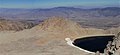
Tulainyo Lake, with Mt. Carillon's subpeak "The Cleaver" to the right. -
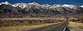 Eastern Sierra, with road pointed toward Tunnabora Peak
 -
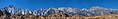 Eastern Sierra, with Tunnabora Peak centered


See also
 Mountains portal

References
- ^ a b c "Tunnabora Peak, California". Peakbagger.com. Retrieved 2021-06-12.
- ^ a b c "Tunnabora Peak - 13,563' CA". listsofjohn.com. Retrieved 2021-06-12.
- ^ a b c d "Tunnabora Peak". Geographic Names Information System. United States Geological Survey, United States Department of the Interior. Retrieved 2021-06-12.
- ^ John D. and Ruth Mendenhall, Arthur B. Johnson, Braeme Gigas, and Howard Koster, A Climber's Guide to the High Sierra (1954)
- ^ a b Francis P. Farquhar, Place Names of the High Sierra (1926)
- ^ A. L. Kroeber, California Place Names of Indian Origin, 1916, University of California Publications, page 64.
- ^ "Climate of the Sierra Nevada". Encyclopædia Britannica.
External links
- Weather forecast: Tunnabora Peak
- Tunnabora Peak photo: PBase


