Tillinghast Road Historic District
Historic district in Rhode Island, United States
United States historic place
Tillinghast Road Historic District | |
 | |
41°37′04″N 71°30′35″W / 41.6178°N 71.50983°W / 41.6178; -71.50983 | |
| Area | 160 acres (65 ha) |
|---|---|
| Built | 1972 |
| Architectural style | Greek Revival, Colonial, Federal |
| NRHP reference No. | 88000167 [1] |
| Added to NRHP | March 9, 1988 |
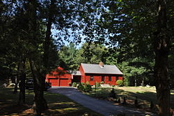
Tillinghast Road Historic District is a historic district encompassing a rural landscape in East Greenwich, Rhode Island. Extending along Tillinghast Road, a winding two-lane road, southward from its junction with Frenchtown Road, it includes seven farm complexes dating back to the late 18th and early 19th centuries. One of them, the Thomas Tillinghast Farm, located at the above-named junction, is the site of the New England Wireless and Steam Museum, some of whose buildings contribute to the district's significance.[2]
The district was listed on the National Register of Historic Places in 1988.[1]
See also
Wikimedia Commons has media related to Tillinghast Road Historic District.
References
- ^ a b "National Register Information System". National Register of Historic Places. National Park Service. January 23, 2007.
- ^ "NRHP nomination for Tillinghast Road Historic District" (PDF). Rhode Island Preservation. Retrieved September 6, 2014.
- v
- t
- e
- Architectural style categories
- Contributing property
- Historic district
- History of the National Register of Historic Places
- Keeper of the Register
- National Park Service
- Property types
- List of U.S. National Historic Landmarks by state:
- Alabama
- Alaska
- Arizona
- Arkansas
- California
- Colorado
- Connecticut
- Delaware
- Florida
- Georgia
- Hawaii
- Idaho
- Illinois
- Indiana
- Iowa
- Kansas
- Kentucky
- Louisiana
- Maine
- Maryland
- Massachusetts
- Michigan
- Minnesota
- Mississippi
- Missouri
- Montana
- Nebraska
- Nevada
- New Hampshire
- New Jersey
- New Mexico
- New York
- North Carolina
- North Dakota
- Ohio
- Oklahoma
- Oregon
- Pennsylvania
- Rhode Island
- South Carolina
- South Dakota
- Tennessee
- Texas
- Utah
- Vermont
- Virginia
- Washington
- West Virginia
- Wisconsin
- Wyoming
 National Register of Historic Places portal
 Category


| |||||||||||
|---|---|---|---|---|---|---|---|---|---|---|---|
| Topics |  | ||||||||||
| Lists by county | |||||||||||
| Lists by city |
| ||||||||||
| |||||||||||

This article about a Registered Historic Place in Kent County, Rhode Island is a stub. You can help Wikipedia by expanding it. |
- v
- t
- e


