South Thames Estuary and Marshes
Biological site in Kent
| Site of Special Scientific Interest | |
 | |
| Location | Kent |
|---|---|
| Grid reference | TQ 790 778[1] |
| Interest | Biological |
| Area | 5,289.0 hectares (13,069 acres)[1] |
| Notification | 1991[1] |
| Location map | Magic Map |
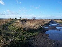
South Thames Estuary and Marshes is a 5,289-hectare (13,070-acre) biological Site of Special Scientific Interest which stretches between Gravesend and the mouth of the River Medway in Kent.[1][2] Part of it is a Nature Conservation Review site, Grade I,[3] and part is a Royal Society for the Protection of Birds nature reserve.[4] It is part of the Thames Estuary and Marshes Ramsar internationally important wetland site[5] and Special Protection Area under the European Union Directive on the Conservation of Wild Birds.[6]
The site consists of a range of habitats including mudflats, saltmarsh, grazing marsh and stretches of shingle. Inland are freshwater lagoons and some patches of deciduous woodland. Over 20,000 migratory waterfowl use this site in the winter, and some species such as greater white-fronted goose, shelduck, gadwall, teal, northern pintail, shoveler, grey plover, curlew and black-tailed godwit are present in internationally important numbers. There are also a number of breeding birds including garganey, avocet, northern pintail, bearded reedling, hen harrier, short-eared owl, ruff, common tern and European golden plover. There are nationally scarce plants on dykes and the drier parts of the site, and the saltmarsh is dominated by salt grasses, the glassworts Salicornia, sea aster, sea lavender and sea purslane. Also present are the nationally scarce plants golden samphire and Puccinellia fasciculata. The diverse invertebrates include nationally rare beetles, flies and true bugs; the scarce emerald damselfly and eight species of water beetle, including the great silver water beetle, are found here.[7]
References
- ^ a b c d "Designated Sites View: South Thames Estuary and Marshes". Sites of Special Scientific Interest. Natural England. Retrieved 28 February 2018.
- ^ "Map of South Thames Estuary and Marshes". Sites of Special Scientific Interest. Natural England. Retrieved 28 February 2018.
- ^ Ratcliffe, Derek, ed. (1977). A Nature Conservation Review. Vol. 2. Cambridge, UK: Cambridge University Press. p. 5. ISBN 0521-21403-3.
- ^ "Cliffe Pools". Royal Society for the Protection of Birds. Retrieved 22 January 2018.
- ^ "Designated Sites View: Thames Estuary and Marshes". Ramsar Site. Natural England. Retrieved 22 January 2018.
- ^ "Designated Sites View: Thames Estuary and Marshes". Special Protection Area. Natural England. Retrieved 22 January 2018.
- ^ "South Thames Estuary and Marshes citation" (PDF). Sites of Special Scientific Interest. Natural England. Retrieved 28 February 2018.
Wikimedia Commons has media related to South Thames Estuary and Marshes.
51°28′16″N 0°34′34″E / 51.471°N 0.576°E / 51.471; 0.576
- v
- t
- e
- Alex Farm Pastures
- Alkham, Lydden and Swingfield Woods
- Bourne Alder Carr
- Brookland Wood
- Charing Beech Hangers
- Chattenden Woods and Lodge Hill
- Chequer's Wood and Old Park
- Church Woods, Blean
- Cobham Woods
- Combwell Wood
- Cowden Meadow
- Cowden Pound Pastures
- Darenth Wood
- Dover to Kingsdown Cliffs
- Down Bank
- Dungeness, Romney Marsh and Rye Bay
- East Blean Woods
- Ellenden Wood
- Farningham Wood
- Folkestone to Etchinghill Escarpment
- Folkestone Warren
- Gibbin's Brook
- Great Crabbles Wood
- Great Shuttlesfield Down
- Halling to Trottiscliffe Escarpment
- Ham Street Woods
- Hatch Park
- Hoad's Wood
- Holborough to Burham Marshes
- Hollingbourne Downs
- Hothfield Common
- Ileden and Oxenden Woods
- Knole Park
- Larkey Valley Wood
- Lullingstone Park
- Lydden and Temple Ewell Downs
- Lympne Escarpment
- Lynsore Bottom
- Magpie Bottom
- Marden Meadows
- Medway Estuary and Marshes
- Northward Hill
- Oldbury and Seal Chart
- One Tree Hill and Bitchet Common
- Orlestone Forest
- Otford to Shoreham Downs
- Park Wood, Chilham
- Parkgate Down
- Parsonage Wood
- Peter's Pit
- Polebrook Farm
- Preston Marshes
- Purple Hill
- Queendown Warren
- River Beult
- Robins Wood
- Sandwich Bay to Hacklinge Marshes
- Scord's Wood and Brockhoult Mount
- Scotney Castle
- Seabrook Stream
- Sevenoaks Gravel Pits
- Sheppey Cliffs and Foreshore
- Shorne and Ashenbank Woods
- Sissinghurst Park Wood
- South Thames Estuary and Marshes
- Stodmarsh
- The Swale
- Tankerton Slopes
- Thanet Coast
- Trottiscliffe Meadows
- West Blean and Thornden Woods
- Westerham Mines
- Westerham Wood
- Wouldham to Detling Escarpment
- Wye and Crundale Downs
- Yockletts Bank
- Allington Quarry
- Aylesford Pit
- Baker's Hole
- Chequer's Wood and Old Park
- Dalham Farm
- Dover to Kingsdown Cliffs
- Dryhill
- Dungeness, Romney Marsh and Rye Bay
- Folkestone to Etchinghill Escarpment
- Folkestone Warren
- Greatness Brickworks
- Hart Hill
- High Rocks
- Houlder and Monarch Hill Pits, Upper Halling
- Hubbard's Hill
- Lenham Quarry
- Oaken Wood
- Otterpool Quarry
- Pembury Cutting and Pit
- Rusthall Common
- Sandwich Bay to Hacklinge Marshes
- Sheppey Cliffs and Foreshore
- Southborough Pit
- Spot Lane Quarry
- Sturry Pit
- Swanscombe Skull Site
- Thanet Coast
- Tower Hill to Cockham Wood
- Wansunt Pit
- Wateringbury
- Wouldham to Detling Escarpment
- Wye and Crundale Downs


