Bourne Alder Carr
Protected area in Kent, England
| Site of Special Scientific Interest | |
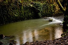 The River Bourne | |
| Location | Kent |
|---|---|
| Grid reference | TQ 606 549[1] |
| Interest | Biological |
| Area | 13.4 hectares (33 acres)[1] |
| Notification | 1987[1] |
| Location map | Magic Map |
Bourne Alder Carr is a 13.4-hectare (33-acre) biological Site of Special Scientific Interest east of Sevenoaks in Kent.[1][2]
The River Bourne runs through a shallow valley, and frequent flushing of the woodland on the banks with water rich in nutrients creates a rich ground flora. There is also an area of swamp around a fish pond.[3]
Roads and footpaths go through this site.
References
- ^ a b c d "Designated Sites View: Bourne Alder Carr". Sites of Special Scientific Interest. Natural England. Retrieved 30 January 2018.
- ^ "Map of Bourne Alder Carr". Sites of Special Scientific Interest. Natural England. Retrieved 30 January 2018.
- ^ "Bourne Alder Carr citation" (PDF). Sites of Special Scientific Interest. Natural England. Retrieved 30 January 2018.
Wikimedia Commons has media related to Bourne Alder Carr.
51°16′16″N 0°18′04″E / 51.271°N 0.301°E / 51.271; 0.301
- v
- t
- e
- Alex Farm Pastures
- Alkham, Lydden and Swingfield Woods
- Bourne Alder Carr
- Brookland Wood
- Charing Beech Hangers
- Chattenden Woods and Lodge Hill
- Chequer's Wood and Old Park
- Church Woods, Blean
- Cobham Woods
- Combwell Wood
- Cowden Meadow
- Cowden Pound Pastures
- Darenth Wood
- Dover to Kingsdown Cliffs
- Down Bank
- Dungeness, Romney Marsh and Rye Bay
- East Blean Woods
- Ellenden Wood
- Farningham Wood
- Folkestone to Etchinghill Escarpment
- Folkestone Warren
- Gibbin's Brook
- Great Crabbles Wood
- Great Shuttlesfield Down
- Halling to Trottiscliffe Escarpment
- Ham Street Woods
- Hatch Park
- Hoad's Wood
- Holborough to Burham Marshes
- Hollingbourne Downs
- Hothfield Common
- Ileden and Oxenden Woods
- Knole Park
- Larkey Valley Wood
- Lullingstone Park
- Lydden and Temple Ewell Downs
- Lympne Escarpment
- Lynsore Bottom
- Magpie Bottom
- Marden Meadows
- Medway Estuary and Marshes
- Northward Hill
- Oldbury and Seal Chart
- One Tree Hill and Bitchet Common
- Orlestone Forest
- Otford to Shoreham Downs
- Park Wood, Chilham
- Parkgate Down
- Parsonage Wood
- Peter's Pit
- Polebrook Farm
- Preston Marshes
- Purple Hill
- Queendown Warren
- River Beult
- Robins Wood
- Sandwich Bay to Hacklinge Marshes
- Scord's Wood and Brockhoult Mount
- Scotney Castle
- Seabrook Stream
- Sevenoaks Gravel Pits
- Sheppey Cliffs and Foreshore
- Shorne and Ashenbank Woods
- Sissinghurst Park Wood
- South Thames Estuary and Marshes
- Stodmarsh
- The Swale
- Tankerton Slopes
- Thanet Coast
- Trottiscliffe Meadows
- West Blean and Thornden Woods
- Westerham Mines
- Westerham Wood
- Wouldham to Detling Escarpment
- Wye and Crundale Downs
- Yockletts Bank
- Allington Quarry
- Aylesford Pit
- Baker's Hole
- Chequer's Wood and Old Park
- Dalham Farm
- Dover to Kingsdown Cliffs
- Dryhill
- Dungeness, Romney Marsh and Rye Bay
- Folkestone to Etchinghill Escarpment
- Folkestone Warren
- Greatness Brickworks
- Hart Hill
- High Rocks
- Houlder and Monarch Hill Pits, Upper Halling
- Hubbard's Hill
- Lenham Quarry
- Oaken Wood
- Otterpool Quarry
- Pembury Cutting and Pit
- Rusthall Common
- Sandwich Bay to Hacklinge Marshes
- Sheppey Cliffs and Foreshore
- Southborough Pit
- Spot Lane Quarry
- Sturry Pit
- Swanscombe Skull Site
- Thanet Coast
- Tower Hill to Cockham Wood
- Wansunt Pit
- Wateringbury
- Wouldham to Detling Escarpment
- Wye and Crundale Downs


