Sentinel Mesa
Mountain in Utah, United States


Sentinel Mesa
Location in Utah
Show map of Utah
Sentinel Mesa
Sentinel Mesa (the United States)
Show map of the United StatesSan Juan County, Utah, U.S.
Sentinel Mesa is a 6,450-foot-elevation (1,966-meter) summit in San Juan County, Utah, United States.[1] It is situated 1.5 miles (2.4 km) north of the Monument Valley visitor center on Navajo Nation land and can be seen from Highway 163. The mesa is immediately northwest of the iconic West and East Mitten Buttes. The nearest higher neighbor is Brighams Tomb, 2.64 miles (4.25 km) to the north-northeast.[2] Precipitation runoff from this mesa's west slope drains to Mitchell Butte Wash, whereas the east slope drains to West Gypsum Creek, which are both part of the San Juan River drainage basin.[3] The "Sentinel" name refers to how the mesa oversees Monument Valley which the Navajo consider as one of the "door posts" to Monument Valley.[4] The landform's toponym has been officially adopted by the U.S. Board on Geographic Names.[1]
Geology
Sentinel Mesa is a mesa composed of three principal strata. The bottom layer is Organ Rock Shale, the next stratum is De Chelly Sandstone, and the upper layer is Moenkopi Formation capped by Shinarump Conglomerate. The rock ranges in age from Permian at the bottom to Late Triassic at the top. The buttes and mesas of Monument Valley are the result of the Organ Rock Shale being more easily eroded than the overlaying sandstone.[5]
Climate
Spring and fall are the most favorable seasons to visit Sentinel Mesa. According to the Köppen climate classification system, it is located in a semi-arid climate zone with cold winters and hot summers. Summers average 54 days above 90 °F (32 °C) annually, and highs rarely exceed 100 °F (38 °C). Summer nights are comfortably cool, and temperatures drop quickly after sunset. Winters are cold, but daytime highs are usually above freezing. Winter temperatures below 0 °F (−18 °C) are uncommon, though possible. This desert climate receives less than 10 inches (250 millimeters) of annual rainfall, and snowfall is generally light during the winter.[6]
Gallery
-
 West aspect
 -
 Sentinel Mesa (left) and West Mitten Butte (right)
 -
 West aspect of Sentinel Mesa, with Big Indian to left
 -
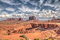
 South aspect viewed from Monument Valley Visitors Center
 -
 Sunrise on Sentinel Mesa
 -
 Southwest aspect
 -
 South aspect
 -
 Aerial view, northeast aspect
 -
 Aerial view, north aspect
 -
 Aerial view, east aspect
 -
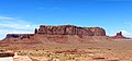
 Sentinel Mesa and West Mitten Butte
 -
 South aspect viewed from Monument Valley Visitors Center
 -
 Sentinel Mesa (left) viewed from John Ford Point
 -
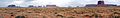 Sentinel Mesa centered in the distance
 -
 Sentinel Mesa to the left


See also
References
- ^ a b c d "Sentinel Mesa". Geographic Names Information System. United States Geological Survey, United States Department of the Interior. Retrieved 2024-08-22.
- ^ a b c d e "Sentinel Mesa - 6,460' UT". listsofjohn.com. Retrieved 2024-08-22.
- ^ a b "Sentinel Mesa, Utah". Peakbagger.com. Retrieved 2024-08-22.
- ^ Monument Valley, City of Aztec, aztecnm.com, Retrieved 2024-08-24.
- ^ Monument Valley, Arizona, Arizona Geological Survey, Retrieved 2024-08-22.
- ^ Climate Summary for Kayenta, Arizona
External links
- Weather forecast: Sentinel Mesa
- v
- t
- e
Places adjacent to Sentinel Mesa
| Highway 163 | Brighams Tomb | Big Indian |
 | ||
| Oljato–Monument Valley |  Sentinel Mesa Sentinel Mesa | West Gypsum Creek |
 | ||
| Mitchell Butte | Arizona | West Mitten Butte |
Portals:
 Geography
 Geology
 Utah
Utah


