Schiestler Peak
Mountain in the country of Canada


Schiestler Peak
Location in Wyoming
Show map of Wyoming
Schiestler Peak
Schiestler Peak (the United States)
Show map of the United StatesSchiestler Peak is an 11,624-foot-elevation (3,543-meter) mountain summit located in Sublette County of Wyoming, United States.[4]
Description
The peak is situated in the remote Wind River Range, three miles west of the Continental Divide, and approximately four miles south of the Cirque of the Towers. It is set in the Bridger Wilderness, on land managed by Bridger-Teton National Forest. Topographic relief is significant as the northeast aspect rises 2,000 feet (610 meters) in one-half mile. Nearby geographic features include Haystack Mountain, 1.9 mile to the east, Big Sandy Lake one mile north, and Temple Peak 2.3 miles to the southeast. Access to the mountain is via the Big Sandy Trail. Molybdenum was discovered on the mountain around 1940, and several claims were staked, but little ore was extracted.[6][7] Precipitation runoff from the mountain drains into headwaters of the Big Sandy River, which is a tributary of the Green River.
Etymology
The peak's name honors Felix Schiestler (1855–1924), pioneer resident of Rock Springs, Wyoming.[8] He immigrated to the United States from Austria, and after spending ten years in the east, he arrived in Rock Springs in 1886. He engaged in sheep raising, succeeding to such an extent that he was considered one of the leading flockmasters of Sweetwater County at the time of his death.[9]
Climate
According to the Köppen climate classification system, Schiestler Peak is located in an alpine subarctic climate zone with long, cold, snowy winters, and cool to warm summers.[10] Due to its altitude, it receives precipitation all year, as snow in winter, and as thunderstorms in summer.
Hazards
Encountering bears is a concern in the Wind River Range.[11] There are other concerns as well, including bugs, wildfires, adverse snow conditions and nighttime cold temperatures.[12]
Importantly, there have been notable incidents, including accidental deaths, due to falls from steep cliffs (a misstep could be fatal in this class 4/5 terrain) and due to falling rocks, over the years, including 1993,[13] 2007 (involving an experienced NOLS leader),[14] 2015[15] and 2018.[16] A 54-year-old climber from Durango fell 400–800 feet to his death from nearby Steeple Peak in 2017.[17] Other incidents include a seriously injured backpacker being airlifted near Squaretop Mountain[18] in 2005,[19] and a fatal hiker incident (from an apparent accidental fall) in 2006 that involved state search and rescue.[20] The U.S. Forest Service does not offer updated aggregated records on the official number of fatalities in the Wind River Range.
Gallery
-
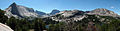 Haystack Mountain (left), Temple Peak centered in back, Schiestler Peak (right)
 -
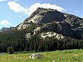 North aspect
 -
 North aspect
 -
 Left to rightː Haystack Mountain, East Temple Peak, Temple Peak, Schiestler Peak


See also
References
- ^ a b "Schiestler Peak, Wyoming". Peakbagger.com. Retrieved 2021-07-28.
- ^ Ben Adkison, Hiking Wyoming's Wind River Range, 2018, Falcon Guides, ISBN 9781493034642, page 157.
- ^ a b c "Schiestler Peak - 11,660' WY". listsofjohn.com. Retrieved 2021-07-28.
- ^ a b "Schiestler Peak". Geographic Names Information System. United States Geological Survey, United States Department of the Interior. Retrieved 2021-07-28.
- ^ Joe Kelsey, 2013, Climbing and Hiking in the Wind River Mountains, Falcon Guides, ISBN 9781493001354, page 430.
- ^ Geological Survey Bulletin, US Government Printing Office, 1971, page B33.
- ^ Schiestler Peak molybdenum prospect, Westernmininghistory.com
- ^ Orrin H. Bonney, Lorraine G. Bonney, 1965, Guide to the Wyoming Mountains and Wilderness Areas, Sage Books, page 209.
- ^ Rock Springs Rocket, January 18, 1924, wygenweb.com
- ^ Peel, M. C.; Finlayson, B. L.; McMahon, T. A. (2007). "Updated world map of the Köppen−Geiger climate classification". Hydrol. Earth Syst. Sci. 11. ISSN 1027-5606.
- ^ Staff (April 24, 2017). "Bear Safety in Wyoming's Wind River Country". WindRiver.org. Retrieved February 17, 2019.
- ^ Ballou, Dawn (July 27, 2005). "Wind River Range condition update - Fires, trails, bears, Continental Divide". PineDaleOnline News. Retrieved February 17, 2019.
- ^ Staff (1993). "Falling Rock, Loose Rock, Failure to Test Holds, Wyoming, Wind River Range, Seneca Lake". American Alpine Club. Retrieved February 15, 2019.
- ^ MacDonald, Dougald (August 14, 2007). "Trundled Rock Kills NOLS Leader". Climbing. Retrieved February 15, 2019.
- ^ Staff (December 9, 2015). "Officials rule Wind River Range climbing deaths accidental". Casper Star-Tribune. Retrieved February 15, 2019.
- ^ Dayton, Kelsey (August 24, 2018). "Deadly underestimation". WyoFile News. Retrieved February 15, 2019.
- ^ Nick Learned, Climber Falls to His Death in Wyoming’s Wind River Range, August 31, 2017, k2radio.com
- ^ Funk, Jason (2009). "Squaretop Mountain Rock Climbing". Mountain Project. Retrieved March 29, 2019.
- ^ Staff (July 22, 2005). "Injured man rescued from Square Top Mtn - Tip-Top Search & Rescue helps 2 injured on the mountain". PineDaleOnline News. Retrieved February 17, 2019.
- ^ Staff (September 1, 2006). "Incident Reports - September, 2006 - Wind River Search". WildernessDoc.com. Retrieved February 17, 2019.
External links
- Weather forecast: Schiestler Peak
- v
- t
- e
- Abiathar Peak
- Atkins Peak
- Barronette Peak
- Breccia Peak
- Clayton Mountain
- Colter Peak
- Druid Peak
- Eagle Peak
- Fortress Mountain
- Francs Peak
- Index Peak
- Mount Chittenden
- First Peoples Mountain
- Mount Hornaday
- Mount Langford
- Mount Norris
- Mount Schurz
- Mount Stevenson
- Pilot Peak
- Sheep Mesa
- The Thunderer
- Washakie Needles
- Younts Peak
| Bear Lodge Mountains | |
|---|---|
| Others |
- Antler Peak
- Bannock Peak
- Bunsen Peak
- Clagett Butte
- Dome Mountain (Park County)
- Echo Peak
- Gray Peak
- Joseph Peak
- Mount Everts
- Mount Haynes
- Mount Holmes
- Mount Jackson
- Purple Mountain
- Quadrant Mountain
- Sepulcher Mountain
- Terrace Mountain
- Three Rivers Peak
- Trilobite Point
- White Peaks
- Darwin Peak
- Doubletop Peak
- Sheep Mountain
- Elk Mountain (Carbon County)
- Medicine Bow Peak
- Albright Peak
- Battleship Mountain
- Bivouac Peak
- Buck Mountain
- Cathedral Group
- Cleaver Peak
- Cloudveil Dome
- Disappointment Peak
- Doane Peak
- Dry Ridge Mountain
- Eagles Rest Peak
- Elk Mountain (Teton County)
- Forellen Peak
- Fossil Mountain
- Grand Teton
- Green Lakes Mountain
- Housetop Mountain
- The Jaw
- Littles Peak
- Maidenform Peak
- Middle Teton
- Moose Mountain
- Mount Bannon
- Mount Glory
- Mount Hunt
- Mount Jedediah Smith
- Mount Meek
- Mount Moran
- Mount Owen
- Mount Saint John
- Mount Wister
- Mount Woodring
- Mount Woodrow Wilson
- Nez Perce Peak
- Owl Peak
- Prospectors Mountain
- Rammell Mountain
- Ranger Peak
- Raynolds Peak
- Red Mountain
- Rendezvous Mountain
- Rendezvous Peak
- Rock of Ages
- Rockchuck Peak
- Rolling Thunder Mountain
- Shadow Peak
- South Teton
- Spearhead Peak
- Static Peak
- Survey Peak
- Symmetry Spire
- Table Mountain
- Teepe Pillar
- Teewinot Mountain
- Temple Peak
- Thor Peak
- Traverse Peak
- Veiled Peak
- The Wall
- Window Peak
- American Legion Peak
- Atlantic Peak
- Bair Peak
- Bastion Peak
- Bastion Peak-Northeast Peak
- Bears Ears Mountain
- Big Sandy Mountain
- Block Tower
- Bow Mountain
- Brown Cliffs North
- Cathedral Peak
- Desolation Peak
- Dog Tooth Peak
- Dome Mountain (Hot Springs County)
- Doublet Peak
- Downs Mountain
- East Temple Peak
- Flagstone Peak (Fremont County)
- Fremont Peak
- Gannett Peak
- Harrower Peak
- Henderson Peak
- Jackson Peak
- Klondike Peak
- Knife Point Mountain
- Lander Peak
- Lizard Head Peak
- Mitchell Peak
- Mount Bonneville
- Mount Chauvenet
- Mount Febbas
- Mount Helen
- Mount Hooker
- Mount Koven
- Mount Lander
- Mount Nystrom
- Mount Owen
- Mount Sacagawea
- Mount Warren
- Mount Washakie
- Mount Whitecap
- Overhanging Tower
- Payson Peak
- Pingora Peak
- Pylon Peak
- Raid Peak
- Rampart Peak
- Roaring Fork Mountain
- Roberts Mountain
- Shale Mountain
- Sharks Nose
- South Downs Mountain
- The Sphinx
- Split Mountain
- Sunbeam Peak
- Three Waters Mountain
- Torrey Peak
- Turret Peak
- Twin Peaks
- Union Peak
- Valentine Mountain
- Valentine Peak
- War Bonnet Peak
- Warrior Peaks
- Watch Tower
- Whiskey Mountain
- Wind River Peak
- Wolfs Head
- Amethyst Mountain
- Aspen Mountain
- Barlow Peak
- Bridger Mountains
- Cook Peak
- Copper Mountain
- Dirty Mountain
- Douglas Knob
- Dunraven Peak
- Factory Hill
- Ferris Mountains
- Folsom Peak
- Garfield Peak
- Granite Mountains
- Granite Peak
- Heart Mountain
- Hedges Peak
- Hoyt Peak
- Jelm Mountain
- Mansface Hill
- Mount Hancock
- Mount Leidy
- Mount Sheridan
- Mount Washburn
- National Park Mountain
- Owl Creek Mountains
- Prospect Peak (Park County)
- Rawhide Buttes
- Roaring Mountain
- Sierra Madre Range
- Signal Mountain
- Snake River Range
- Specimen Ridge
- Sublette Mountain
- Tongue Butte
- Trischman Knob
- White Mountain
- Wilkins Peak
Portals:
 Geography
 Geology
 Mountains


