Sơn La province
Province of Vietnam
Province in Northwest, Vietnam
Sơn La province Tỉnh Sơn La | |
|---|---|
Province | |
  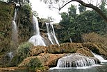      Mường La Mountain • Sơn La Dam • Dải Yếm Waterfall • Bản Phúc Mountain • Mộc Châu Mountain • Quỳnh Nhai Mountain pass • Pha Đin Mountain pass • Sơn La City | |
 Seal | |
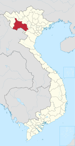 Location of Sơn La within Vietnam | |
 | |
| Coordinates: 21°10′N 104°0′E / 21.167°N 104.000°E / 21.167; 104.000 | |
| Country |  Vietnam Vietnam |
| Region | Northwest |
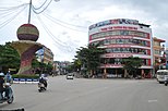
| Capital | Sơn La |
| Subdivision | 1 city, 11 rural districts |
| Government | |
| • Type | Province |
| • Body | Sơn La Provincial People's Council |
| • Chairman of People's Council | Nguyễn Thái Hưng |
| • Chairman of People's Committee | Hoàng Quốc Khánh |
| Area [1] | |
| • Province | 14,109.82 km2 (5,447.83 sq mi) |
| Population (2022)[2] | |
| • Province | 1,300,130 |
| • Density | 92/km2 (240/sq mi) |
| • Urban | 202,589 |
| Ethnic groups [3] | |
| • Thái | 53.61% |
| • Vietnamese[4] | 16.26% |
| • Mông | 16.06% |
| • Mường | 6.78% |
| • Xinh Mun | 2.17% |
| • Others | 5.12% |
| GDP[5] | |
| • Province | VND 47.223 trillion US$ 2.051 billion |
| Time zone | UTC+7 (ICT) |
| Area codes | 212 |
| ISO 3166 code | VN-05 |
| Website | www |
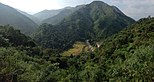
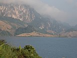
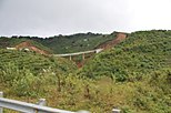
Sơn La (Vietnamese: [ʂəːn˧˧ laː˧˧] ⓘ) is a province nestled in the northwestern part of Vietnam, renowned for its stunning landscapes and rich cultural heritage. The province is characterized by rolling hills, lush valleys, and terraced rice fields that paint a mesmerizing tapestry of green hues. Home to diverse ethnic communities, including the Thai, H'Mong, and Muong people, Son La showcases a vibrant mosaic of traditions and customs.
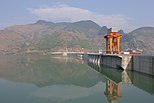
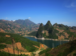
Sơn La Dam, the largest hydroelectric power station in Southeast Asia.[6] is located in this province.
Administrative divisions

Sơn La is subdivided into 12 district-level sub-divisions and 204 commune-level sub-divisions:
| Administrative divisions of Sơn La | ||||||||||||||||||||||||||||||||||||||||||||||||||||||||||||||||||
|---|---|---|---|---|---|---|---|---|---|---|---|---|---|---|---|---|---|---|---|---|---|---|---|---|---|---|---|---|---|---|---|---|---|---|---|---|---|---|---|---|---|---|---|---|---|---|---|---|---|---|---|---|---|---|---|---|---|---|---|---|---|---|---|---|---|---|
|
| |||||||||||||||||||||||||||||||||||||||||||||||||||||||||||||||||
See also
- Nà Sản Airport
- Mộc Châu plateau
References
- ^ Biểu số 4.1: Hiện trạng sử dụng đất vùng Trung du và miền núi phía Bắc năm 2022 [Table 4.1: Current land use status in the Northern Midlands and Mountains in 2022] (PDF) (Decision 3048/QĐ-BTNMT) (in Vietnamese). Ministry of Natural Resources and Environment (Vietnam). 18 October 2023. – the data in the report are in hectares, rounded to integers
- ^ "Area, population and population density by province". General Statistics Office of Vietnam. Retrieved 12 April 2024. – Interactive table which you can view by making your selection in three boxes: (1) Cities, provinces: Select all; (2) Year: Select 2022; (3) Items: Select all.
- ^ General Statistics Office of Vietnam (2019). "Completed Results of the 2019 Viet Nam Population and Housing Census" (PDF). Statistical Publishing House (Vietnam). ISBN 978-604-75-1532-5.
- ^ Also called Kinh people
- ^ "Tình hình kinh tế, xã hội Sơn La năm 2018". Cục Thống kê tỉnh Sơn La. Retrieved 10 May 2020.
- ^ "Huge hydro plant starts operation in Vietnam, says official". Intellasia News Services. 2010-12-22. Retrieved 2011-01-22.
External links
- Official website
Places adjacent to Sơn La province | |
|---|---|


- v
- t
- e
- Northeast
- Northwest
- Red River Delta
- North Central Coast
- South Central Coast
- Central Highlands
- Southeast
- Mekong Delta
- An Giang
- Bà Rịa–Vũng Tàu
- Bắc Giang
- Bắc Kạn
- Bạc Liêu
- Bắc Ninh
- Bến Tre
- Bình Định
- Bình Dương
- Bình Phước
- Bình Thuận
- Cà Mau
- Cao Bằng
- Đắk Lắk
- Đắk Nông
- Điện Biên
- Đồng Nai
- Đồng Tháp
- Gia Lai
- Hà Giang
- Hà Nam
- Hà Tĩnh
- Hải Dương
- Hậu Giang
- Hòa Bình
- Hưng Yên
- Khánh Hòa
- Kiên Giang
- Kon Tum
- Lai Châu
- Lâm Đồng
- Lạng Sơn
- Lào Cai
- Long An
- Nam Định
- Nghệ An
- Ninh Bình
- Ninh Thuận
- Phú Thọ
- Phú Yên
- Quảng Bình
- Quảng Nam
- Quảng Ngãi
- Quảng Ninh
- Quảng Trị
- Sóc Trăng
- Sơn La
- Tây Ninh
- Thái Bình
- Thái Nguyên
- Thanh Hóa
- Thừa Thiên Huế
- Tiền Giang
- Trà Vinh
- Tuyên Quang
- Vĩnh Long
- Vĩnh Phúc
- Yên Bái
- District level subdivisions
- Commune level subdivisions
- List of cities
Authority control databases | |
|---|---|
| International |
|
| National |
|
| Other |
|
 | This article about a location in Sơn La Province, Vietnam is a stub. You can help Wikipedia by expanding it. |
- v
- t
- e


