Puiflijk
Village in Gelderland, Netherlands
Puiflijk Pufluk | |
|---|---|
Village | |
 Centre of the village | |
51°53′N 5°35′E / 51.883°N 5.583°E / 51.883; 5.583 | |
| Country | Netherlands |
| Province | Gelderland |
| Municipality | Druten |
| Area [1] | |
| • Total | 5.54 km2 (2.14 sq mi) |
| Population (2021)[1] | |
| • Total | 1,290 |
| • Density | 230/km2 (600/sq mi) |
| Time zone | UTC+1 (CET) |
| • Summer (DST) | UTC+2 (CEST) |
| Postal code | 6655[1] |
| Dialing code | 026 |
Puiflijk is a village in the Dutch province of Gelderland. It is a part of the municipality of Druten, and lies about 12 km south of Wageningen.
Puiflijk was a separate municipality until 1818, when it was merged with Druten.[2]
History
It was first mentioned in 1108 as Puueke. The etymology is unknown.[3] The village is located on some small hills.[4] The Old Tower is a church tower from the 15th century.[4] The church was heavy damaged around 1800 during the French occupation, and was demolished in 1855 leaving only the tower.[5] The St. John the Baptist church was built between 1868 and 1870.[4]
The area around Puiflijk was suitable for growing tobacco, and a tobacco industry developed in the village.[5] In 1840, Puiflijk was home to 468 people.[5]
Gallery
-
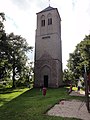 Church tower
 -
 House in Puiflijk
 -
 The tobacco cutter by Humprey Dirks
 -
 John the Baptist Church


References
- ^ a b c "Kerncijfers wijken en buurten 2021". Central Bureau of Statistics. Retrieved 21 March 2022.
- ^ Ad van der Meer and Onno Boonstra, Repertorium van Nederlandse gemeenten, KNAW, 2011.
- ^ "Puiflijk - (geografische naam)". Etymologiebank (in Dutch). Retrieved 21 March 2022.
- ^ a b c Ronald Stenvert & Sabine Broekhoven (2000). "Druten" (in Dutch). Zwolle: Waanders. p. 153. ISBN 90 400 9406 3. Retrieved 21 March 2022.
- ^ a b c "Puiflijk". Plaatsengids (in Dutch). Retrieved 21 March 2022.
 | This Gelderland location article is a stub. You can help Wikipedia by expanding it. |
- v
- t
- e


