Pir Kuh-e Olya
Village in Gilan province, Iran
Village in Gilan, Iran
Pir Kuh-e Olya Persian: پيركوه عليا | |
|---|---|
Village | |
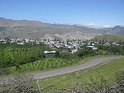 The village of Pir Kuh-e Olya | |
| 36°49′32″N 50°00′36″E / 36.82556°N 50.01000°E / 36.82556; 50.01000[1] | |
| Country | Iran |
| Province | Gilan |
| County | Siahkal |
| District | Deylaman |
| Rural District | Pir Kuh |
| Population (2016)[2] | |
| • Total | 588 |
| Time zone | UTC+3:30 (IRST) |
Pir Kuh-e Olya (Persian: پيركوه عليا)[a] is a village in, and the capital of, Pir Kuh Rural District[4] of Deylaman District, Siahkal County, Gilan province, Iran.
Demographics
Population
At the time of the 2006 National Census, the village's population was 661 in 201 households.[5] The following census in 2011 counted 541 people in 177 households.[6] The 2016 census measured the population of the village as 588 people in 203 households. It was the most populous village in its rural district.[2]
See also
 Iran portal
Notes
References
- ^ OpenStreetMap contributors (9 October 2023). "Pir Kuh-e Olya, Siahkal County" (Map). OpenStreetMap (in Persian). Retrieved 9 October 2023.
- ^ a b "Census of the Islamic Republic of Iran, 1395 (2016)". AMAR (in Persian). The Statistical Center of Iran. p. 01. Archived from the original (Excel) on 4 December 2020. Retrieved 19 December 2022.
- ^ Pir Kuh-e Olya can be found at GEOnet Names Server, at this link, by opening the Advanced Search box, entering "-3078334" in the "Unique Feature Id" form, and clicking on "Search Database".
- ^ Mousavi, Mirhossein (18 May 1366). "Creation and formation of 10 rural districts including villages, farms and places in Rudbar County under Gilan province". Research Center of the System of Laws of the Islamic Council of the Farabi Library of Mobile Users (in Persian). Ministry of Interior, Council of Ministers. Archived from the original on 5 April 2013. Retrieved 13 December 2023.
- ^ "Census of the Islamic Republic of Iran, 1385 (2006)". AMAR (in Persian). The Statistical Center of Iran. p. 01. Archived from the original (Excel) on 20 September 2011. Retrieved 25 September 2022.
- ^ "Census of the Islamic Republic of Iran, 1390 (2011)". Syracuse University (in Persian). The Statistical Center of Iran. p. 01. Archived from the original (Excel) on 8 October 2023. Retrieved 19 December 2022.
- v
- t
- e


- Alshaytan Mountain
- Anzali Lagoon
- Astarachay
- Anzali Maritime Museum
- Laton Waterfall
- Astara Cactus museum
- Emarat-i Kulah Farangi Rasht
- Estil Lagoon
- Ghaziayan bridge
- Heyran road
- Heyran Gondola lift
- Rasht Municipality (city hall)
- Roudkhan Castle
- Sajiran waterfall
- Lunak waterfall
- Marlik royal cemetery
- Masouleh
- Moin Mausoleum
- Muhtasham garden
- Kull ancient castle
- Rasht museum
- Sheitankoh
- Tea Museum of Lahijan
- Zahed Gilani's Shrine
- Tea museum
 | This Siahkal County location article is a stub. You can help Wikipedia by expanding it. |
- v
- t
- e


