Pescocostanzo
Comune in Abruzzo, Italy
Location of Pescocostanzo

41°53′14″N 14°3′59″E / 41.88722°N 14.06639°E / 41.88722; 14.06639
(1 January 2007)[2]
67033
Pescocostanzo is a comune and town of 1038 inhabitants in the Province of L'Aquila in the Abruzzo region of Italy. It is a tourist destination, attracting people from all over Italy due to its landscape and environment.[citation needed] It is part of the Maiella National Park and is one of I Borghi più belli d'Italia ("The most beautiful villages of Italy").[3] In winter, Pescocostanzo is a destination for skiers and snowboarders, and has its own ski resort. The towns of Roccaraso and Rivisondoli are close by.
Images
-
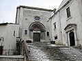 Basilica della Madonna del Colle
 -
 Palazzo Fanzago


Climate
| Climate data for Pescocostanzo, elevation 1,395 m (4,577 ft), (1951–2000) | |||||||||||||
|---|---|---|---|---|---|---|---|---|---|---|---|---|---|
| Month | Jan | Feb | Mar | Apr | May | Jun | Jul | Aug | Sep | Oct | Nov | Dec | Year |
| Record high °C (°F) | 14.2 (57.6) | 17.0 (62.6) | 19.2 (66.6) | 21.5 (70.7) | 26.5 (79.7) | 30.0 (86.0) | 33.5 (92.3) | 33.5 (92.3) | 30.5 (86.9) | 23.5 (74.3) | 19.9 (67.8) | 17.1 (62.8) | 33.5 (92.3) |
| Mean daily maximum °C (°F) | 3.2 (37.8) | 4.2 (39.6) | 6.7 (44.1) | 9.9 (49.8) | 14.6 (58.3) | 18.4 (65.1) | 21.5 (70.7) | 21.8 (71.2) | 17.8 (64.0) | 12.9 (55.2) | 7.8 (46.0) | 4.5 (40.1) | 11.9 (53.5) |
| Daily mean °C (°F) | 0.2 (32.4) | 0.7 (33.3) | 3.0 (37.4) | 5.9 (42.6) | 10.3 (50.5) | 13.9 (57.0) | 16.7 (62.1) | 16.8 (62.2) | 13.5 (56.3) | 9.1 (48.4) | 4.7 (40.5) | 1.5 (34.7) | 8.0 (46.5) |
| Mean daily minimum °C (°F) | −2.6 (27.3) | −2.7 (27.1) | −0.8 (30.6) | 2.0 (35.6) | 6.1 (43.0) | 9.5 (49.1) | 11.8 (53.2) | 11.7 (53.1) | 9.1 (48.4) | 5.3 (41.5) | 1.6 (34.9) | −1.4 (29.5) | 4.1 (39.4) |
| Record low °C (°F) | −18.5 (−1.3) | −15.6 (3.9) | −14.5 (5.9) | −10.2 (13.6) | −5.5 (22.1) | 0.0 (32.0) | 1.2 (34.2) | 2.0 (35.6) | −2.0 (28.4) | −7.0 (19.4) | −12.0 (10.4) | −18.8 (−1.8) | −18.8 (−1.8) |
| Average precipitation mm (inches) | 98.4 (3.87) | 85.3 (3.36) | 78.9 (3.11) | 77.1 (3.04) | 66.7 (2.63) | 53.5 (2.11) | 53.0 (2.09) | 45.4 (1.79) | 68.0 (2.68) | 90.2 (3.55) | 113.2 (4.46) | 112.8 (4.44) | 942.5 (37.13) |
| Average precipitation days | 9.0 | 9.0 | 8.3 | 9.5 | 9.6 | 7.4 | 5.9 | 5.4 | 6.9 | 9.1 | 10.1 | 9.8 | 100 |
| Source: Regione Abruzzo[4] | |||||||||||||
See also
References
- ^ "Superficie di Comuni Province e Regioni italiane al 9 ottobre 2011". Italian National Institute of Statistics. Retrieved 16 March 2019.
- ^ ISTAT. "Monthly demographic balance January-November 2008". Retrieved 2009-04-27.
- ^ "Abruzzo" (in Italian). Retrieved 1 August 2023.
- ^ "VALORI MEDI CLIMATICI DAL 1951 AL 2000 NELLA REGIONE ABRUZZO" (PDF). Regione Abruzzo. Archived from the original (PDF) on 30 June 2024. Retrieved 30 June 2024.
External links
Wikimedia Commons has media related to Pescocostanzo.
- I Borghi più belli d'Italia (it / en)
- Pescocostanzo Portal (it)
- Abruzzo Ski World Cup (it)
- (it)
- v
- t
- e
- Acciano
- Aielli
- Alfedena
- Anversa degli Abruzzi
- Ateleta
- Avezzano
- Balsorano
- Barete
- Barisciano
- Barrea
- Bisegna
- Bugnara
- Cagnano Amiterno
- Calascio
- Campo di Giove
- Campotosto
- Canistro
- Cansano
- Capestrano
- Capistrello
- Capitignano
- Caporciano
- Cappadocia
- Carapelle Calvisio
- Carsoli
- Castel del Monte
- Castel di Ieri
- Castel di Sangro
- Castellafiume
- Castelvecchio Calvisio
- Castelvecchio Subequo
- Celano
- Cerchio
- Civita d'Antino
- Civitella Alfedena
- Civitella Roveto
- Cocullo
- Collarmele
- Collelongo
- Collepietro
- Corfinio
- Fagnano Alto
- Fontecchio
- Fossa
- Gagliano Aterno
- Gioia dei Marsi
- Goriano Sicoli
- Introdacqua
- L'Aquila
- Lecce nei Marsi
- Luco dei Marsi
- Lucoli
- Magliano de' Marsi
- Massa d'Albe
- Molina Aterno
- Montereale
- Morino
- Navelli
- Ocre
- Ofena
- Opi
- Oricola
- Ortona dei Marsi
- Ortucchio
- Ovindoli
- Pacentro
- Pereto
- Pescasseroli
- Pescina
- Pescocostanzo
- Pettorano sul Gizio
- Pizzoli
- Poggio Picenze
- Prata d'Ansidonia
- Pratola Peligna
- Prezza
- Raiano
- Rivisondoli
- Rocca Pia
- Rocca di Botte
- Rocca di Cambio
- Rocca di Mezzo
- Roccacasale
- Roccaraso
- San Benedetto dei Marsi
- San Benedetto in Perillis
- San Demetrio ne' Vestini
- San Pio delle Camere
- San Vincenzo Valle Roveto
- Sant'Eusanio Forconese
- Sante Marie
- Santo Stefano di Sessanio
- Scanno
- Scontrone
- Scoppito
- Scurcola Marsicana
- Secinaro
- Sulmona
- Tagliacozzo
- Tione degli Abruzzi
- Tornimparte
- Trasacco
- Villa Sant'Angelo
- Villa Santa Lucia degli Abruzzi
- Villalago
- Villavallelonga
- Villetta Barrea
- Vittorito
| Authority control databases |
|
|---|
 | This Abruzzo location article is a stub. You can help Wikipedia by expanding it. |
- v
- t
- e


