Onogur Islands
62°21′07″S 59°41′00″W / 62.35194°S 59.68333°W / -62.35194; -59.68333
Onogur Islands (Bulgarian: Оногурски острови, ‘Onogurski ostrovi’ \o-no-'gur-ski 'os-tro-vi\) is the group of nine islands and some islets and rocks adjacent to the northwest coast of Robert Island in the South Shetland Islands, Antarctica. The group is situated between Carlota Cove to the southwest and Clothier Harbour to the northeast, and 700 m (770 yd) southeast of Cornwall Island. Kovach Island and Grod Island, the largest two in the group, have a surface area of 11 hectares (27 acres) and 10 hectares (25 acres) respectively.[1] The area was visited by early 19th century sealers based in Clothier Harbour.
The island group is named after the settlement of Onogur in northeastern Bulgaria in connection with the Onogurs (5th-7th century).
Islands in the Onogur group
The group comprises the following islands:
- Churicheni Island
- Grod Island
- Kovach Island
- Leeve Island
- Oescus Island
- Osenovlag Island
- Redina Island
- Svetulka Island
- Vilare Island
Location
Onogur Islands are centred at 62°21′07″S 59°41′00″W / 62.35194°S 59.68333°W / -62.35194; -59.68333. British mapping in 1822 and 1968, Chilean in 1971, Argentine in 1980, and Bulgarian in 2009.
Maps
- Livingston Island to King George Island. Scale 1:200000. Admiralty Nautical Chart 1776. Taunton: UK Hydrographic Office, 1968.
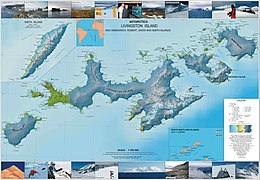
- L.L. Ivanov. Antarctica: Livingston Island and Greenwich, Robert, Snow and Smith Islands. Scale 1:120000 topographic map. Troyan: Manfred Wörner Foundation, 2010. ISBN 978-954-92032-9-5 (First edition 2009. ISBN 978-954-92032-6-4)
- Antarctic Digital Database (ADD). Scale 1:250000 topographic map of Antarctica. Scientific Committee on Antarctic Research (SCAR). Since 1993, regularly upgraded and updated.
- L.L. Ivanov. Antarctica: Livingston Island and Smith Island. Scale 1:100000 topographic map. Manfred Wörner Foundation, 2017. ISBN 978-619-90008-3-0
See also
- Composite Antarctic Gazetteer
- List of Antarctic islands south of 60° S
- SCAR
- Territorial claims in Antarctica
Notes
- ^ L.L. Ivanov. Antarctica: Livingston Island and Greenwich, Robert, Snow and Smith Islands. Scale 1:120000 topographic map. Troyan: Manfred Wörner Foundation, 2010. ISBN 978-954-92032-9-5 (First edition 2009. ISBN 978-954-92032-6-4)
References
- Onogur Islands. SCAR Composite Antarctic Gazetteer
- Bulgarian Antarctic Gazetteer. Antarctic Place-names Commission. (details in Bulgarian, basic data in English)
External links
- Onogur Islands. Copernix satellite image
This article includes information from the Antarctic Place-names Commission of Bulgaria which is used with permission.
Portals:
 Islands
 Geography


- v
- t
- e
- Clarence
- Deception
- Elephant
- Greenwich
- King George
- Livingston
- Low
- Nelson
- Robert
- Smith
- Snow
- Afala
- Aitcho
- Akin
- Alfeus
- Araguez
- Astor
- Aurelia
- Barlow
- Basso
- Beslen
- Biruni
- Boatin
- Borceguí
- Bridgeman
- Cacho
- Chiprovtsi
- Cornwall
- Cornwallis
- Craggy
- Dee
- Desolation Island (South Shetland Islands)
- Dinea
- Dioptra
- Dufayel
- Dunbar
- Eadie
- Express
- Fregata
- Gergini
- Gibbs
- Glumche
- Gnomon
- González
- Half Moon
- Heywood
- Kabile
- Kaliman
- Kondor
- Korsis
- Låvebrua
- Meade
- Miladinovi
- Montufar
- Ogygia
- Ongley
- Onogur
- Penguin
- Pindarev
- Pordim
- Presnakov
- Prisad
- Prosechen
- Pyramid
- Rogozen
- Romeo
- Rotalia
- Rowett
- Rugged
- Saffar
- San Telmo
- Seal
- Sierra
- Square End
- Stoker
- Sugarloaf
- Table
- Tatul
- Tirizis
- Toledo
- Treklyano
- Two Summit
- Valchedram
- Window
- Withem
- Wood
- Yrvind
- Zebil
- Zed
Rocks, stacks, reefs
spits and banks
spits and banks
- Aim Rocks
- Alepu
- Avren
- Baktriana
- Ballestilla
- Bekas
- Belchin
- Besson
- Bizone
- Bonert
- Borda
- Bowler
- Brahe
- Bris
- Buchino
- Caraquet
- Chabrier
- Channel
- Chaos
- Chapman
- Cheshire
- Chorobates
- Cone
- Cosmolabe
- Cove
- Cutler
- Dlagnya
- Dovizio
- Dzhegov
- Eddystone
- Elemag
- Eliza
- Emm
- Enchantress
- Folger
- Frederick
- Galiche
- Glozhene
- Goritsa
- Grace
- Graovo
- Groma
- Growler
- Habermehl
- Hauken
- Henfield
- Hetty
- Hole
- Holmes
- Ibar
- Indian
- Keep
- Kianida
- Knight
- Koynare
- Lenoir
- Letelier
- Liberty
- Lientur
- Limit
- Livonia
- Long
- Low
- Lynx
- Lyutibrod
- Maglizh
- Makresh
- Martello Tower
- Meldia
- Mellona
- Milev
- Mónica
- Morris
- Nancy
- Napier
- Nessie
- Nikudin
- Odometer
- Okol
- Opaka
- Ørnen
- Orsini
- Orsoya
- Parry Patch
- Passage
- Patresh
- Perivol
- Pig
- Pingvin
- Potmess
- Asses Ears
- Priboy
- Rabisha
- Ramsden
- Raquelia
- Reyes
- Ritchie
- Rongel
- Rosales
- Rusokastro
- Sail Rock
- Salient
- Sally
- Sewing-Machine Needles
- Shearer
- Simms
- Simpson
- Sinbad
- Skrino
- Stackpole
- Stewart
- Suhache
- Syrezol
- Telefon
- Telish
- Tenorio
- The Pointers
- Tooth
- Triznatsi
- Troughton
- Tu
- Turmoil
- Tvarditsa
- Twin Pinnacles
- Upton
- Vardim
- Vergilov
- Vidal
- Vietor
- Vodoley
- Voluyak
- Waldseemüller
- Weeks
Undersea and
subglacial features
subglacial features
| ||||||||
|---|---|---|---|---|---|---|---|---|
| Geography |
|  | ||||||
| History | ||||||||
| Politics | ||||||||
| Society | ||||||||
| Famous explorers | ||||||||
| ||||||||

 | This Robert Island location article is a stub. You can help Wikipedia by expanding it. |
- v
- t
- e


