Nuʻutele
Island in Atua District, Samoa
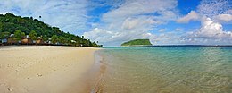 Nuʻutele island viewed from Lalomanu beach, 2007 | |
 | |
| Geography | |
|---|---|
| Area | 1.15 km2 (0.44 sq mi) |
| Coastline | 5.04 km (3.132 mi) |

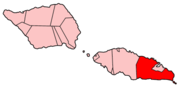
Nuʻutele is an island that consists of a volcanic tuff ring. It lies 1.3 km off the eastern end of Upolu island, Samoa, in central South Pacific Ocean. It is the largest of the four Aleipata Islands, with an area of 1.15 km2 (0.44 sq mi).
Nuʻutele, together with Nuʻulua, a smaller island in the Aleipata group, are significant conservation areas for native species of bird life. Nuʻutele features steep terrain, with vertical marine cliffs up to 180 m high.[1]
Nuʻutele is famous as a highly appreciated scenic landmark when viewed in the distance from the popular Lalomanu beach area on nearby Upolu Island, across the water.

See also
 Islands portal

- Samoa Islands
- List of islands
- Desert island
Notes
- "Upolu". Global Volcanism Program. Smithsonian Institution. (includes Nu'utele)
- Some information about Nu'utele and Nu'ulua.
References
- ^ [1] Pacific Cooperative Islands Initiative. Retrieved 26 October 2009
- v
- t
- e
 Atua District: Itūmālō
Traditional center: Lufilufi
- Nu'usafe'e Island
- Aleipata Islands (uninhabited, conservation areas):
- Nu'utele
- Nu'ulua
- Namua
- Fanuatapu
- Aleipata Itupa i Lalo
- Aleipata Itupa i Luga
- Anoamaa East
- Anoamaa West
- Falealili (2 seats)
- Lepa
- Lotofaga
14°03′47″S 171°25′23″W / 14.063°S 171.423°W / -14.063; -171.423
 | This article about a geographical location in Samoa is a stub. You can help Wikipedia by expanding it. |
- v
- t
- e


