National Register of Historic Places listings in Yosemite National Park
This is a list of the National Register of Historic Places listings in Yosemite National Park.
This is intended to be a complete list of the properties and districts on the National Register of Historic Places in Yosemite National Park, California, United States. The locations of National Register properties and districts for which the latitude and longitude coordinates are included below, may be seen in a Google map.[1]
There are 46 properties and districts listed on the National Register in the park and five National Historic Landmarks. Four more properties associated with the park are located just outside the park boundaries.
This National Park Service list is complete through NPS recent listings posted September 13, 2024.[2]
Map all coordinates using OpenStreetMap
Download coordinates as:
- KML
- GPX (all coordinates)
- GPX (primary coordinates)
- GPX (secondary coordinates)
Current listings
| [3] | Name on the Register[4] | Image | Date listed[5] | Location | City or town | Description |
|---|---|---|---|---|---|---|
| 1 | Acting Superintendent's Headquarters |  | June 9, 1978 (#78000362) | Pioneer Yosemite History Center 37°32′20″N 119°39′17″W / 37.538889°N 119.654722°W / 37.538889; -119.654722 (Acting Superintendent's Headquarters) | Wawona | |
| 2 | Ahwahnee Hotel | 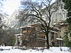 | February 15, 1977 (#77000149) | 1 Ahwahnee Drive, Yosemite Valley 37°44′45″N 119°34′22″W / 37.745833°N 119.572778°W / 37.745833; -119.572778 (Ahwahnee Hotel) | Yosemite National Park | |
| 3 | Buck Camp Patrol Cabin |  | July 18, 2014 (#14000406) | Jct. of Buck Cr. & Buck Camp Tr. 37°33′47″N 119°29′23″W / 37.562991°N 119.489592°W / 37.562991; -119.489592 (Buck Camp Patrol Cabin) | Yosemite National Park | |
| 4 | Camp 4 |  | February 21, 2003 (#03000056) | Northside Dr., Yosemite Valley 37°44′30″N 119°36′09″W / 37.741667°N 119.6025°W / 37.741667; -119.6025 (Camp 4) | Yosemite National Park | |
| 5 | Camp Curry Historic District |  | November 1, 1979 (#79000315) | Curry Village, Yosemite Valley 37°44′36″N 119°34′16″W / 37.743333°N 119.571111°W / 37.743333; -119.571111 (Camp Curry Historic District) | Yosemite National Park | |
| 6 | Crane Flat Fire Lookout |  | April 4, 1996 (#96000354) | North of Big Oak Flat Rd., near Crane Cr., Yosemite National Park 37°45′34″N 119°49′10″W / 37.759444°N 119.819444°W / 37.759444; -119.819444 (Crane Flat Fire Lookout) | Aspen Valley | part of the Historic Park Landscapes in National and State Parks Multiple Property Submission (MPS) |
| 7 | Degnan's Restaurant |  | September 5, 2017 (#100001558) | 9001 Village Dr., Yosemite Village 37°44′53″N 119°35′08″W / 37.748079°N 119.585526°W / 37.748079; -119.585526 (Degnan's Restaurant) | Yosemite National Park | |
| 8 | Frog Creek Cabin |  | July 18, 2014 (#14000414) | South shore of Lake Eleanor, along Frog Creek 37°58′59″N 119°50′37″W / 37.983127°N 119.843480°W / 37.983127; -119.843480 (Frog Creek Cabin) | Yosemite National Park | 1936-built cabin, used originally to support trout egg collection |
| 9 | Glacier Point Trailside Museum |  | April 4, 1978 (#78000357) | Glacier Point 37°43′50″N 119°34′23″W / 37.730556°N 119.573056°W / 37.730556; -119.573056 (Glacier Point Trailside Museum) | Yosemite National Park | |
| 10 | Glen Aulin High Sierra Camp |  | July 18, 2014 (#14000415) | At confluence of Tuolumne River and Alkali Creek 37°54′32″N 119°25′08″W / 37.908812°N 119.418772°W / 37.908812; -119.418772 (Glen Aulin High Sierra Camp) | Yosemite National Park | |
| 11 | Great Sierra Mine Historic Site |  | May 24, 1978 (#78000382) | Southwest of Lee Vining 37°55′39″N 119°16′05″W / 37.9275°N 119.268056°W / 37.9275; -119.268056 (Great Sierra Mine Historic Site) | Yosemite National Park | |
| 12 | Great Sierra Wagon Road |  | August 25, 1978 (#78000373) | Northwest of Yosemite Valley 37°50′32″N 119°43′20″W / 37.842222°N 119.722222°W / 37.842222; -119.722222 (Great Sierra Wagon Road) | Yosemite National Park | |
| 13 | Half Dome Cables and Trail |  | August 15, 2012 (#12000494) | P.O. Box 577 37°44′49″N 119°31′47″W / 37.746863°N 119.529669°W / 37.746863; -119.529669 (Half Dome Cables and Trail) | Yosemite National Park | |
| 14 | Hodgdon Homestead Cabin | 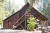 | June 9, 1978 (#78000356) | Pioneer Yosemite History Center 37°32′20″N 119°39′19″W / 37.538889°N 119.655278°W / 37.538889; -119.655278 (Hodgdon Homestead Cabin) | Wawona | |
| 15 | Chris Jorgensen Studio |  | April 13, 1979 (#79000280) | Pioneer Yosemite History Center 37°32′20″N 119°39′19″W / 37.538889°N 119.655278°W / 37.538889; -119.655278 (Chris Jorgensen Studio) | Wawona | |
| 16 | Lake Vernon Snow Survey Shelter | Upload image | July 18, 2014 (#14000416) | Terminus of Lake Vernon Tr. 38°01′10″N 119°42′55″W / 38.019422°N 119.715244°W / 38.019422; -119.715244 (Lake Vernon Snow Survey Shelter) | Yosemite National Park | |
| 17 | LeConte Memorial Lodge |  | March 8, 1977 (#77000148) | Yosemite Valley 37°44′24″N 119°34′42″W / 37.74°N 119.578333°W / 37.74; -119.578333 (LeConte Memorial Lodge) | Yosemite National Park | |
| 18 | Mariposa Grove Museum | 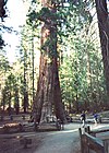 | December 1, 1978 (#78000381) | Southeast of Wawona 37°30′50″N 119°35′54″W / 37.513889°N 119.598333°W / 37.513889; -119.598333 (Mariposa Grove Museum) | Yosemite National Park | |
| 19 | May Lake High Sierra Camp | Upload image | July 18, 2014 (#14000417) | Eastern shore of May Lake 37°50′42″N 119°29′28″W / 37.844924°N 119.490996°W / 37.844924; -119.490996 (May Lake High Sierra Camp) | Yosemite National Park | |
| 20 | McCauley Cabin |  | March 8, 1977 (#77000359) | Tuolumne Meadows 37°52′40″N 119°22′01″W / 37.877778°N 119.366944°W / 37.877778; -119.366944 (McCauley Cabin) | Yosemite National Park | |
| 21 | McCauley and Meyer Barns |  | June 15, 1978 (#78000353) | North of El Portal 37°42′00″N 119°45′18″W / 37.7°N 119.755°W / 37.7; -119.755 (McCauley and Meyer Barns) | Yosemite National Park | |
| 22 | McGurk Cabin | 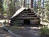 | June 4, 1979 (#79000281) | South of Yosemite Valley 37°40′40″N 119°37′27″W / 37.677778°N 119.624167°W / 37.677778; -119.624167 (McGurk Cabin) | Yosemite National Park | |
| 23 | Merced Grove Ranger Station |  | June 15, 1978 (#78000358) | North of El Portal 37°44′56″N 119°50′21″W / 37.748889°N 119.839167°W / 37.748889; -119.839167 (Merced Grove Ranger Station) | Yosemite National Park | |
| 24 | Merced Lake High Sierra Camp | Upload image | July 18, 2014 (#14000407) | Along north bank of Merced River, directly east of Merced Lake 37°44′24″N 119°24′24″W / 37.739928°N 119.406544°W / 37.739928; -119.406544 (Merced Lake High Sierra Camp) | Yosemite National Park | |
| 25 | Merced Lake Ranger Station | Upload image | July 18, 2014 (#14000408) | Jct. of Merced Lake Tr. & Lewis Cr. 37°44′18″N 119°23′45″W / 37.738261°N 119.395709°W / 37.738261; -119.395709 (Merced Lake Ranger Station) | Yosemite National Park | |
| 26 | Ostrander Lake Ski Hut | 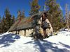 | July 18, 2014 (#14000409) | Ostrander Lake Tr. 37°37′36″N 119°32′59″W / 37.626778°N 119.549753°W / 37.626778; -119.549753 (Ostrander Lake Ski Hut) | Yosemite National Park | |
| 27 | Parsons Memorial Lodge |  | April 30, 1979 (#79000283) | Tuolumne Meadows 37°52′42″N 119°22′00″W / 37.878333°N 119.366667°W / 37.878333; -119.366667 (Parsons Memorial Lodge) | Yosemite National Park | |
| 28 | Rangers' Club |  | May 28, 1987 (#87001414) | Yosemite Village 37°44′50″N 119°35′12″W / 37.747222°N 119.586667°W / 37.747222; -119.586667 (Rangers' Club) | Yosemite National Park | |
| 29 | Sachse Spring Snow Survey Shelter | Upload image | July 18, 2014 (#14000418) | Off Kibbie Ridge Tr. near Sachse Spring 38°04′51″N 119°50′34″W / 38.080825°N 119.842905°W / 38.080825; -119.842905 (Sachse Spring Snow Survey Shelter) | Yosemite National Park | |
| 30 | Snow Creek Ski Hut | Upload image | July 18, 2014 (#14000410) | Off Tenaya Lake Trail, westerly shoulder of Mt. Watkins 37°47′17″N 119°31′22″W / 37.787980°N 119.522663°W / 37.787980; -119.522663 (Snow Creek Ski Hut) | Yosemite National Park | |
| 31 | Snow Flat Snow Survey Shelter | Upload image | July 18, 2014 (#14000411) | Terminus of service road off May Lake Rd. 37°49′31″N 119°29′52″W / 37.825332°N 119.497667°W / 37.825332; -119.497667 (Snow Flat Snow Survey Shelter) | Yosemite National Park | |
| 32 | Soda Springs Cabin | 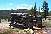 | April 19, 1979 (#79000282) | Tuolumne Meadows 37°52′44″N 119°21′56″W / 37.878889°N 119.365556°W / 37.878889; -119.365556 (Soda Springs Cabin) | Yosemite National Park | |
| 33 | Sunrise High Sierra Camp | Upload image | July 18, 2014 (#14000412) | Along north bank of Long Meadow Creek, overlooking Long Meadow (southeast of Sunrise Lakes) 37°47′43″N 119°25′58″W / 37.795203°N 119.432658°W / 37.795203; -119.432658 (Sunrise High Sierra Camp) | Yosemite National Park | |
| 34 | Tioga Pass Entrance Station | 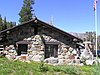 | December 14, 1978 (#78000372) | Southwest of Lee Vining 37°54′39″N 119°15′27″W / 37.910833°N 119.2575°W / 37.910833; -119.2575 (Tioga Pass Entrance Station) | Yosemite National Park | |
| 35 | Tuolumne Meadows | Upload image | November 30, 1978 (#78000371) | Southwest of Lee Vining 37°52′17″N 119°22′20″W / 37.871389°N 119.372222°W / 37.871389; -119.372222 (Tuolumne Meadows) | Yosemite National Park | Listing is for CCC camp structures in the meadow area |
| 36 | Tuolumne Meadows High Sierra Camp | 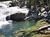 | July 18, 2014 (#14000419) | Along north bank of Dana Fork of Tuolumne River, east of Tuolumne Meadows 37°52′39″N 119°19′58″W / 37.877426°N 119.332655°W / 37.877426; -119.332655 (Tuolumne Meadows High Sierra Camp) | Yosemite National Park | |
| 37 | Tuolumne Meadows Ranger Stations and Comfort Stations |  | December 18, 1978 (#78000370) | Tuolumne Meadows 37°52′24″N 119°21′16″W / 37.873333°N 119.354444°W / 37.873333; -119.354444 (Tuolumne Meadows Ranger Stations and Comfort Stations) | Yosemite National Park | |
| 38 | Vogelsang High Sierra Camp |  | July 18, 2014 (#14000413) | Along Fletcher Creek, immediately southwest of Fletcher Lake 37°47′43″N 119°20′44″W / 37.795205°N 119.345431°W / 37.795205; -119.345431 (Vogelsang High Sierra Camp) | Yosemite National Park | |
| 39 | Wawona Covered Bridge |  | January 11, 2007 (#06001261) | Pioneer Yosemite History Center 37°32′19″N 119°39′17″W / 37.538611°N 119.654722°W / 37.538611; -119.654722 (Wawona Covered Bridge) | Wawona | |
| 40 | Wawona Hotel and Pavilion |  | October 1, 1975 (#75000223) | On CA 41 in Yosemite National Park 37°32′11″N 119°39′13″W / 37.536389°N 119.653611°W / 37.536389; -119.653611 (Wawona Hotel and Pavilion) | Wawona | |
| 41 | Yosemite Transportation Company Office |  | June 9, 1978 (#78000355) | Pioneer Yosemite History Center 37°32′20″N 119°39′17″W / 37.538889°N 119.654722°W / 37.538889; -119.654722 (Yosemite Transportation Company Office) | Wawona | |
| 42 | Yosemite Valley |  | December 14, 2006 (#04001159) | Yosemite National Park 37°43′43″N 119°36′07″W / 37.728611°N 119.601944°W / 37.728611; -119.601944 (Yosemite Valley) | Yosemite National Park | |
| 43 | Yosemite Valley Archeological District | Upload image | January 20, 1978 (#78000361) | Address Restricted | Yosemite National Park | |
| 44 | Yosemite Valley Bridges |  | November 25, 1977 (#77000160) | 8 bridges over Merced River, Yosemite Valley 37°43′58″N 119°36′00″W / 37.732778°N 119.6°W / 37.732778; -119.6 (Yosemite Valley Bridges) | Yosemite National Park | |
| 45 | Yosemite Valley Chapel |  | December 12, 1973 (#73000256) | Off CA 140 in Yosemite Valley 37°44′27″N 119°35′26″W / 37.740833°N 119.590556°W / 37.740833; -119.590556 (Yosemite Valley Chapel) | Yosemite National Park | |
| 46 | Yosemite Village Historic District | 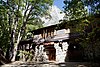 | March 30, 1978 (#78000354) | Yosemite Village 37°44′55″N 119°35′18″W / 37.748611°N 119.588333°W / 37.748611; -119.588333 (Yosemite Village Historic District) | Yosemite National Park |
Associated properties
The following properties are on property owned by the National Park Service and administered by Yosemite National Park, but are not within the park proper:
| [3] | Name on the Register[4] | Image | Date listed[5] | Location | City or town | Description |
|---|---|---|---|---|---|---|
| 1 | Bagby Stationhouse, Water Tanks and Turntable | 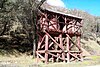 | April 13, 1979 (#79000316) | CA 140 37°40′27″N 119°46′47″W / 37.674167°N 119.779722°W / 37.674167; -119.779722 (Bagby Stationhouse, Water Tanks and Turntable) | El Portal | |
| 2 | Hetch Hetchy Railroad Engine No.6 |  | January 30, 1978 (#78000360) | CA 140 37°40′30″N 119°46′46″W / 37.675°N 119.779444°W / 37.675; -119.779444 (Hetch Hetchy Railroad Engine No.6) | El Portal | |
| 3 | Track Bus No. 19 |  | May 22, 1978 (#78000363) | CA 140 37°40′30″N 119°46′46″W / 37.675°N 119.779444°W / 37.675; -119.779444 (Track Bus No. 19) | El Portal | |
| 4 | Yosemite Valley Railroad Caboose No. 15 | 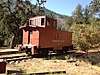 | May 22, 1978 (#78000352) | CA 140 37°40′30″N 119°46′46″W / 37.675°N 119.779444°W / 37.675; -119.779444 (Yosemite Valley Railroad Caboose No. 15) | El Portal |
See also
- National Register of Historic Places listings in Mariposa County, California
- National Register of Historic Places listings in Tuolumne County, California
- National Register of Historic Places listings in California
References
- ^ The latitude and longitude information provided in this table was derived originally from the National Register Information System, which has been found to be fairly accurate for about 99% of listings. Some locations in this table may have been corrected to current GPS standards.
- ^ National Park Service, United States Department of the Interior, "National Register of Historic Places: Weekly List Actions", retrieved September 13, 2024.
- ^ a b Numbers represent an alphabetical ordering by significant words. Various colorings, defined here, differentiate National Historic Landmarks and historic districts from other NRHP buildings, structures, sites or objects.
- ^ a b "National Register Information System". National Register of Historic Places. National Park Service. November 2, 2013.
- ^ a b The eight-digit number below each date is the number assigned to each location in the National Register Information System database, which can be viewed by clicking the number.
External links
Wikimedia Commons has media related to National Register of Historic Places in Yosemite National Park.
- v
- t
- e
Landmarks
historic districts
properties
- Acting Superintendent's Headquarters
- Buck Camp Patrol Cabin
- Camp 4
- Crane Flat Fire Lookout
- Degnan's Restaurant
- Frog Creek Cabin
- Glacier Point Trailside Museum
- Glen Aulin High Sierra Camp
- Great Sierra Wagon Road
- Half Dome Cables and Trail
- Hetch Hetchy Railroad Engine No.6
- Hodgdon Homestead Cabin
- Chris Jorgenson Studio
- Lake Vernon Snow Survey Shelter
- Mariposa Grove Museum
- May Lake High Sierra Camp
- McCauley Cabin
- McCauley and Meyer Barns
- McGurk Cabin
- Merced Grove Ranger Station
- Merced Lake High Sierra Camp
- Merced Lake Ranger Station
- Ostrander Lake Ski Hut
- Sachse Spring Snow Survey Shelter
- Snow Creek Ski Hut
- Snow Flat Snow Survey Shelter
- Soda Springs Cabin
- Sunrise High Sierra Camp
- Tioga Pass Entrance Station
- Track Bus No. 19
- Tuolumne Meadows
- Tuolumne Meadows High Sierra Camp
- Tuolumne Meadows Ranger Stations and Comfort Stations
- Vogelsang High Sierra Camp
- Wawona Covered Bridge
- Yosemite Transportation Company Office
- Yosemite Valley Chapel
- Yosemite Valley Railroad Caboose No. 15
| ||||||||
|---|---|---|---|---|---|---|---|---|
| Attractions |
| |||||||
| People | ||||||||
| Lodging and camping | ||||||||
| Natural disasters | ||||||||
| Transportation | ||||||||
| Nearby municipalities | ||||||||
| Additional information |
| |||||||

| |
|---|---|
| Topics | |
| Lists by state |
|
| Lists by insular areas | |
| Lists by associated state | |
| Other areas | |
| Related | |
| |


