National Register of Historic Places listings in Wayne County, Indiana
This is a list of the National Register of Historic Places listings in Wayne County, Indiana.
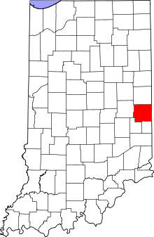
This is intended to be a complete list of the properties and districts on the National Register of Historic Places in Wayne County, Indiana, United States. Latitude and longitude coordinates are provided for many National Register properties and districts; these locations may be seen together in a map.[1]
There are 39 properties and districts listed on the National Register in the county, including 1 National Historic Landmark. Another 2 properties were once listed but have been removed.
Properties and districts located in incorporated areas display the name of the municipality, while properties and districts in unincorporated areas display the name of their civil township. Properties and districts split between multiple jurisdictions display the names of all jurisdictions.
This National Park Service list is complete through NPS recent listings posted June 21, 2024.[2]
Map all coordinates using OpenStreetMap
Download coordinates as:
- KML
- GPX (all coordinates)
- GPX (primary coordinates)
- GPX (secondary coordinates)
Current listings
| [3] | Name on the Register[4] | Image | Date listed[5] | Location | City or town | Description |
|---|---|---|---|---|---|---|
| 1 | Beechwood (Isaac Kinsey House) | 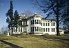 | February 21, 1975 (#75000031) | 2 miles south of Milton on Sarver Rd. 39°45′15″N 85°09′04″W / 39.754167°N 85.151111°W / 39.754167; -85.151111 (Beechwood (Isaac Kinsey House)) | Washington Township | |
| 2 | Bethel A.M.E. Church |  | September 5, 1975 (#75000032) | 200 S. 6th St. 39°49′33″N 84°53′41″W / 39.825833°N 84.894722°W / 39.825833; -84.894722 (Bethel A.M.E. Church) | Richmond | |
| 3 | Mary Birdsall House | 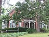 | September 23, 1999 (#99001155) | 504 NW. 5th St. 39°50′05″N 84°54′31″W / 39.834722°N 84.908611°W / 39.834722; -84.908611 (Mary Birdsall House) | Richmond | |
| 4 | Cambridge City Historic District | 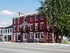 | June 14, 1991 (#91000787) | Roughly bounded by Boundary, Maple, High, and 4th Sts. 39°48′41″N 85°10′16″W / 39.811389°N 85.171111°W / 39.811389; -85.171111 (Cambridge City Historic District) | Cambridge City | |
| 5 | Centerville Historic District |  | October 26, 1971 (#71000008) | Bounded by the corporation limits, 3rd and South Sts., and Willow Grove Rd. 39°49′09″N 84°59′47″W / 39.819167°N 84.996389°W / 39.819167; -84.996389 (Centerville Historic District) | Centerville | |
| 6 | Levi Coffin House |  | October 15, 1966 (#66000009) | 115 N. Main St. 39°57′23″N 84°55′02″W / 39.956389°N 84.917222°W / 39.956389; -84.917222 (Levi Coffin House) | Fountain City | |
| 7 | Conklin-Montgomery House |  | February 24, 1975 (#75000033) | 302 E. Main St. 39°48′45″N 85°09′52″W / 39.8125°N 85.164444°W / 39.8125; -85.164444 (Conklin-Montgomery House) | Cambridge City | |
| 8 | David Worth Dennis House | 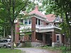 | April 25, 2001 (#01000404) | 610 W. Main St. 39°49′45″N 84°54′36″W / 39.829167°N 84.91°W / 39.829167; -84.91 (David Worth Dennis House) | Richmond | |
| 9 | Doddridge Chapel and Cemetery |  | September 28, 2003 (#03000984) | 9471 Chapel Rd., southwest of Centerville 39°45′04″N 85°03′21″W / 39.751111°N 85.055833°W / 39.751111; -85.055833 (Doddridge Chapel and Cemetery) | Washington Township | |
| 10 | Dublin Friends Meeting House | Upload image | September 4, 2018 (#100002868) | 2352 W. Maple St. 39°48′40″N 85°12′35″W / 39.811111°N 85.209722°W / 39.811111; -85.209722 (Dublin Friends Meeting House) | Dublin | |
| 11 | Earlham College Observatory |  | October 21, 1975 (#75000034) | National Rd. on the Earlham College campus 39°49′28″N 84°54′51″W / 39.824444°N 84.914167°W / 39.824444; -84.914167 (Earlham College Observatory) | Richmond | |
| 12 | East Main Street-Glen Miller Park Historic District |  | March 27, 1986 (#86000612) | Both sides of E. Main St. from N. 18th to N. 30th Sts. and Glen Miller Park east of 30th St. 39°49′58″N 84°52′04″W / 39.832778°N 84.867778°W / 39.832778; -84.867778 (East Main Street-Glen Miller Park Historic District) | Richmond | |
| 13 | Eliason Farm | Upload image | May 31, 2019 (#100004048) | 1594 N. Eliason Rd. 39°50′55″N 84°58′22″W / 39.8485°N 84.9729°W / 39.8485; -84.9729 (Eliason Farm) | Centerville vicinity | |
| 14 | Forest Hills Country Club |  | December 15, 2015 (#15000892) | 2169 S. 23rd St. 39°48′15″N 84°52′11″W / 39.804270°N 84.869644°W / 39.804270; -84.869644 (Forest Hills Country Club) | Wayne Township | |
| 15 | Fountain City Historic District | Upload image | September 4, 2018 (#100002869) | Roughly bounded by Noland's Fork and North, Hartley, and Vine Sts. 39°57′19″N 84°55′08″W / 39.9554°N 84.9189°W / 39.9554; -84.9189 (Fountain City Historic District) | Fountain City | |
| 16 | Abram Gaar House and Farm |  | February 20, 1975 (#75000035) | 2411 Pleasant View Rd., northeast of Richmond 39°50′57″N 84°52′00″W / 39.849167°N 84.866667°W / 39.849167; -84.866667 (Abram Gaar House and Farm) | Wayne Township | |
| 17 | Oliver P. and Mary Alice Gaar House |  | March 7, 2017 (#100000717) | 1307 E. Main St. 39°49′45″N 84°53′03″W / 39.829167°N 84.884167°W / 39.829167; -84.884167 (Oliver P. and Mary Alice Gaar House) | Richmond | |
| 18 | Henry and Alice Gennett House |  | August 11, 1983 (#83000043) | 1829 E. Main St. 39°49′47″N 84°52′37″W / 39.829722°N 84.876944°W / 39.829722; -84.876944 (Henry and Alice Gennett House) | Richmond | |
| 19 | Hagerstown I.O.O.F. Hall |  | January 3, 1978 (#78000041) | Main and Perry Sts. 39°54′40″N 85°09′37″W / 39.911111°N 85.160278°W / 39.911111; -85.160278 (Hagerstown I.O.O.F. Hall) | Hagerstown | |
| 20 | Hicksite Friends Meetinghouse (Wayne County Museum) |  | October 14, 1975 (#75000036) | 1150 N. A St. 39°49′51″N 84°53′13″W / 39.830833°N 84.886944°W / 39.830833; -84.886944 (Hicksite Friends Meetinghouse (Wayne County Museum)) | Richmond | |
| 21 | The Huddleston House Tavern |  | June 15, 1975 (#75000037) | E. U.S. Route 40 39°48′41″N 85°11′03″W / 39.811389°N 85.184167°W / 39.811389; -85.184167 (The Huddleston House Tavern) | Mount Auburn | |
| 22 | Lewis Jones House |  | June 7, 1984 (#84001744) | 5224 College Corner Rd., northeast of Centerville 39°49′52″N 84°58′33″W / 39.831111°N 84.975833°W / 39.831111; -84.975833 (Lewis Jones House) | Center Township | |
| 23 | King-Dennis Farm | 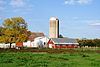 | June 15, 2000 (#00000677) | 2939 King Rd., north of Centerville 39°52′10″N 84°58′34″W / 39.869444°N 84.976111°W / 39.869444; -84.976111 (King-Dennis Farm) | Center Township | |
| 24 | Lackey-Overbeck House |  | May 28, 1976 (#76000030) | 520 E. Church St. 39°48′42″N 85°09′42″W / 39.811667°N 85.161667°W / 39.811667; -85.161667 (Lackey-Overbeck House) | Cambridge City | |
| 25 | Leland Hotel |  | February 28, 1985 (#85000362) | 900 S. A St. 39°49′39″N 84°53′24″W / 39.827500°N 84.890000°W / 39.827500; -84.890000 (Leland Hotel) | Richmond | |
| 26 | Oliver P. Morton House |  | October 10, 1975 (#75000038) | 319 W. Main St. 39°49′02″N 85°00′02″W / 39.817222°N 85.000556°W / 39.817222; -85.000556 (Oliver P. Morton House) | Centerville | |
| 27 | Murray Theater |  | March 25, 1982 (#82000053) | 1003 Main St. 39°49′44″N 84°53′19″W / 39.828889°N 84.888611°W / 39.828889; -84.888611 (Murray Theater) | Richmond | |
| 28 | Old Richmond Historic District |  | June 28, 1974 (#74000025) | Roughly bounded by the former C&O railroad line, S. 11th, S. A, and the alley south of South E St.; also roughly bounded by A, 11th, and E Sts., and the former C&O railroad tracks 39°49′21″N 84°53′32″W / 39.8225°N 84.892222°W / 39.8225; -84.892222 (Old Richmond Historic District) | Richmond | Second set of boundaries represents an increase and decrease of boundaries |
| 29 | Reeveston Place Historic District |  | January 17, 2003 (#02001171) | Bounded by S. B, S. E, S. 16th, and S. 23rd Sts. 39°49′26″N 84°52′32″W / 39.823828°N 84.875456°W / 39.823828; -84.875456 (Reeveston Place Historic District) | Richmond | |
| 30 | Richmond Downtown Historic District |  | December 19, 2011 (#11000918) | Roughly Main St. between 7th and 10th Sts. and N. 8th St. between Main and A Sts. 39°49′44″N 84°53′30″W / 39.828889°N 84.891667°W / 39.828889; -84.891667 (Richmond Downtown Historic District) | Richmond | |
| 31 | Richmond High School |  | September 22, 2015 (#15000602) | 380 Hub Etchison Parkway 39°49′21″N 84°54′05″W / 39.822500°N 84.901389°W / 39.822500; -84.901389 (Richmond High School) | Richmond | |
| 32 | Richmond Railroad Station Historic District |  | October 8, 1987 (#87001808) | Roughly bounded by the Norfolk Southern railroad tracks, N. 10th St., Elm Pl., N. D St., and Ft. Wayne Ave. 39°50′03″N 84°53′26″W / 39.834167°N 84.890556°W / 39.834167; -84.890556 (Richmond Railroad Station Historic District) | Richmond | |
| 33 | Andrew F. Scott House |  | October 10, 1975 (#75000039) | 126 N. 10th St. 39°49′53″N 84°53′22″W / 39.831389°N 84.889444°W / 39.831389; -84.889444 (Andrew F. Scott House) | Richmond | |
| 34 | Samuel G. Smith Farm |  | January 14, 1983 (#83000044) | West of Richmond at 3431 Crowe Rd. 39°50′23″N 84°56′51″W / 39.839722°N 84.9475°W / 39.839722; -84.9475 (Samuel G. Smith Farm) | Center Township | |
| 35 | Starr Historic District |  | June 28, 1974 (#74000026) | Roughly bounded by N. 16th, E and A Sts., and the alley west of N. 10th St. 39°49′57″N 84°53′05″W / 39.8325°N 84.884722°W / 39.8325; -84.884722 (Starr Historic District) | Richmond | |
| 36 | John & Caroline Stonebraker House |  | December 16, 2014 (#14001040) | 100 S. Washington St. 39°54′35″N 85°09′45″W / 39.909861°N 85.162500°W / 39.909861; -85.162500 (John & Caroline Stonebraker House) | Hagerstown | |
| 37 | Wayne County Courthouse |  | December 8, 1978 (#78000042) | Bounded by 3rd, 4th, Main, and S. A Sts. 39°49′42″N 84°53′50″W / 39.828333°N 84.897222°W / 39.828333; -84.897222 (Wayne County Courthouse) | Richmond | |
| 38 | Westcott Stock Farm |  | December 17, 1998 (#98001522) | 306 E. North St. 39°49′18″N 84°59′37″W / 39.821667°N 84.993611°W / 39.821667; -84.993611 (Westcott Stock Farm) | Centerville | |
| 39 | Witt-Champe-Myers House |  | June 9, 1995 (#95000700) | Southeastern corner of the junction of Spring and Foundry Sts. 39°48′38″N 85°12′07″W / 39.810556°N 85.201944°W / 39.810556; -85.201944 (Witt-Champe-Myers House) | Dublin |
Former listings
| [3] | Name on the Register | Image | Date listed | Date removed | Location | City or town | Description |
|---|---|---|---|---|---|---|---|
| 1 | Richmond Gas Company Building |  | August 25, 1981 (#81000023) | June 15, 2012 | 100 E. Main St. 39°49′47″N 84°53′58″W / 39.829722°N 84.899444°W / 39.829722; -84.899444 (Richmond Gas Company Building) | Richmond | |
| 2 | Starr Piano Company Warehouse and Administration Building |  | June 18, 1981 (#81000024) | May 1, 1995 | 300 S. 1st St. 39°49′29″N 84°54′00″W / 39.8247°N 84.9°W / 39.8247; -84.9 (Starr Piano Company Warehouse and Administration Building) | Richmond |
See also
Wikimedia Commons has media related to National Register of Historic Places in Wayne County, Indiana.
- List of National Historic Landmarks in Indiana
- National Register of Historic Places listings in Indiana
- Listings in neighboring counties: Darke (OH), Fayette, Henry, Preble (OH), Randolph, Union
- List of Indiana state historical markers in Wayne County
References
- ^ The latitude and longitude information provided in this table was derived originally from the National Register Information System, which has been found to be fairly accurate for about 99% of listings. Some locations in this table may have been corrected to current GPS standards.
- ^ National Park Service, United States Department of the Interior, "National Register of Historic Places: Weekly List Actions", retrieved June 21, 2024.
- ^ a b Numbers represent an alphabetical ordering by significant words. Various colorings, defined here, differentiate National Historic Landmarks and historic districts from other NRHP buildings, structures, sites or objects.
- ^ "National Register Information System". National Register of Historic Places. National Park Service. March 13, 2009.
- ^ The eight-digit number below each date is the number assigned to each location in the National Register Information System database, which can be viewed by clicking the number.
- v
- t
- e
- List of U.S. National Historic Landmarks by state:
- Alabama
- Alaska
- Arizona
- Arkansas
- California
- Colorado
- Connecticut
- Delaware
- Florida
- Georgia
- Hawaii
- Idaho
- Illinois
- Indiana
- Iowa
- Kansas
- Kentucky
- Louisiana
- Maine
- Maryland
- Massachusetts
- Michigan
- Minnesota
- Mississippi
- Missouri
- Montana
- Nebraska
- Nevada
- New Hampshire
- New Jersey
- New Mexico
- New York
- North Carolina
- North Dakota
- Ohio
- Oklahoma
- Oregon
- Pennsylvania
- Rhode Island
- South Carolina
- South Dakota
- Tennessee
- Texas
- Utah
- Vermont
- Virginia
- Washington
- West Virginia
- Wisconsin
- Wyoming
 National Register of Historic Places portal
 Category


