National Register of Historic Places listings in Columbia County, Washington

This list presents the full set of buildings, structures, objects, sites, or districts designated on the National Register of Historic Places in Columbia County, Washington, and offers brief descriptive information about each of them. The National Register recognizes places of national, state, or local historic significance across the United States.[1] Out of over 90,000 National Register sites nationwide,[2] Washington is home to approximately 1,500,[3] and 20 of those are found partially or wholly in Columbia County.
This National Park Service list is complete through NPS recent listings posted August 16, 2024.[4]
Current listings
| [5] | Name on the Register[6] | Image | Date listed[7] | Location | City or town | Description |
|---|---|---|---|---|---|---|
| 1 | Bank of Starbuck | 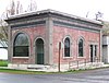 | February 8, 1978 (#78002739) | Main and McNeil Sts. 46°31′11″N 118°07′35″W / 46.519722°N 118.126389°W / 46.519722; -118.126389 (Bank of Starbuck) | Starbuck | |
| 2 | A. H. Bishop House |  | August 13, 1986 (#86001516) | 622 E. Richmond 46°19′33″N 117°58′31″W / 46.325833°N 117.975278°W / 46.325833; -117.975278 (A. H. Bishop House) | Dayton | |
| 3 | John Brining House |  | August 13, 1986 (#86001517) | 410 N. First 46°19′23″N 117°58′54″W / 46.323056°N 117.981667°W / 46.323056; -117.981667 (John Brining House) | Dayton | |
| 4 | Columbia County Courthouse | 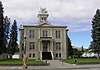 | February 10, 1975 (#75001845) | 341 E. Main 46°19′17″N 117°58′40″W / 46.321389°N 117.977778°W / 46.321389; -117.977778 (Columbia County Courthouse) | Dayton | |
| 5 | Dexter House No. 1 |  | August 13, 1986 (#86001519) | 515 S. Fourth 46°19′06″N 117°58′18″W / 46.318333°N 117.971667°W / 46.318333; -117.971667 (Dexter House No. 1) | Dayton | |
| 6 | Dexter House No. 2 |  | August 13, 1986 (#86001520) | 507 N. Third 46°19′28″N 117°58′47″W / 46.324444°N 117.979722°W / 46.324444; -117.979722 (Dexter House No. 2) | Dayton | |
| 7 | Downtown Dayton Historic District |  | May 31, 1999 (#99000567) | Roughly along Main St., from Front to third Sts. 46°19′15″N 117°58′41″W / 46.320833°N 117.978056°W / 46.320833; -117.978056 (Downtown Dayton Historic District) | Dayton | |
| 8 | Frank Flintner House |  | August 13, 1986 (#86001522) | 214 S. Sixth 46°19′15″N 117°58′18″W / 46.320833°N 117.971667°W / 46.320833; -117.971667 (Frank Flintner House) | Dayton | |
| 9 | Guernsey-Sturdevant Building |  | January 12, 1993 (#92001589) | 225 E. Main St. 46°19′12″N 117°58′45″W / 46.32°N 117.979167°W / 46.32; -117.979167 (Guernsey-Sturdevant Building) | Dayton | |
| 10 | Grover J. Israel House |  | August 13, 1986 (#86001525) | 305 S. Sixth 46°19′16″N 117°58′17″W / 46.321111°N 117.971389°W / 46.321111; -117.971389 (Grover J. Israel House) | Dayton | |
| 11 | Mancel Kelley House |  | August 13, 1986 (#86001526) | 1301 S. Fifth 46°18′37″N 117°57′41″W / 46.310278°N 117.961389°W / 46.310278; -117.961389 (Mancel Kelley House) | Dayton | |
| 12 | Mill House |  | August 13, 1986 (#86001528) | 504 N. First 46°19′25″N 117°58′57″W / 46.323611°N 117.9825°W / 46.323611; -117.9825 (Mill House) | Dayton | |
| 13 | Andrew Nilsson House |  | August 13, 1986 (#86001530) | 312 E. Patit 46°19′23″N 117°58′45″W / 46.323056°N 117.979167°W / 46.323056; -117.979167 (Andrew Nilsson House) | Dayton | |
| 14 | Oregon Railway and Navigation Company Depot – Dayton |  | November 19, 1974 (#74001949) | 222 E. Commercial St. 46°19′15″N 117°58′44″W / 46.320833°N 117.978889°W / 46.320833; -117.978889 (Oregon Railway and Navigation Company Depot – Dayton) | Dayton | Originally listed on the National Register as "Dayton Depot". The listing name was changed when the National Park Service accepted updated documentation for the depot in 2017.[8] |
| 15 | Dr. Marcel Pietrzycki House |  | August 13, 1986 (#86001531) | 415 E. Clay 46°19′16″N 117°58′31″W / 46.321111°N 117.975278°W / 46.321111; -117.975278 (Dr. Marcel Pietrzycki House) | Dayton | |
| 16 | Snake River Bridge |  | July 16, 1982 (#82004207) | N of SR 12 46°35′28″N 118°13′28″W / 46.591111°N 118.224444°W / 46.591111; -118.224444 (Snake River Bridge) | Lyons Ferry | Historic Bridges and Tunnels in Washington TR |
| 17 | South Side Historic District | 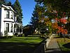 | August 13, 1986 (#86001515) | Roughly bounded by Clay, Third, Park, and First Sts. 46°19′04″N 117°58′33″W / 46.317778°N 117.975833°W / 46.317778; -117.975833 (South Side Historic District) | Dayton | |
| 18 | J. A. Thronson House |  | August 13, 1986 (#86001532) | 510 S. Fourth 46°19′05″N 117°58′19″W / 46.318056°N 117.971944°W / 46.318056; -117.971944 (J. A. Thronson House) | Dayton | |
| 19 | Washington Street Historic District | 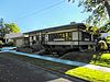 | August 13, 1986 (#86001514) | Roughly Washington St. between Patit Creek and Third St. 46°19′19″N 117°58′49″W / 46.321944°N 117.980278°W / 46.321944; -117.980278 (Washington Street Historic District) | Dayton | |
| 20 | Jacob Weinhard House |  | August 13, 1986 (#86001524) | NW of Dayton 46°19′17″N 117°59′47″W / 46.321389°N 117.996389°W / 46.321389; -117.996389 (Jacob Weinhard House) | Dayton |
See also
- National Register of Historic Places listings in Washington state
- Listings in neighboring counties: Franklin, Garfield, Umatilla, Walla Walla, Wallowa, Whitman
- Historic preservation
- History of Washington (state)
- Index of Washington (state)-related articles
References
- ^ Andrus, Patrick W.; Shrimpton, Rebecca H.; et al. (2002). "How to Apply the National Register Criteria for Evaluation". National Register Bulletin. National Park Service, U.S. Department of the Interior. Retrieved June 20, 2014.
- ^ National Park Service. "National Register of Historic Places Program: Research". Retrieved January 28, 2015.
- ^ Department of Archaeology and Historic Preservation. "Washington Information System for Architectural and Archaeological Records Data (WISAARD)". Retrieved February 14, 2015.
- ^ National Park Service, United States Department of the Interior, "National Register of Historic Places: Weekly List Actions", retrieved August 16, 2024.
- ^ Numbers represent an alphabetical ordering by significant words. Various colorings, defined here, differentiate National Historic Landmarks and historic districts from other NRHP buildings, structures, sites or objects.
- ^ "National Register Information System". National Register of Historic Places. National Park Service. April 24, 2008.
- ^ The eight-digit number below each date is the number assigned to each location in the National Register Information System database, which can be viewed by clicking the number.
- ^ National Park Service (May 12, 2017), Weekly List of Actions Taken on Properties: 5/01/17 through 5/5/17, archived from the original on May 21, 2017, retrieved May 21, 2017.
External links
Map all coordinates using OpenStreetMap
Download coordinates as:
- KML
- GPX (all coordinates)
- GPX (primary coordinates)
- GPX (secondary coordinates)
- Washington Department of Archaeology and Historic Preservation, Historic Register program
- National Park Service, National Register of Historic Places site
 Media related to National Register of Historic Places in Columbia County, Washington at Wikimedia Commons
- v
- t
- e
National Register of Historic Places listings in Washington (state)
by county
- Adams
- Asotin
- Benton
- Chelan
- Clallam
- Clark
- Columbia
- Cowlitz
- Douglas
- Ferry
- Franklin
- Garfield
- Grant
- Grays Harbor
- Island
- Jefferson
- King
- Kitsap
- Kittitas
- Lewis
- Lincoln
- Mason
- Okanogan
- Pacific
- Pend Oreille
- Pierce
- San Juan
- Skagit
- Skamania
- Snohomish
- Spokane
- Stevens
- Thurston
- Wahkiakum
- Walla Walla
- Whatcom
- Whitman
- Yakima

- National Historic Landmarks
- Bridges and Tunnels
| |
|---|---|
| Topics | |
| Lists by state |
|
| Lists by insular areas | |
| Lists by associated state | |
| Other areas | |
| Related | |
| |


Municipalities and communities of Columbia County, Washington, United States | ||
|---|---|---|
County seat: Dayton | ||
| City |  | |
| Town | ||
| Unicorporated communities | ||
| Ghost towns | ||
| ||


