Marsh Creek Lake
Reservoir in Chester County, Pennsylvania
40°04′N 75°44′W / 40.07°N 75.73°W / 40.07; -75.73Marsh Creek Lake is a man-made lake that resulted from the construction of a dam across Marsh Creek, filling a valley that prompted the relocation of residents from Milford Mills, Pennsylvania to higher ground. The reasons for creating the lake were "... frequent flooding, water shortages and lack of recreational opportunities for nearby population centers...."[1]
The lake is bordered by Marsh Creek State Park to the east and Lyndell, Pennsylvania to the west.
Gallery
-
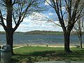 Marsh Creek facing west
 -
 Marsh Creek facing north
 -
 Marsh Creek facing east


References
- ^ "Marsh Creek State Park". Archived from the original on October 10, 2011.
- v
- t
- e
Municipalities and communities of Chester County, Pennsylvania, United States
County seat: West Chester
- Coatesville

- Atglen
- Avondale
- Downingtown
- Elverson
- Honey Brook
- Kennett Square
- Malvern
- Modena
- Oxford
- Parkesburg
- Phoenixville
- South Coatesville
- Spring City
- West Chester
- West Grove
- Birmingham
- Caln
- Charlestown
- East Bradford
- East Brandywine
- East Caln
- East Coventry
- East Fallowfield
- East Goshen
- East Marlborough
- East Nantmeal
- East Nottingham
- East Pikeland
- East Vincent
- East Whiteland
- Easttown
- Elk
- Franklin
- Highland
- Honey Brook
- Kennett
- London Britain
- London Grove
- Londonderry
- Lower Oxford
- New Garden
- New London
- Newlin
- North Coventry
- Penn
- Pennsbury
- Pocopson
- Sadsbury
- Schuylkill
- South Coventry
- Thornbury
- Tredyffrin
- Upper Oxford
- Upper Uwchlan
- Uwchlan
- Valley
- Wallace
- Warwick
- West Bradford
- West Brandywine
- West Caln
- West Fallowfield
- West Goshen
- West Marlborough
- West Nantmeal
- West Nottingham
- West Pikeland
- West Sadsbury
- West Vincent
- West Whiteland
- Morstein
- Westtown
- Willistown
- Berwyn
- Caln
- Cambridge‡
- Chadds Ford‡
- Chesterbrook
- Cheyney University‡
- Cochranville
- Devon
- Dilworthtown‡
- Eagle
- Eagleview
- Exton
- Frazer
- Glenmoore
- Hamorton
- Hayti
- Kenilworth
- Kimberton
- Lincoln University
- Lionville
- Marshallton
- Nottingham
- Paoli
- Pomeroy
- Pughtown
- Sadsburyville
- South Pottstown
- Thorndale
- Toughkenamon
- Unionville
- Westwood
communities
- Birchrunville
- Black Horse
- Brandamore
- Bucktown
- Byers Station
- Cedarville
- Chatham
- Chester Springs
- Chesterville
- Compass
- Coventryville
- Cromby
- Darlington Corners
- Daylesford
- Devault
- Doe Run
- Dorlan
- Embreeville
- Ercildoun
- Faggs Manor
- Glenloch
- Goshenville
- Hallman
- Harmonyville
- Hayesville
- Hephzibah
- Hickory Hill
- Hiestand
- Hinsonville
- Homeville
- Hopewell†
- Howellville
- Humphreyville
- Icedale
- Ironsides
- Isabella
- Jennersville
- Kaolin
- Kelton
- Kemblesville
- Knauertown
- Landenberg
- Lenape
- Lewisville
- London Grove
- Longwood Gardens
- Lower Hopewell
- Ludwigs Corner
- Lyndell
- Mendenhall
- Milford Mills
- Mortonville
- Nantmeal Village
- Parker Ford
- Pocopson
- Russellville
- St. Peters
- Siousca
- Springdell
- Steelville
- Strafford‡
- Strickersville
- Sugartown
- Suplee
- Valley Forge
- Wagontown
- Warwick
- Wayne‡
- West Goshen
- Whitford
- Willowdale
- Yellow Springs
‡This populated place also has portions in an adjacent county or counties †Former borough
- Pennsylvania portal
- United States portal
| Authority control databases |
|
|---|
 | This Chester County, Pennsylvania state location article is a stub. You can help Wikipedia by expanding it. |
- v
- t
- e


