List of covered bridges in Kentucky

Below is a list of covered bridges in Kentucky. There are eleven surviving authentic covered bridges in the U.S. state of Kentucky, and they are all historic.[1] A covered bridge is considered authentic not due to its age, but by its construction. An authentic bridge is constructed using trusses rather than other methods such as stringers, a popular choice for non-authentic covered bridges. There once were hundreds of these in Kentucky.
Bridges
Extant
| Name | Image | County | Location | Built | Length | Crosses | Ownership | Truss | Notes |
|---|---|---|---|---|---|---|---|---|---|
| Bennett's Mill Covered Bridge[2] | 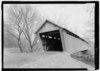 | Greenup | Greenup 38°37′50″N 82°55′37″W / 38.63056°N 82.92694°W / 38.63056; -82.92694 (Bennett's Mill Covered Bridge) | ca. 1855, 2004 | 145 feet (44 m) | Tygarts Creek | County of Greenup | Modified Wheeler or Warren | |
| Cabin Creek Covered Bridge[2] |  | Lewis | Tollesboro 38°37′13″N 83°37′16″W / 38.62028°N 83.62111°W / 38.62028; -83.62111 (Cabin Creek Covered Bridge) | ca. 1867 | 114 feet (35 m) | Cabin Creek | State of Kentucky | Multiple king | Also called C.F. Ferguson Farm, Mackey, or Hughes Farm Covered Bridge[3] |
| Colville Covered Bridge[2] | 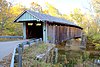 | Bourbon | Millersburg 38°19′29″N 84°12′12″W / 38.32472°N 84.20333°W / 38.32472; -84.20333 (Colville Covered Bridge) | 1877, 2002 | 120 feet (37 m) | Hinkston Creek | County of Bourbon | Multiple king | |
| Goddard Bridge[2] |  | Fleming | Goddard 38°21′44″N 83°36′56″W / 38.36222°N 83.61556°W / 38.36222; -83.61556 (Goddard Bridge) | 1864, 1933 | 60 feet (18 m) | Sand Lick Creek | County of Fleming | Town | Also called White Bridge[3] |
| Hillsboro Covered Bridge[2] |  | Fleming | Hillsboro 38°15′17″N 83°39′11″W / 38.25472°N 83.65306°W / 38.25472; -83.65306 (Hillsboro Covered Bridge) | ca. 1865 | 80 feet (24 m) | Fox Creek | County of Fleming | Multiple king | Also called Grange City Covered Bridge[3] |
| Johnson Creek Covered Bridge[2] |  | Robertson | Mount Olivet 38°28′52″N 83°58′37″W / 38.48111°N 83.97694°W / 38.48111; -83.97694 (Johnson Creek Covered Bridge) | 1874 | 110 feet (34 m) | Blue Lick Springs | County of Robertson | Smith | |
| Lee's Creek Covered Bridge[2] |  | Mason | Dover 38°44′59″N 83°52′44″W / 38.74972°N 83.87889°W / 38.74972; -83.87889 (Lee's Creek Covered Bridge) | 1835 | 60 feet (18 m) | Lee's Creek | County of Mason | Queen | Also called Dover Covered Bridge[3] |
| Oldtown Covered Bridge[2] |  | Greenup | Oldtown 38°25′53″N 82°53′42″W / 38.43139°N 82.89500°W / 38.43139; -82.89500 (Oldtown Covered Bridge) | 1850-1874, 1999 | 190 feet (58 m) | Frazer Branch, Little Sandy Creek | County of Greenup | Warren or Multiple king | |
| Ringos Mill Covered Bridge[2] | 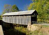 | Fleming | Flemingsburg 38°16′6″N 83°36′38″W / 38.26833°N 83.61056°W / 38.26833; -83.61056 (Ringos Mill Covered Bridge) | 1867 | 86 feet (26 m) | Fox Creek | County of Fleming | Multiple king | |
| Switzer Covered Bridge[2] |  | Franklin | Switzer 38°15′14″N 84°45′8″W / 38.25389°N 84.75222°W / 38.25389; -84.75222 (Switzer Covered Bridge) | 1855, 1998 | 120 feet (37 m) | North Fork, Elkhorn Creek | County of Franklin | Howe | |
| Walcott Covered Bridge[2] |  | Bracken | Brooksville 38°44′0″N 84°6′2″W / 38.73333°N 84.10056°W / 38.73333; -84.10056 (Walcott Covered Bridge) | ca. 1880, 2001 | 76 feet (23 m) | Locust Creek | Private | Queen and multiple king |
Former
This transport-related list is incomplete; you can help by adding missing items. (October 2021) |
| Name | Image | County | Location | Built | Length | Crosses | Ownership | Truss | Notes |
|---|---|---|---|---|---|---|---|---|---|
| Mount Zion Covered Bridge[2] |  | Washington | Mooresville 37°49′40″N 85°15′23″W / 37.82778°N 85.25639°W / 37.82778; -85.25639 (Mount Zion Covered Bridge) | 1871–2021 | 258 feet (79 m) | Beech Fork | Kentucky Department of Highways | Burr | Also called Beech Fork Covered Bridge.[3] Lost to arson on March 9, 2021.[4] |
| Valley Pike Covered Bridge[3] |  | Mason | Fernleaf 38°40′27″N 83°52′20″W / 38.67417°N 83.87222°W / 38.67417; -83.87222 (Valley Pike Covered Bridge) | 1864 | 35 feet (11 m) | Lee's Creek | Private | King | Also called Bouldin or Daugherty Covered Bridge. Dismantled on April 27, 2018.[4] |
See also
 Engineering portal
 Transportation portal
 Kentucky portal


- List of bridges on the National Register of Historic Places in Kentucky
- World Guide to Covered Bridges
References
Map all coordinates using OpenStreetMap
Download coordinates as:
- KML
- GPX (all coordinates)
- GPX (primary coordinates)
- GPX (secondary coordinates)
- ^ "12 Historic Covered Bridges in Kentucky". Only in Your State. Leaf Group Lifestyle. Retrieved 17 May 2020.
- ^ a b c d e f g h i j k l "National Register Information System". National Register of Historic Places. National Park Service. July 9, 2010.
- ^ a b c d e f Wright, David W. (2009). World Guide to Covered Bridges (2009 ed.). Concord, New Hampshire: National Society for Preservation of Covered Bridges. pp. 33–36. ISBN 978-0-692-00617-7.
- ^ a b Caswell, William S. World Guide to Covered Bridges (2021 ed.). Concord, New Hampshire: National Society for the Preservation of Covered Bridges. p. xxxii. ISBN 978-0-578-30263-8.
Further reading
Robert W. M. Laughlin; Melissa C. Jurgensen (2007). Kentucky's Covered Bridges. Charleston, South Carolina: Arcadia Publishing. ISBN 978-0-738-54404-5.
External links
Wikimedia Commons has media related to Covered bridges in Kentucky.
- National Society for the Preservation of Covered Bridges
- Lexington Visitors Center article about the state's covered bridges
- v
- t
- e
- Alabama
- Alaska
- Arizona
- Arkansas
- California
- Colorado
- Connecticut
- Delaware
- Florida
- Georgia
- Hawaii
- Idaho
- Illinois
- Indiana
- Iowa
- Kansas
- Kentucky
- Louisiana
- Maine
- Maryland
- Massachusetts
- Michigan
- Minnesota
- Mississippi
- Missouri
- Montana
- Nebraska
- Nevada
- New Hampshire
- New Jersey
- New Mexico
- New York
- North Carolina
- North Dakota
- Ohio
- Oklahoma
- Oregon
- Pennsylvania
- Rhode Island
- South Carolina
- South Dakota
- Tennessee
- Texas
- Utah
- Vermont
- Virginia
- Washington
- West Virginia
- Wisconsin
- Wyoming


