Holzbrücke Bad Säckingen
Bridge
47°33′05″N 7°57′06″E / 47.551367°N 7.951685°E / 47.551367; 7.951685
Holzbrücke Bad Säckingen (German name) or Säckingerbrücke (Swiss name) is a bridge over the Rhine. It connects the German city of Bad Säckingen with the village Stein in Switzerland. The covered bridge spans 203.7 metres (668 ft) over the Hochrhein and is the longest roofed wooden bridge in Europe. The bridge is listed as a national registered monument in Switzerland (Kulturgut von nationaler Bedeutung im Kanton Aargau).
The bridge was built in 1272 and was destroyed several times (1570, 1633, 1678). The current bridge was completed in 1700. Originally a road bridge, the bridge is now only open for pedestrians since the Fridolinsbrücke (Swiss name: Rheinbrücke Stein) was opened in 1979 for road traffic.
-
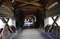 inside
 -
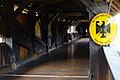
 Entrance in Switzerland
 -
 Entrance in Switzerland
 -
 The boundary line in the middle of the Rhine


See also
- List of bridges over the Rhine
- List of bridges in Germany
- List of bridges in Switzerland
- Other big wooden bridges in Switzerland
- Kapellbrücke
- Auguetbrücke
References
External links
 Media related to Holzbrücke Bad Säckingen at Wikimedia Commons
| Authority control databases: Geographic |
|
|---|
47°33′05″N 7°57′05″E / 47.55139°N 7.95139°E / 47.55139; 7.95139
- v
- t
- e
 | This article about a Swiss building or structure is a stub. You can help Wikipedia by expanding it. |
- v
- t
- e
  | This article about a bridge in Germany is a stub. You can help Wikipedia by expanding it. |
- v
- t
- e


