Hobart Rivulet
River in Tasmania, Australia
42°54′26″S 147°14′49″E / 42.90722°S 147.24694°E / -42.90722; 147.24694
• location
• coordinates
• elevation
The Hobart Rivulet, part of the River Derwent catchment, is an urban stream located in the Hobart hinterland and flows through and underneath the city, in Tasmania, Australia.
Course and features
The rivulet rises on the slopes of Mount Wellington and flows generally northeast over O'Grady's Falls, Strickland Falls, through South Hobart and past what was known as the World Heritage-listed Cascades Female Factory towards the Hobart central business district. As a result of urban development, the natural course has been altered significantly. The lower portion of the rivulet has been piped through the city and runs below the central city area. The rivulet emerges again near the Royal Hobart Hospital on Collins Street before flowing underneath the Cenotaph and emptying into the Derwent.[2][3] The rivulet descends 544 metres (1,785 ft) over its 7.3-kilometre (4.5 mi) course.[1]
Regular tours of the rivulet once took place under the CBD.[4] The sandstone Wellington Bridge (1841) over the rivulet lies under the Elizabeth Street Mall, and is visible through a viewing portal there.[5][2][6]
-
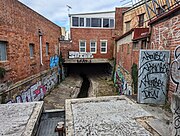
 Underneath Hobart
 -
 At Barrack Street
 -
 At Collins Street
 -
 At Collins Street
 -
 At Harrington Street
 -
 At Molle Street
 -
 At Molle Street


History
The rivulet was an important source of drinking water for the Mouheneener Aborigines, and later for the first European settlers.[7] The site for Hobart was originally chosen in part due to the availability of fresh water from the rivulet.[7] Because of the pure water of the upper portion of the rivulet, the Cascade Brewery was built beside it.[8] There were several typhoid epidemics during the late 19th century due to poor water quality further downstream.[7] It was also an important source of energy for early industry in Hobart.[7] There are multiple old bridges over the Hobart Rivulet. The oldest is the Wellington Bridge that is on Elizabeth Street built in 1841. Second oldest is the Harrington Street Bridge built in 1844. Third oldest is the Molle Street Bridge built in 1866.
See also
 Australia portal
 Environment portal
 Water portal


References
- ^ a b "Map of Hobart Rivulet, TAS". Bonzle Digital Atlas of Australia. 2015. Retrieved 29 June 2016.
- ^ a b Raabus, Carol; Saunders, Louise (11 October 2013). "Time to reveal Hobart's hidden rivulet". Australia, Hobart: ABC News. Retrieved 29 June 2016.
- ^ "Hobart Rivulet". Visit. Tasmanian Government. February 2004.
- ^ AboutAustralia.com.au – Hobart Rivulet Tours
- ^ "Engineering Heritage Walk leaflet". Engineers Australia.
- ^ further item on ABC http://www.abc.net.au/news/2016-08-01/going-underground-in-the-hobart-rivulet/7676134?section=tas
- ^ a b c d The Companion to Tasmanian History – Hobart Rivulet
- ^ Vaisutis, Justine; Blond, Becca; Brown, Lindsay (2007). Australia. Lonely Planet. p. 620. ISBN 978-1-74104-310-5.
- v
- t
- e
 Hobart landmarks
- Cadbury's Chocolate Factory
- Calvary Hospital
- Cascade Brewery
- Canopus Hill Observatory
- Davey Street Congregational Church
- General Post Office
- Hobart Cenotaph
- Holy Trinity Church
- Hope and Anchor Tavern
- Hotel Grand Chancellor
- ICON Complex
- Iron Pot Lighthouse
- Incat
- Ingle Hall
- Kelly's Steps
- Hobart Mosque
- Mount Pleasant Radio Observatory
- NAB House
- Nyrstar Hobart
- The Old Woolstore Apartment Hotel
- Hobart Private Hospital
- Princes Wharf
- Queen Alexandra Hospital
- Railway Roundabout
- Royal Hobart Hospital
- Taroona Shot Tower
- St David's Cathedral
- St John's Anglican Church
- St Mary's Cathedral
- Hobart Synagogue
- Trafalgar Building
- Anglesea Barracks
- Australian Antarctic Division
- College of Arts, Law and Education
- Derwent Barracks
- Government House
- The Hedberg
- Institute for Marine and Antarctic Studies
- Menzies Institute for Medical Research
- Parliament House
- Parliament Square
- State Library
- Supreme Court
- Tasmanian Conservatorium of Music
- Town Hall
- Hobart Aquatic Centre
- Baskerville Raceway
- Bellerive Yacht Club
- Blundstone Arena
- Clarence Aquatic Centre
- Domain Athletic Centre
- Elwick Racecourse
- Glenorchy Ice Skating Rink
- Hobart International Tennis Centre
- KGV Oval
- KGV Park
- Kingborough Sports Centre
- North Hobart Oval
- Queenborough Oval
- Hobart Real Tennis Club
- Royal Yacht Club of Tasmania
- Tasmanian Hockey Centre
- TCA Ground
- Warrior Park
- Wentworth Park
- Hobart Airport
- Bowen Bridge
- Bridgewater Bridge
- Brooke Street Pier
- Hobart Bus Mall
- Cambridge Aerodrome
- Constitution Dock
- Jordan River Bridge
- McGees Bridge
- Sorell Causeway
- Tasman Bridge
- Victoria Dock
- Alum Cliffs
- Ancanthe Park
- Bonorong Wildlife Sanctuary
- East Risdon Nature Reserve
- Botanical Gardens
- Franklin Square
- Glenorchy Art and Sculpture Park
- Hobart Rivulet
- kunanyi / Mount Wellington
- Moorilla Estate
- Queens Domain
- St David's Park
- Zoodoo Wildlife Park
River systems and rivers of Tasmania, Australia | |||||
|---|---|---|---|---|---|
| |||||
| |||||
| |||||
|

This article about a river in Tasmania is a stub. You can help Wikipedia by expanding it. |
- v
- t
- e


