Grays River Covered Bridge
Historic covered bridge in Washington state
46°21′17.60″N 123°34′52.12″W / 46.3548889°N 123.5811444°W / 46.3548889; -123.5811444Grays River Covered Bridge

The Grays River Covered Bridge in 1988

The Grays River Covered Bridge is a one-lane covered bridge over the Grays River in western Wahkiakum County, Washington.[2] It is the only covered bridge still in use as a public highway in Washington State. The bridge was added to the National Register of Historic Places in 1971.[3]
History
The bridge was built in 1905 in order to allow horse and wagon agricultural traffic to cross the river. Hans P. Ahlberg, whose dairy farm spanned both sides of the river, was instrumental in getting county commissioners to authorize the project, which was built on his property by the Ferguson & Huston company of Astoria, Oregon.[4] The bridge was covered three years later in 1908 to preserve the expensive wooden trusses from the ravages of the area rains.[5] The roof of the covered bridge was originally built of "board and batten cedar siding with a capped tin roof."[4]
The bridge received a major restoration and reconstruction in 1988. In disrepair and at risk of being torn down, residents worked to raise funds for restoration. Reconstruction was completed by Dulin Construction of Centralia, Washington, for a cost of $295,980.00. The new bridge included steel beams some of which received a wood veneer to maintain the bridge's historic appearance.[4] On September 30, 1989, the bridge was rededicated to public use, with author, granger, and Grays River resident Robert Michael Pyle serving as master of ceremonies.[5]
Engineering
The Howe truss timber bridge with timber decking spans 155.5 feet (47.4 m), is 22.5 feet (6.9 m) high with 16.75 feet (5.11 m) inside clearance, and is 14 feet (4.3 m) wide. Cedar shingles cover the exterior.[4]
-
 1905 bridge plans drawn up by Ferguson & Houston of Astoria, Oregon
 -
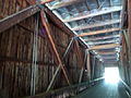 Inside the Grays River Covered Bridge showing the Howe truss


Management
The bridge is the centerpiece of Ahlberg Park, which has been managed by the Grays River Grange since 2011[6][7] and is the site of an annual Covered Bridge Festival.[8][9]
See also
- List of bridges documented by the Historic American Engineering Record in Washington (state)
References
- ^ "National Register Information System". National Register of Historic Places. National Park Service. January 23, 2007.
- ^ "Grays River Covered Bridge". Geographic Names Information System. United States Geological Survey, United States Department of the Interior.
- ^ "National Register of Historic Places Registration Form". National Park Service. November 23, 1971. Retrieved April 20, 2015.
- ^ a b c d Bruce, Robin (August 1991). "Grays River Covered Bridge" (PDF). Historic American Engineering Record. Washington, D.C.: Library of Congress. Retrieved April 7, 2011.
- ^ a b Oldham, Kit (December 29, 2006). "Rehabilitation of the Grays River Bridge". The Online Encyclopedia of Washington State History. HistoryLink. Retrieved June 30, 2013.
- ^ Ammer, Darlene (August 19, 2010). "Grange News". The Wahkiakum County Eagle. Retrieved June 11, 2015.
- ^ Ammer, Darlene (October 13, 2011). "Grange News". The Wahkiakum County Eagle. Retrieved June 11, 2015.
- ^ "Information: Grays River Covered Bridge". Wahkiakum County Chamber of Commerce. Retrieved June 11, 2015.
- ^ Richenda, P. "Virtual Valley Tour: Grays River Covered Bridge". GraysRiver.org. Grays River United Methodist Church. Retrieved June 11, 2015.
External links
Wikimedia Commons has media related to Grays River Covered Bridge.
- Historic American Engineering Record (HAER) No. WA-28, "Grays River Covered Bridge", 19 photos, 8 data pages by Robin Bruce, 1991
- Covered bridge over the Grays River, 1967 (Werner Leggenhager) University of Washington Digital Collection
- v
- t
- e
National Register of Historic Places listings in Washington (state)
by county
- Adams
- Asotin
- Benton
- Chelan
- Clallam
- Clark
- Columbia
- Cowlitz
- Douglas
- Ferry
- Franklin
- Garfield
- Grant
- Grays Harbor
- Island
- Jefferson
- King
- Kitsap
- Kittitas
- Lewis
- Lincoln
- Mason
- Okanogan
- Pacific
- Pend Oreille
- Pierce
- San Juan
- Skagit
- Skamania
- Snohomish
- Spokane
- Stevens
- Thurston
- Wahkiakum
- Walla Walla
- Whatcom
- Whitman
- Yakima

- National Historic Landmarks
- Bridges and Tunnels
| Authority control databases |
|
|---|


