Grade II listed buildings in the London Borough of Wandsworth
Map all coordinates using OpenStreetMap
Download coordinates as:
- KML
- GPX (all coordinates)
- GPX (primary coordinates)
- GPX (secondary coordinates)
This page is a list of classified buildings Grade IIs in the London Borough of Wandsworth.
| Name | Location | Type | Completed [note 1] | Date designated | Grid ref.[note 2] Geo-coordinates | Entry number [note 3] | Image |
|---|---|---|---|---|---|---|---|
| All Saints Church, Tooting | Brudenell Road, Tooting, Greater London, SW17 8DF | Parish church | 1903 and 1906 | 14 July 1955 | TQ2819071762 51°25′50″N 0°09′26″W / 51.43047°N 0.15733°W / 51.43047; -0.15733 (All Saints Church, Tooting) | 1357655 |  More images |
| Arding & Hobbs | Lavender Hill and St John's Road, Battersea, London SW11 1QL | Shop | 1910 | 30 November 2001 | TQ2740575426 51°27′49″N 0°10′03″W / 51.463475°N 0.167371°W / 51.463475; -0.167371 (Arding & Hobbs) | 1389528 |  More images |
| Ark John Archer Primary Academy | Plough Road, Battersea, London, SW11 2AA | School | Early 19th century | 7 April 1983 | TQ2689875236 51°27′43″N 0°10′29″W / 51.461882°N 0.174733°W / 51.461882; -0.174733 (Ark John Archer Primary Academy) | 1065515 | 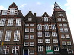 More images |
| Battersea Bridge | BATTERSEA BRIDGE, BATTERSEA BRIDGE SW 11 | Bridge | 21 July 1890 | 7 April 1983 | TQ2688777432 51°28′52″N 0°10′21″W / 51.481111°N 0.1725°W / 51.481111; -0.1725 (Battersea Bridge) | 1080752 |  More images |
| Battersea Reference Library | Altenburg Gardens, Battersea, London, SW11 1JB | Library | 1924 | 7 April 1983 | TQ2754275525 51°27′50″N 0°09′50″W / 51.46382°N 0.16375°W / 51.46382; -0.16375 (Battersea Reference Library) | 1200731 |  More images |
| Battersea Park railway station | Battersea Park Road, SW8 | Railway station | 1 May 1867 | TQ2861877118 51°28′40″N 0°08′52″W / 51.4779°N 0.1477°W / 51.4779; -0.1477 (Battersea Park railway station) | 1357652 |  More images | |
| The Bedford Hotel | 77 Bedford Hill, Balham, London SW12 9HD | Public house | 1931 | 24 August 2015 | TQ2872073144 51°26′34″N 0°08′57″W / 51.442670°N 0.149281°W / 51.442670; -0.149281 (The Bedford Hotel) | 1427422 |  More images |
| Brandlehow School | Brandlehow Road, Putney, London SW15 | School | 1950 | 30 March 1993 | TQ2466975124 51°27′41″N 0°12′25″W / 51.46137°N 0.206841°W / 51.46137; -0.206841 (Brandlehow School) | 1126541 |  More images |
| Chelsea Bridge | Battersea and Chelsea | Bridge | 6 May 1937 | 26 November 2008 | TQ2856377802 51°29′05″N 0°09′00″W / 51.484722°N 0.15°W / 51.484722; -0.15 (Chelsea Bridge) | 1393009 |  More images |
| Drinking Fountain, Roehampton public house | Roehampton Lane, Roehampton, London SW15 | Fountain | 1882 | 7 April 1983 | TQ2241473767 51°26′59″N 0°14′23″W / 51.449666°N 0.239754°W / 51.449666; -0.239754 (Drinking Fountain, Roehampton public house) | 1065484 |  More images |
| The Duke's Head, Putney | 8 Lower Richmond Road, Putney, London | Public house | 21 October 2005 | TQ2393875765 51°28′02″N 0°13′02″W / 51.467291°N 0.217134°W / 51.467291; -0.217134 (The Duke's Head, Putney) | 1391758 |  More images | |
| Fairacres, Roehampton | 1–64, Roehampton Lane SW15 | Apartment | 9 March 1982 | TQ2207575030 51°27′40″N 0°14′39″W / 51.46109°N 0.244194°W / 51.46109; -0.244194 (Fairacres, Roehampton) | 1065482 | 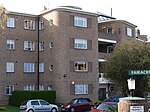 More images | |
| The Grand, Wandsworth | St Johns Hill, Clapham Junction | Theatre | 1900 | 7 April 1983 | TQ2726975368 51°27′46″N 0°10′12″W / 51.462879°N 0.170027°W / 51.462879; -0.170027 (The Grand, Wandsworth) | 1064407 |  More images |
| The Grapes, Wandsworth public house | 39 Fairfield Street, Wandsworth, London | Public house | mid-19th century | 7 April 1983 | TQ2580574854 51°27′31″N 0°11′26″W / 51.4586°N 0.1905°W / 51.4586; -0.1905 (The Grapes, Wandsworth public house) | 1065528 |  More images |
| King's Head, Roehampton public house | 1 Roehampton High Street, Roehampton, London SW15 4HL | Public house | 17th century | 14 July 1955 | TQ2234273834 51°27′01″N 0°14′27″W / 51.450283°N 0.240766°W / 51.450283; -0.240766 (King's Head, Roehampton public house) | 1300007 |  More images |
| The Kings Head Public House | 84 Upper Tooting Road, Tooting, London SW17 7PB | Public house | 1896 | 24 July 1981 | TQ2777772147 51°26′03″N 0°09′46″W / 51.4341°N 0.1627°W / 51.4341; -0.1627 (The Kings Head Public House) | 1065499 | 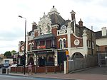 More images |
| Montague Arms | 3 Medfield Street, Roehampton, London | Public house | 17th century | 25 January 1988 | TQ2239073798 51°27′00″N 0°14′24″W / 51.449949°N 0.240088°W / 51.449949; -0.240088 (Montague Arms) | 1040283 | 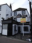 |
| Park Lodge, Putney | 289 Putney Bridge Road, Putney, London SW15 | Building | 17th century | 14 November 1988 | TQ2429075375 51°27′49″N 0°12′44″W / 51.463709°N 0.212206°W / 51.463709; -0.212206 (Park Lodge, Putney) | 1225967 |  More images |
| The Pines, Putney | 11 Putney Hill, Putney, London | House | 1870 | 7 April 1983 | TQ2396774974 51°27′26″N 0°13′09″W / 51.457285°N 0.219107°W / 51.457285; -0.219107 (The Pines, Putney) | 1065520 |  More images |
| Priory Hospital | Roehampton | Hospital | 1872 | 18 February 1975 | TQ2152575185 51°27′46″N 0°15′07″W / 51.46265°N 0.25204°W / 51.46265; -0.25204 (Priory Hospital) | 1184609 |  More images |
| Putney Bridge | Putney Bridge SW6 | Bridge | 29 May 1886 | 7 April 1983 | TQ2424775760 51°28′01″N 0°12′47″W / 51.466944°N 0.213056°W / 51.466944; -0.213056 (Putney Bridge) | 1079799 |  More images |
| Putney Library | Disraeli Road, Putney | Library | 1899 | 13 December 1994 | TQ2403575146 51°27′42″N 0°12′57″W / 51.461707°N 0.215955°W / 51.461707; -0.215955 (Putney Library) | 1331702 |  More images |
| Putney Park House | 69 Pleasance Road, Roehampton | House | Built 1837–38 | 23 July 1983 | TQ2256774953 51°27′37″N 0°14′14″W / 51.460292°N 0.23714225°W / 51.460292; -0.23714225 (Putney Park House) | 1300065 |  More images |
| Raven Inn public house | 140 Westbridge Road, Battersea, London SW11 | Public house | Late 17th century | 28 June 1954 | TQ2684776737 51°28′31″N 0°10′30″W / 51.475382°N 0.174929°W / 51.475382; -0.174929 (Raven Inn public house) | 1299760 |  More images |
| Rosslyn Tower | St John's Avenue, Putney | House | 1870 | 5 July 1974 | TQ2407374906 51°27′36″N 0°13′01″W / 51.459907°N 0.217048°W / 51.459907; -0.217048 (Rosslyn Tower) | 1357696 |  More images |
| Spread Eagle public house | 69–71 Wandsworth High Street, Wandsworth | Public house | Late 19th century | 7 April 1983 | TQ2568874616 51°27′24″N 0°11′32″W / 51.456605°N 0.192289°W / 51.456605; -0.192289 (Spread Eagle public house) | 1065502 |  More images |
| St Thomas a Becket | West Hill, Wandsworth, London SW18 | Church | 1895 | 7 April 1983 | TQ2507674656 51°27′25″N 0°12′04″W / 51.457074°N 0.201151°W / 51.457074; -0.201151 (St Thomas a Becket) | 1065467 |  More images |
| Thornhill House | 78 Deodar Road, Putney, London SW15 | House | Late 19th century | 16 April 2004 | TQ2454575353 51°27′48″N 0°12′31″W / 51.463455°N 0.208545°W / 51.463455; -0.208545 (Thornhill House) | 1390837 |  More images |
| Three Standing Figures 1947 | Battersea Park | Sculpture | 1948 | 29 March 1988 | TQ2817877118 51°28′41″N 0°09′25″W / 51.4781°N 0.1569°W / 51.4781; -0.1569 (Three Standing Figures 1947) | 1357691 |  More images |
| Wandsworth Common Windmill | Wandsworth Common | Windmill | 19th century | 7 March 1983 | TQ2680574465 51°27′18″N 0°10′35″W / 51.454973°N 0.176347°W / 51.454973; -0.176347 (Wandsworth Common Windmill) | 1183658 |  More images |
| West Hill | 29 and 31, WEST HILL SW18 | Building | Early 19th century | 7 April 1983 | TQ2517374622 51°27′24″N 0°11′59″W / 51.456747°N 0.199769°W / 51.456747; -0.199769 (West Hill) | 1065464 |  More images |
| The White Lion public house | 14–16 High Street, Putney | Public house | Built 1887 | 7 April 1983 | TQ2411475596 51°27′57″N 0°12′53″W / 51.465734°N 0.214661°W / 51.465734; -0.214661 (The White Lion public house) | 1184658 |  More images |
| Winchester House | 10 Lower Richmond Road, Putney | House | 18th century | 14 July 1955 | TQ2391875774 51°28′03″N 0°13′03″W / 51.467376°N 0.217418°W / 51.467376; -0.217418 (Winchester House) | 1300160 |  More images
|
| 23 Oakhill Road | Oakhill Road, Putney, London SW15 | House | Late 19th century | 24 February 1970 | TQ2473674903 51°27′34″N 0°12′21″W / 51.459369°N 0.205955°W / 51.459369; -0.205955 (23 Oakhill Road) | 1184564 |  More images |
| 25 Oakhill Road | Oakhill Road, Putney, London SW15 | House | Late 19th century | 24 February 1970 | TQ2475474904 51°27′34″N 0°12′21″W / 51.459374°N 0.205696°W / 51.459374; -0.205696 (25 Oakhill Road) | 1065513 |  More images |
| 92 St John's Hill | Battersea, London SW11 | House | Built 1909 | 7 April 1983 | TQ2688275144 51°27′40″N 0°10′30″W / 51.461058°N 0.174996°W / 51.461058; -0.174996 (92 St John's Hill) | 1184815 |  More images |
| 155–171 Oakhill Road | 155–171, OAKHILL ROAD | Cottages | Built 1906 | 24 March 2011 | TQ2516074957 51°27′35″N 0°11′59″W / 51.459761°N 0.199836°W / 51.459761; -0.199836 (155–171 Oakhill Road) | 1242951 |  More images |
See also
Notes
- ^ The date given is the date used by Historic England as significant for the initial building or that of an important part in the structure's description.
- ^ Sometimes known as OSGB36, the grid reference is based on the British national grid reference system used by the Ordnance Survey.
- ^ The "List Entry Number" is a unique number assigned to each listed building and scheduled monument by Historic England.
External links
 Media related to Grade II listed buildings in the London Borough of Wandsworth at Wikimedia Commons
- v
- t
- e
- Balham
- Battersea
- Clapham
- Earlsfield
- Furzedown
- Nine Elms
- Putney
- Putney Heath
- Putney Vale
- Roehampton
- Southfields
- Streatham Park
- Summerstown
- Tooting (including Tooting Graveney and Upper Tooting)
- Wandsworth
- West Hill


- Battersea Arts Centre
- Battersea Power Station
- Bridge Lane Theatre
- Chrysalis Theatre
- De Morgan Centre
- Grace Theatre
- New Covent Garden Market
- New Wandsworth Museum
- Pump House Gallery
- Theatre503
- Theatre of the Dispossessed
- Battersea
- Putney
- Tooting

 Balham
- Battersea Park
- Battersea Power Station
-
 Clapham Junction
 - Clapham South
- Earlsfield
- East Putney
- Nine Elms
- Putney
- Queenstown Road (Battersea)
- Southfields
- Tooting (in LB of Merton)
- Tooting Bec
- Tooting Broadway
- Wandsworth Common
- Wandsworth Town


- Council
- Listed buildings
- Grade I and II*
- Grade II
- People
- Public art
- Schools
 Category
- Commons

Portals:
 London
 Architecture


