Grade II* listed buildings in Kirklees
Map all coordinates using OpenStreetMap
Download coordinates as:
- KML
- GPX (all coordinates)
- GPX (primary coordinates)
- GPX (secondary coordinates)
There are over 20,000 Grade II* listed buildings in England. This page is a list of these buildings in the metropolitan borough of Kirklees in West Yorkshire.
List
| Name | Location | Type | Completed [note 1] | Date designated | Grid ref.[note 2] Geo-coordinates | Entry number [note 3] | Image |
|---|---|---|---|---|---|---|---|
| Cruck Barn Adjoining and to North of Nether End Farmhouse | Nether End, Denby Dale, Kirklees | Cruck Barn | 16th century or Early 17th century | 15 August 1985 | SE2465107863 53°34′00″N 1°37′45″W / 53.566804°N 1.629269°W / 53.566804; -1.629269 (Cruck Barn Adjoining and to North of Nether End Farmhouse) | 1135327 |  Upload Photo |
| Thorncliffe Grange Farmhouse | Emley, Denby Dale, Kirklees | House | Soon after 1623 | 29 March 1965 | SE2500613441 53°37′01″N 1°37′24″W / 53.616922°N 1.623464°W / 53.616922; -1.623464 (Thorncliffe Grange Farmhouse) | 1299857 | Upload Photo |
| Wheatley Hill Farmhouse | Denby Dale, Denby Dale, Kirklees | Farmhouse | 16th century | 29 March 1965 | SE2526009795 53°35′03″N 1°37′12″W / 53.58414°N 1.619918°W / 53.58414; -1.619918 (Wheatley Hill Farmhouse) | 1299789 | Upload Photo |
| 33, 35, 37, 39 Totties Lane | Totties, Holme Valley, Kirklees | House | later alterations | 4 August 1983 | SE1571708227 53°34′14″N 1°45′51″W / 53.570417°N 1.764143°W / 53.570417; -1.764143 (33, 35, 37, 39 Totties Lane) | 1228692 | 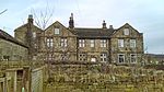 |
| Church of St John Baptist | Kirkheaton, Kirkburton, Kirklees | Tower | Perpendicular | 23 June 1965 | SE1788517222 53°39′04″N 1°43′51″W / 53.651196°N 1.730893°W / 53.651196; -1.730893 (Church of St John Baptist) | 1135391 |  More images |
| Old Milestone | Farnley Moor End, Kirkburton, Kirklees | Sundial | 1738 | 23 June 1965 | SE1662711497 53°35′59″N 1°45′01″W / 53.59978°N 1.750229°W / 53.59978; -1.750229 (Old Milestone) | 1135350 |  More images |
| Shelley Hall | Shelley, Kirkburton, Kirklees | House | Post 1699 | 23 June 1965 | SE2073411210 53°35′49″N 1°41′17″W / 53.597055°N 1.688189°W / 53.597055; -1.688189 (Shelley Hall) | 1313319 | Upload Photo |
| Healey House | Meltham, Kirklees | House | Late 18th century | 6 April 1967 | SE1061710751 53°35′36″N 1°50′28″W / 53.59323°N 1.841068°W / 53.59323; -1.841068 (Healey House) | 1183868 | Upload Photo |
| Church of St Mary | Mirfield, Kirklees | Church | 1871 | 14 March 1966 | SE2114820413 53°40′47″N 1°40′53″W / 53.679756°N 1.681311°W / 53.679756; -1.681311 (Church of St Mary) | 1134677 |  More images |
| Hopton Congregational Church | Mirfield, Kirklees | School | 1829 | 30 April 1982 | SE2011319227 53°40′09″N 1°41′49″W / 53.669137°N 1.697057°W / 53.669137; -1.697057 (Hopton Congregational Church) | 1134675 | 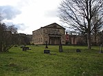 More images |
| The Old Rectory | Mirfield, Kirklees | House | Early 16th century | 14 March 1966 | SE2098320253 53°40′42″N 1°41′02″W / 53.678325°N 1.68382°W / 53.678325; -1.68382 (The Old Rectory) | 1300318 | 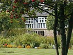 More images |
| Arts Centre Including Dwarf Wall Enclosing Queens Square | Kirklees | Gate Pier | 1819 | 11 June 1975 | SE1464816538 53°38′43″N 1°46′48″W / 53.645148°N 1.779897°W / 53.645148; -1.779897 (Arts Centre Including Dwarf Wall Enclosing Queens Square) | 1231218 |  More images |
| Bagshaw Museum, the Woodlands | Wilton Park, Kirklees | House | 1875 | 13 May 1998 | SE2349425778 53°43′40″N 1°38′43″W / 53.727877°N 1.645391°W / 53.727877; -1.645391 (Bagshaw Museum, the Woodlands) | 1119738 | 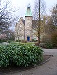 More images |
| Banqueting House in Grounds of Batley Hall | Upper Batley, Kirklees | Banqueting House | 17th century | 13 January 1984 | SE2431325437 53°43′29″N 1°37′59″W / 53.724774°N 1.633004°W / 53.724774; -1.633004 (Banqueting House in Grounds of Batley Hall) | 1313718 | Upload Photo |
| Boiler House and Engine House and Rope Race and Water Tower and Powerhouse at Westwood Mills | Linthwaite, Kirklees | Boiler House | 1826 | 20 June 2000 | SE0950214572 53°37′39″N 1°51′28″W / 53.627595°N 1.857799°W / 53.627595; -1.857799 (Boiler House and Engine House and Rope Race and Water Tower and Powerhouse at Westwood Mills) | 1271263 | Upload Photo |
| Britannia Buildings | Kirklees | Commercial Office | 1856 | 29 September 1978 | SE1443116847 53°38′53″N 1°46′59″W / 53.647932°N 1.783165°W / 53.647932; -1.783165 (Britannia Buildings) | 1232119 | 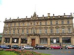 More images |
| 18th century Guide Stoop (signpost) at Junction of Crosland Road and Lindley Moor Road | Kirklees | Milestone | POST MEDIEVAL | 9 August 2011 | SE1072518979 53°40′02″N 1°50′21″W / 53.667183°N 1.839156°W / 53.667183; -1.839156 (18th century Guide Stoop (signpost) at Junction of Crosland Road and Lindley Moor Road) | 1403442 | 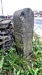 More images |
| Canal Warehouse at Aspley Basin | Kirklees | Winch | 1774-80 | 12 September 1973 | SE1493516457 53°38′40″N 1°46′32″W / 53.644412°N 1.775559°W / 53.644412; -1.775559 (Canal Warehouse at Aspley Basin) | 1223867 | 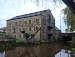 More images |
| Church of All Saints | Dewsbury, Kirklees | Dwelling | Anglo Saxon | 30 June 1949 | SE2459021524 53°41′23″N 1°37′45″W / 53.689592°N 1.629116°W / 53.689592; -1.629116 (Church of All Saints) | 1134712 | 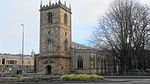 More images |
| Church of St John | Bay Hall, Kirklees | Church | 1851 | 3 March 1952 | SE1410217729 53°39′21″N 1°47′17″W / 53.655868°N 1.788103°W / 53.655868; -1.788103 (Church of St John) | 1217625 | 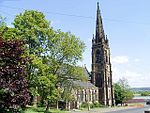 More images |
| Church of St Matthew | Rastrick, Kirklees | Church | 1875 | 3 January 1967 | SE1385421578 53°41′26″N 1°47′30″W / 53.690470°N 1.791685°W / 53.690470; -1.791685 (Church of St Matthew) | 1183810 |  More images |
| Church of St Peter | Hartshead, Kirklees | Church | Norman | 12 January 1967 | SE1790023310 53°42′21″N 1°43′49″W / 53.705915°N 1.730317°W / 53.705915; -1.730317 (Church of St Peter) | 1134588 |  More images |
| Church of St Peter | Birstall, Kirklees | Church | c. 1100 | 29 March 1963 | SE2185526179 53°43′54″N 1°40′13″W / 53.731552°N 1.670204°W / 53.731552; -1.670204 (Church of St Peter) | 1134648 | 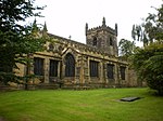 More images |
| Church of St Thomas | Huddersfield, Kirklees | Church | 1857-59 | 3 May 1952 | SE1382916225 53°38′32″N 1°47′32″W / 53.642357°N 1.7923°W / 53.642357; -1.7923 (Church of St Thomas) | 1134950 |  More images |
| Church of the Holy Trinity | Highfield, Kirklees | Parish Church | 1816-19 | 29 September 1978 | SE1378117062 53°39′00″N 1°47′35″W / 53.649882°N 1.792989°W / 53.649882; -1.792989 (Church of the Holy Trinity) | 1223128 |  More images |
| Close Gate Bridge | Marsden, Kirklees | Packhorse Bridge | 17th century or 18th century | 25 May 1966 | SE0287412100 53°36′20″N 1°57′29″W / 53.605453°N 1.95804°W / 53.605453; -1.95804 (Close Gate Bridge) | 1276561 |  More images |
| Crosland Hall | Crosland Moor, Kirklees | House | Early 17th century | 3 March 1952 | SE1104714310 53°37′31″N 1°50′04″W / 53.62521°N 1.834447°W / 53.62521; -1.834447 (Crosland Hall) | 1134305 | 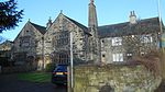 |
| Dod Lea House | Longwood, Kirklees | House | 1674 | 29 September 1978 | SE1045117129 53°39′02″N 1°50′36″W / 53.65056°N 1.843364°W / 53.65056; -1.843364 (Dod Lea House) | 1313538 | 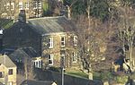 |
| Entrance Portal to Standedge Canal Tunnel | Marsden, Kirklees | Canal Tunnel | 1797-1811 | 11 July 1985 | SE0395911911 53°36′13″N 1°56′30″W / 53.603748°N 1.941645°W / 53.603748; -1.941645 (Entrance Portal to Standedge Canal Tunnel) | 1266901 | 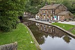 |
| Fenny Hall | Almondbury, Kirklees | House | 17th century or Early 18th century | 3 March 1952 | SE1774015206 53°37′59″N 1°44′00″W / 53.633081°N 1.733201°W / 53.633081; -1.733201 (Fenny Hall) | 1134260 |  More images |
| Highfield Farmhouse and Cottage | Birstall, Kirklees | Farmhouse | 17th century | 15 May 1980 | SE2228326687 53°44′10″N 1°39′49″W / 53.736099°N 1.66368°W / 53.736099; -1.66368 (Highfield Farmhouse and Cottage) | 1184038 | Upload Photo |
| Huddersfield Technical College (administration and Business) | Highfield, Kirklees | Steps | 1831 | 29 September 1978 | SE1407916836 53°38′52″N 1°47′19″W / 53.647842°N 1.788491°W / 53.647842; -1.788491 (Huddersfield Technical College (administration and Business)) | 1228645 |  More images |
| Lindley Clock Tower | Lindley, Kirklees | Steps | 1900-2 | 12 September 1973 | SE1188018051 53°39′32″N 1°49′18″W / 53.658817°N 1.82171°W / 53.658817; -1.82171 (Lindley Clock Tower) | 1215049 |  More images |
| Linthwaite Hall | Slaithwaite, Kirklees | Apartment | c. 1600 | 25 May 1966 | SE0849013878 53°37′17″N 1°52′23″W / 53.621375°N 1.873119°W / 53.621375; -1.873119 (Linthwaite Hall) | 1216775 |  |
| Lion Buildings | Kirklees | Statue | Modern | 29 September 1978 | SE1447316884 53°38′54″N 1°46′57″W / 53.648263°N 1.782528°W / 53.648263; -1.782528 (Lion Buildings) | 1134167 |  More images |
| Longley Old Hall | Kirklees | House | Medieval | 3 March 1952 | SE1542415015 53°37′53″N 1°46′06″W / 53.631437°N 1.768234°W / 53.631437; -1.768234 (Longley Old Hall) | 1288214 | 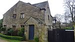 More images |
| Manor House | Slaithwaite, Kirklees | Manor House | Late 16th century | 25 May 1966 | SE0777513991 53°37′21″N 1°53′02″W / 53.622401°N 1.883926°W / 53.622401; -1.883926 (Manor House) | 1233457 | 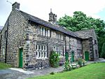 More images |
| Manor House Peel House | Gomersal, Kirklees | Manor House | Mid-late 17th century | 12 January 1967 | SE2068426758 53°44′12″N 1°41′16″W / 53.736803°N 1.687915°W / 53.736803; -1.687915 (Manor House Peel House) | 1184378 | Upload Photo |
| Mellor Bridge | Marsden, Kirklees | Packhorse Bridge | 17th century or 18th century | 25 May 1966 | SE0470211679 53°36′06″N 1°55′50″W / 53.601656°N 1.93042°W / 53.601656; -1.93042 (Mellor Bridge) | 1275335 |  More images |
| Mile Pole Adjacent to Lower Royal George Public House | Pole Moor, Kirklees | Signpost | 1755 | 11 July 1985 | SE0696916307 53°38′36″N 1°53′46″W / 53.643229°N 1.896061°W / 53.643229; -1.896061 (Mile Pole Adjacent to Lower Royal George Public House) | 1221381 | 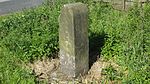 More images |
| Mill Dam at Westwood Mills | Linthwaite, Kirklees | Wall | 1801 | 20 June 2000 | SE0948214557 53°37′39″N 1°51′29″W / 53.627461°N 1.858102°W / 53.627461; -1.858102 (Mill Dam at Westwood Mills) | 1271264 | Upload Photo |
| Milnsbridge House | Milnsbridge, Kirklees | House | Early 18th century | 3 March 1952 | SE1166616033 53°38′26″N 1°49′30″W / 53.640684°N 1.825024°W / 53.640684; -1.825024 (Milnsbridge House) | 1290158 | 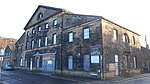 More images |
| New House Hall | Sheepridge, Kirklees | House | 1581-1638 | 3 March 1952 | SE1551119754 53°40′27″N 1°46′00″W / 53.674029°N 1.766683°W / 53.674029; -1.766683 (New House Hall) | 1279156 | Upload Photo |
| North Range at Westwood Mills | Linthwaite, Kirklees | Electricity Sub Station | C20 | 11 July 1985 | SE0949914607 53°37′40″N 1°51′28″W / 53.62791°N 1.857843°W / 53.62791; -1.857843 (North Range at Westwood Mills) | 1216965 | Upload Photo |
| Offices and Workshop Range at Westwood Mills | Linthwaite, Kirklees | Electricity Sub Station | C20 | 11 July 1985 | SE0950914593 53°37′40″N 1°51′28″W / 53.627784°N 1.857692°W / 53.627784; -1.857692 (Offices and Workshop Range at Westwood Mills) | 1217132 | Upload Photo |
| Old Hall | Birstall, Kirklees | Detached House | 1700 | 29 March 1963 | SE2239026443 53°44′02″N 1°39′43″W / 53.733902°N 1.662075°W / 53.733902; -1.662075 (Old Hall) | 1300342 | Upload Photo |
| Old Hall Farmhouse | Roberttown, Kirklees | Farmhouse | 17th century | 12 January 1967 | SE1985222984 53°42′10″N 1°42′03″W / 53.702915°N 1.700768°W / 53.702915; -1.700768 (Old Hall Farmhouse) | 1135409 |  More images |
| Old Hall Public House | Heckmondwike, Kirklees | House | 17th century | 11 June 1980 | SE2140623931 53°42′41″N 1°40′38″W / 53.711365°N 1.677164°W / 53.711365; -1.677164 (Old Hall Public House) | 1300236 |  More images |
| Parish Church of St Peter | Kirklees | Parish Church | 1834-36 | 3 March 1952 | SE1457816771 53°38′50″N 1°46′51″W / 53.647245°N 1.780945°W / 53.647245; -1.780945 (Parish Church of St Peter) | 1134977 |  More images |
| Pollard Hall | Gomersal, Kirklees | House | 1659 | 12 January 1967 | SE2082226154 53°43′53″N 1°41′09″W / 53.731369°N 1.685863°W / 53.731369; -1.685863 (Pollard Hall) | 1313297 | Upload Photo |
| Principal Mill Building at Folly Hall Mill | Kirklees | Textile Mill | Early 19th century | 29 September 1978 | SE1418015990 53°38′25″N 1°47′13″W / 53.640236°N 1.787001°W / 53.640236; -1.787001 (Principal Mill Building at Folly Hall Mill) | 1134242 |  More images |
| Providence Place United Reformed Church, Gate Piers and Gates | Cleckheaton, Kirklees | Gate | 1857-9 | 30 April 1982 | SE1907925707 53°43′39″N 1°42′44″W / 53.727418°N 1.71231°W / 53.727418; -1.71231 (Providence Place United Reformed Church, Gate Piers and Gates) | 1184234 | 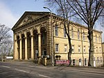 More images |
| Red House | Kirklees | House | 1660 | 12 January 1967 | SE2078526259 53°43′56″N 1°41′11″W / 53.732314°N 1.686417°W / 53.732314; -1.686417 (Red House) | 1135404 | Upload Photo |
| Rose Hill | Kirklees | House | Late 19th century | 29 September 1978 | SE1310518098 53°39′33″N 1°48′11″W / 53.65921°N 1.803172°W / 53.65921; -1.803172 (Rose Hill) | 1134389 | 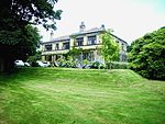 More images |
| The George Hotel | Kirklees | Hotel | 1849-50 | 20 September 1977 | SE1441816956 53°38′56″N 1°47′00″W / 53.648912°N 1.783357°W / 53.648912; -1.783357 (The George Hotel) | 1277386 | 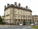 More images |
| The Second Hall (to South West of Lees Hall) | Thornhill Lees, Kirklees | House | 17th century | 30 June 1949 | SE2329619984 53°40′33″N 1°38′56″W / 53.675809°N 1.648825°W / 53.675809; -1.648825 (The Second Hall (to South West of Lees Hall)) | 1134698 | Upload Photo |
| Thorpe Farm Barn | Almondbury, Kirklees | Barn | 19th century | 3 March 1952 | SE1748215463 53°38′07″N 1°44′14″W / 53.6354°N 1.737088°W / 53.6354; -1.737088 (Thorpe Farm Barn) | 1313840 | Upload Photo |
| Upper Independent Chapel | Heckmondwike, Kirklees | Congregational Chapel | 1890 | 7 June 1978 | SE2224323716 53°42′34″N 1°39′52″W / 53.709398°N 1.664498°W / 53.709398; -1.664498 (Upper Independent Chapel) | 1134623 |  More images |
| Walton Cross 100 Yards North of Walton Cross Farmhouse | Hartshead, Kirklees | Cross | 11th century | 12 January 1967 | SE1761423792 53°42′37″N 1°44′05″W / 53.710257°N 1.734622°W / 53.710257; -1.734622 (Walton Cross 100 Yards North of Walton Cross Farmhouse) | 1313305 |  More images |
| West Block at Westwood Mills | Linthwaite, Kirklees | Carding Mill | c. 1800 | 11 July 1985 | SE0948914590 53°37′40″N 1°51′29″W / 53.627757°N 1.857995°W / 53.627757; -1.857995 (West Block at Westwood Mills) | 1216966 | Upload Photo |
| Wood End Farm | Slaithwaite, Kirklees | Farmhouse | 1626 | 11 July 1985 | SE0813814914 53°37′50″N 1°52′42″W / 53.630692°N 1.878414°W / 53.630692; -1.878414 (Wood End Farm) | 1233729 |  |
| Wormalls Hall | Almondbury, Kirklees | House | 16th century | 3 March 1952 | SE1685315006 53°37′53″N 1°44′48″W / 53.631313°N 1.746625°W / 53.631313; -1.746625 (Wormalls Hall) | 1224854 |  More images |
| 12–20 St Georges Square | Kirklees | House | Mid 19th century | 11 February 1977 | SE1432316790 53°38′51″N 1°47′05″W / 53.647422°N 1.784802°W / 53.647422; -1.784802 (12–20 St Georges Square) | 1232139 | Upload Photo |
| 7 St Georges Square | Kirklees | House | Mid 19th century | 29 September 1978 | SE1438716843 53°38′52″N 1°47′02″W / 53.647897°N 1.783831°W / 53.647897; -1.783831 (7 St Georges Square) | 1231781 |  More images |
| 42–46 Townend | Almondbury, Kirklees | House | 17th century | 29 September 1978 | SE1654715524 53°38′10″N 1°45′04″W / 53.635978°N 1.751225°W / 53.635978; -1.751225 (42–46 Townend) | 1239763 | Upload Photo |
| 2–6 Railway Street | Kirklees | House | Mid 19th century | 11 February 1977 | SE1434616762 53°38′50″N 1°47′04″W / 53.64717°N 1.784455°W / 53.64717; -1.784455 (2–6 Railway Street) | 1278114 |  |
| 8 and 10 Railway Street | Kirklees | House | Mid 19th century | 11 February 1977 | SE1434316790 53°38′51″N 1°47′04″W / 53.647422°N 1.784499°W / 53.647422; -1.784499 (8 and 10 Railway Street) | 1231473 |  More images |
| 59 Quarmby Fold | Kirklees | House | 16th century | 3 March 1952 | SE1141117258 53°39′06″N 1°49′44″W / 53.6517°N 1.828836°W / 53.6517; -1.828836 (59 Quarmby Fold) | 1230100 |  |
| 47 and 49 Quarmby Fold | Kirklees | House | 16th century | 3 March 1952 | SE1140117255 53°39′06″N 1°49′44″W / 53.651673°N 1.828987°W / 53.651673; -1.828987 (47 and 49 Quarmby Fold) | 1278771 |  More images |
Notes
- ^ The date given is the date used by Historic England as significant for the initial building or that of an important part in the structure's description.
- ^ Sometimes known as OSGB36, the grid reference is based on the British national grid reference system used by the Ordnance Survey.
- ^ The "List Entry Number" is a unique number assigned to each listed building and scheduled monument by Historic England.
External links
- v
- t
- e
- Bedfordshire
- Berkshire
- Bristol
- Buckinghamshire
- Cambridgeshire
- Cheshire
- Cornwall
- Cumbria
- Derbyshire
- Devon
- Dorset
- Durham
- East Sussex
- East Riding of Yorkshire
- Essex
- Gloucestershire
- Greater London
- Greater Manchester
- Hampshire
- Herefordshire
- Hertfordshire
- Isle of Wight
- Kent
- Lancashire
- Leicestershire
- Lincolnshire
- Merseyside
- Norfolk
- North Yorkshire
- Northamptonshire
- Northumberland
- Nottinghamshire
- Oxfordshire
- Rutland
- Shropshire
- Somerset
- South Yorkshire
- Staffordshire
- Suffolk
- Surrey
- Tyne and Wear
- Warwickshire
- West Midlands
- West Sussex
- West Yorkshire
- Wiltshire
- Worcestershire
- Allerdale
- Amber Valley
- Ashford
- Babergh
- Barrow-in-Furness
- Basildon
- Basingstoke and Deane
- Bath and North East Somerset
- Bolsover
- Boston
- Bournemouth
- Bradford
- Braintree
- Breckland
- Brentwood
- Brighton and Hove
- Bristol
- Broadland
- Calderdale
- Cambridge
- Camden
- Canterbury
- Carlisle
- Castle Point
- Chelmsford
- Cheltenham
- Cherwell
- Cheshire East
- Cheshire West and Chester
- Chesterfield
- Chiltern
- Christchurch
- Colchester
- Copeland
- Corby
- Cotswold
- Dartford
- Daventry
- Dover
- East Cambridgeshire
- Exeter
- Mendip
- North Somerset
- North Yorkshire (district)
- Poole
- Sedgemoor
- South Somerset
- Stoke-on-Trent
- Taunton Deane
- West Somerset
- York


