Grade II* listed buildings in Harlow
Map all coordinates using OpenStreetMap
Download coordinates as:
- KML
- GPX (all coordinates)
- GPX (primary coordinates)
- GPX (secondary coordinates)
There are over 20,000 Grade II* listed buildings in England. This page is a list of these buildings in the district of Harlow in Essex.
Harlow
| Name | Location | Type | Completed [note 1] | Date designated | Grid ref.[note 2] Geo-coordinates | Entry number [note 3] | Image |
|---|---|---|---|---|---|---|---|
| Barn East of Netteswellbury House | Netteswellbury, Harlow | Barn | c. 1440 | 5 July 1950 | TL4556509356 51°45′50″N 0°06′29″E / 51.763969°N 0.107948°E / 51.763969; 0.107948 (Barn East of Netteswellbury House) | 1337041 |  Upload Photo |
| Coppins | Latton, Harlow | House | 16th century | 19 June 1981 | TL4667409606 51°45′57″N 0°07′27″E / 51.765927°N 0.124112°E / 51.765927; 0.124112 (Coppins) | 1169716 | Upload Photo |
| Mulberry Green House and Stables | Mulberry Green, Harlow | House | Late 18th century | 5 July 1950 | TL4780111534 51°46′59″N 0°08′29″E / 51.782953°N 0.141252°E / 51.782953; 0.141252 (Mulberry Green House and Stables) | 1111689 |  More images |
| Hill House | Mulberry Green, Harlow | House | 18th century | 5 July 1950 | TL4782411555 51°46′59″N 0°08′30″E / 51.783136°N 0.141594°E / 51.783136; 0.141594 (Hill House) | 1337039 | Upload Photo |
| Kingsmoor House | Paringdon Rd, Harlow | House | 18th century | 19 June 1981 | TL4388607717 51°44′59″N 0°04′59″E / 51.749676°N 0.082958°E / 51.749676; 0.082958 (Kingsmoor House) | 1337043 | Upload Photo |
| Old House | Roydon Rd, Harlow | Timber Framed House | c. 1600 | 5 July 1950 | TL4205910181 51°46′20″N 0°03′27″E / 51.772282°N 0.057516°E / 51.772282; 0.057516 (Old House) | 1169770 | Upload Photo |
| The Gables | Fore St, Harlow | Cross Wing House | 15th century | 5 July 1950 | TL4718211544 51°47′00″N 0°07′56″E / 51.783206°N 0.132289°E / 51.783206; 0.132289 (The Gables) | 1169233 | 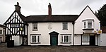 More images |
| The Queen's Head Public House | Harlow | Jettied House | Early 16th century | 5 July 1950 | TL4831011445 51°46′55″N 0°08′55″E / 51.782019°N 0.148587°E / 51.782019; 0.148587 (The Queen's Head Public House) | 1111700 | 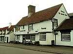 More images |
| Roman Catholic Church of Our Lady of Fatima | Howard Way, Harlow | Church | 1960 | 20 December 2000 | TL457108 51°46′37″N 0°06′40″E / 51.7769°N 0.1111°E / 51.7769; 0.1111 (Roman Catholic Church of Our Lady of Fatima) | 1246733 | 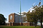 More images |
Notes
- ^ The date given is the date used by Historic England as significant for the initial building or that of an important part in the structure's description.
- ^ Sometimes known as OSGB36, the grid reference is based on the British national grid reference system used by the Ordnance Survey.
- ^ The "List Entry Number" is a unique number assigned to each listed building and scheduled monument by Historic England.
External links
- v
- t
- e
Grade II* listed buildings in England
- Bedfordshire
- Berkshire
- Bristol
- Buckinghamshire
- Cambridgeshire
- Cheshire
- Cornwall
- Cumbria
- Derbyshire
- Devon
- Dorset
- Durham
- East Sussex
- East Riding of Yorkshire
- Essex
- Gloucestershire
- Greater London
- Greater Manchester
- Hampshire
- Herefordshire
- Hertfordshire
- Isle of Wight
- Kent
- Lancashire
- Leicestershire
- Lincolnshire
- Merseyside
- Norfolk
- North Yorkshire
- Northamptonshire
- Northumberland
- Nottinghamshire
- Oxfordshire
- Rutland
- Shropshire
- Somerset
- South Yorkshire
- Staffordshire
- Suffolk
- Surrey
- Tyne and Wear
- Warwickshire
- West Midlands
- West Sussex
- West Yorkshire
- Wiltshire
- Worcestershire
- Allerdale
- Amber Valley
- Ashford
- Babergh
- Barrow-in-Furness
- Basildon
- Basingstoke and Deane
- Bath and North East Somerset
- Bolsover
- Boston
- Bournemouth
- Bradford
- Braintree
- Breckland
- Brentwood
- Brighton and Hove
- Bristol
- Broadland
- Calderdale
- Cambridge
- Camden
- Canterbury
- Carlisle
- Castle Point
- Chelmsford
- Cheltenham
- Cherwell
- Cheshire East
- Cheshire West and Chester
- Chesterfield
- Chiltern
- Christchurch
- Colchester
- Copeland
- Corby
- Cotswold
- Dartford
- Daventry
- Dover
- East Cambridgeshire
- Exeter
- Mendip
- North Somerset
- North Yorkshire (district)
- Poole
- Sedgemoor
- South Somerset
- Stoke-on-Trent
- Taunton Deane
- West Somerset
- York


