Eagle Mesa
Mountain in Utah, United States


Eagle Mesa
Location in Utah
Show map of Utah
Eagle Mesa
Eagle Mesa (the United States)
Show map of the United StatesSan Juan County, Utah, U.S.
Eagle Mesa is a 6,624-foot-elevation (2,019-meter) summit in San Juan County, Utah, United States.[1]
Description
Eagle Mesa is situated 4.5 miles (7.2 km) northeast of Oljato–Monument Valley, Utah, on Navajo Nation land. It is an iconic landform of Monument Valley and can be seen from Highway 163.[4] Precipitation runoff from this mesa's slopes drains to Mitchell Butte Wash and Train Rock Wash which are both part of the San Juan River drainage basin.[3] Topographic relief is significant as the summit rises 1,100 feet (335 meters) above surrounding terrain in 0.6 mile (1 km). The nearest higher neighbor is Brighams Tomb, 2.05 miles (3.30 km) to the east.[2] This landform's toponym has been officially adopted by the United States Board on Geographic Names.[1] Navajo names for the mesa are "Wide Rock", "Where the Eagles Roost", "Water Basket Sits", and "Trees Hanging from Surrounding Belt" because there were once numerous trees here.[5] In Navajo mythology, Eagle Mesa is a place where spirits of the deceased may go.[6] Eagle Rock Spire is a 300-ft tower on the northern tip of the mesa which requires class 5.9 climbing skill to reach the summit.[7][8] Navajo names for this spire which resembles a perched eagle include "Eagle Alongside Mesa", "Big Finger is Pointed", and Tsé Łichii Dahazkani (Elevated Red Rock Sitting Up).[5] The first ascent of the spire was made on April 23, 1970, by Fred Beckey and Eric Bjornstad.[9]
Geology
Eagle Mesa is a mesa composed of three principal strata. The bottom layer is Organ Rock Shale, the next stratum is cliff-forming De Chelly Sandstone, and the upper layer is Moenkopi Formation capped by Shinarump Conglomerate. The rock ranges in age from Permian at the bottom to Late Triassic at the top. The buttes and mesas of Monument Valley are the result of the Organ Rock Shale being more easily eroded than the overlaying sandstone.[10]
Climate
Spring and fall are the most favorable seasons to visit Eagle Mesa. According to the Köppen climate classification system, it is located in a semi-arid climate zone with cold winters and hot summers. Summers average 54 days above 90 °F (32 °C) annually, and highs rarely exceed 100 °F (38 °C). Summer nights are comfortably cool, and temperatures drop quickly after sunset. Winters are cold, but daytime highs are usually above freezing. Winter temperatures below 0 °F (−18 °C) are uncommon, though possible. This desert climate receives less than 10 inches (250 millimeters) of annual rainfall, and snowfall is generally light during the winter.[11]
Gallery
-
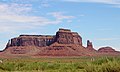
 Southwest aspect. Eagle Rock Spire to left, Setting Hen to right.
 -
 Aerial view, south aspect
 -
 Aerial view, north aspect
 -
 Southwest aspect. Eagle Rock Spire to left, Setting Hen to right.
 -
 East aspect
 -
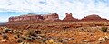
 Southwest aspect, from Highway 163
 -
 East-northeast aspect, from Highway 163. Eagle Rock Spire to right.
 -
 Eagle Mesa (left) and Setting Hen viewed from the south.


See also
References
- ^ a b c d "Eagle Mesa". Geographic Names Information System. United States Geological Survey, United States Department of the Interior. Retrieved 2024-08-23.
- ^ a b c d e "Eagle Mesa - 6,620' UT". listsofjohn.com. Retrieved 2024-08-23.
- ^ a b "Eagle Mesa, Utah". Peakbagger.com. Retrieved 2024-08-23.
- ^ American Cowboy, May-Jun 2006, Active Interest Media, Inc. p. 98.
- ^ a b Samuel Holiday, Under the Eagle: Samuel Holiday, Navajo Code Talker, University of Oklahoma Press, 2013, ISBN 9780806151038.
- ^ Robert S. McPherson Dinéjí Na`nitin: Navajo Traditional Teachings and History, University Press of Colorado, 2018, ISBN 9781607322177.
- ^ "Eagle Rock Spire, Utah". Peakbagger.com. Retrieved 2024-08-23.
- ^ "Eagle Rock Spire - 6,380' UT". listsofjohn.com. Retrieved 2024-08-23.
- ^ First Ascent Timeline, deserttowersbook.com, Retrieved 2024-08-23.
- ^ Monument Valley, Arizona, Arizona Geological Survey, Retrieved 2024-08-22.
- ^ Climate Summary for Kayenta, Arizona
External links
- Weather forecast: Eagle Mesa
- v
- t
- e
Places adjacent to Eagle Mesa
| Train Rock | Train Rock Wash | Setting Hen |
 | ||
| Mitchell Butte Wash |  Eagle Mesa Eagle Mesa | Brighams Tomb |
 | ||
| Oljato–Monument Valley | Sentinel Mesa | Highway 163 |
Portals:
 Geography
 Geology
 Utah
Utah


