Canning Parish, New Brunswick
Parish in New Brunswick, Canada
Canning | |
|---|---|
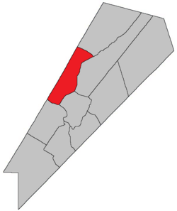 Location within Queens County, New Brunswick. | |
| Country |  Canada Canada |
| Province |  New Brunswick New Brunswick |
| County | Queens County |
| Erected | 1827 |
| Area [1] | |
| • Land | 173.25 km2 (66.89 sq mi) |
| Population (2021)[1] | |
| • Total | 1,028 |
| • Density | 5.9/km2 (15/sq mi) |
| • Change 2016-2021 |  11.3% 11.3% |
| • Dwellings | 850 |
| Time zone | UTC-4 (AST) |
| • Summer (DST) | UTC-3 (ADT) |
| Figures do not include portion within the village of Minto | |
Canning is a geographic parish in Queens County, New Brunswick, Canada.[2]
Prior to the 2023 governance reform, for governance purposes it was divided between the village of Minto and the local service district of the parish of Canning,[3] both of which were members of Capital Region Service Commission (RSC11).[4]
Origin of name
The parish was probably named in honour of George Canning, British Secretary of State for Foreign Affairs and Leader of the House of Commons at the time.[5] Shortly after the parish's erection Canning became Prime Minister of the United Kingdom.
History
Canning was erected in 1827 from Waterborough Parish.[6]
In 1835 the northwestern part of Canning was included in the newly erected Chipman Parish.[7]
Boundaries
Canning is bounded:[2][8][9][10]
- on the northeast by a line beginning on the Sunbury County line about 400 metres north-northeasterly of Minto, then running east-southeasterly for about 1.2 km before turning to run south 45º east[a] to Salmon Bay, then in a direct line to Indian Point, then into the Northeast Arm of Grand Lake;
- on the southeast by a line through Grand Lake, passing through Northeast Arm and west of Goat Island, then through the isthmus to the Saint John River, passing east of the Route 2 interchange with Route 105 and Conservation Road;
- on the southwest by the Saint John River;
- on the northwest by the Sunbury County line.
Communities
Communities at least partly within the parish.[8][9][10] bold indicates an incorporated municipality
- Clarks Corners
- Douglas Harbour
- Flowers Cove
- Maquapit Lake
- Newcastle Centre
- Newcastle Creek
- Princess Park
- Scotchtown
- Minto
- Newcastle Bridge
- Rothwell
- South Minto
Bodies of water
Bodies of water[b] at least partly within the parish.[8][9][10]
- Grand Lake Little River
- Saint John River
- Baltimore Stream
- Main Thoroughfare
- Newcastle Creek
- Otter Creek
- Coys Gut
- Back Lake
- Lower Timber Lake
- Maquapit Lake
- The Keyhole
- Grand Lake
- Douglas Harbour
- Newcastle Bay
- Northeast Arm
- Salmon Bay
Islands
Islands at least partly within the parish.[8][9][10]
- Hunters Island
- Marshalls Island
- Thatch Island
- Grand Point Bar
Other notable places
Parks, historic sites, and other noteworthy places at least partly within the parish.[8][9][10][14]
- Grand Lake Protected Natural Area
- Pickerel Pond Nature Preserve
Demographics
Parish population total does not portion within former incorporated village of Minto. Revised census figures based on the 2023 local governance reforms have not been released.
PopulationPopulation trend[15][16][17][18]
| LanguageMother tongue (2016)[18]
|

Access Routes
Highways and numbered routes that run through the parish, including external routes that start or finish at the parish limits:[19]
|
|
|
|


See also
Notes
- ^ By the magnet of 1835,[11] when declination in the area was about 17º west of north.[12] The Territorial Division Act clause referring to magnetic direction bearings was omitted in the 1952[13] and 1973 Revised Statutes.[2]
- ^ Not including brooks, ponds or coves.
References
- ^ a b "Census Profile". Statistics Canada. 26 October 2022. Retrieved 29 October 2022.
- ^ a b c "Chapter T-3 Territorial Division Act". Government of New Brunswick. Retrieved 13 November 2020.
- ^ "New Brunswick Regulation 84-168 under the Municipalities Act (O.C. 84-582)". Government of New Brunswick. Retrieved 19 July 2020.
- ^ "Communities in each of the 12 Regional Service Commissions (RSC) / Les communautés dans chacune des 12 Commissions de services régionaux (CSR)" (PDF), Government of New Brunswick, July 2017, retrieved 2 February 2021
- ^ Ganong, William F. (1896). A Monograph of the Place-Nomenclature of the Province of New Brunswick. Royal Society of Canada. p. 224. Retrieved 17 March 2021.
- ^ "8 Geo. IV c. 12 An Act for erecting the North-western part of the Town or Parish of Waterborough, in Queens County, into a separate Town or Parish.". Acts of the General Assembly of His Majesty's Province of New-Brunswick, Passed in the Year 1827. Fredericton: Government of New Brunswick. 1827. pp. 26–27. Retrieved 27 March 2021.
- ^ "5 Wm. IV c. 23 An Act for erecting parts of the Towns or Parishes of Brunswick and Canning in Queen's County into a separate Town or Parish.". Acts of the General Assembly of His Majesty's Province of New-Brunswick, Passed in the Year 1835. Fredericton: Government of New Brunswick. 1835. p. 31. Retrieved 27 March 2021.
- ^ a b c d e "No. 116". Provincial Archives of New Brunswick. Department of Natural Resources and Energy Development. Retrieved 19 June 2021. Remainder of parish on maps 127 and 128 at same site.
- ^ a b c d e "331" (PDF). Transportation and Infrastructure. Government of New Brunswick. Retrieved 19 June 2021. Remainder of parish on mapbooks 332, 352, 353, 372, 373, 392, and 393 at same site.
- ^ a b c d e "Search the Canadian Geographical Names Database (CGNDB)". Government of Canada. Retrieved 19 June 2021.
- ^ "5 Wm. IV c. 23 An Act for erecting parts of the Towns or Parishes of Brunswick and Canning in Queen's County into a separate Town or Parish.". Acts of the General Assembly of His Majesty's Province of New-Brunswick, Passed in the Year 1835. Fredericton: Government of New Brunswick. 1835. p. 31. Retrieved 27 March 2021.
- ^ "Historical Magnetic Declination". National Oceanic and Atmospheric Administration. Retrieved 25 April 2021.
- ^ "Chapter 227 Territorial Division Act". The Revised Statutes of New Brunswick 1952 Volume III. Fredericton: Government of New Brunswick. 1952. pp. 3725–3771.
- ^ "Explore New Brunswick's Protected Natural Areas". GeoNB. Retrieved 2 July 2021.
- ^ Statistics Canada: 2001, 2006 census
- ^ Profile: Canning Parish, New Brunswick
- ^ 2011 Statistics Canada Census Profile: Canning Parish, New Brunswick
- ^ a b "Census Profile, 2016 Census Canning, Parish [Census subdivision], New Brunswick". Statistics Canada. Retrieved 27 September 2019.
- ^ Atlantic Canada Back Road Atlas ISBN 978-1-55368-618-7
Places adjacent to Canning Parish, New Brunswick | |
|---|---|


- v
- t
- e
Subdivisions of New Brunswick
- Beaurivage
- Belle-Baie
- Cap-Acadie
- Caraquet
- Carleton North
- Champdoré
- Grand Bay–Westfield
- Grand Falls
- Grand-Bouctouche
- Hampton
- Hartland
- Hautes-Terres
- Heron Bay
- Île-de-Lamèque
- Oromocto
- Quispamsis
- Riverview
- Rivière-du-Nord
- Rothesay
- Saint-Quentin
- Salisbury
- Shediac
- Shippagan
- St. Andrews
- St. Stephen
- Sussex
- Tantramar
- Vallée-des-Rivières
- Woodstock
- Acadian Peninsula
- Capital Region
- Chaleur
- Fundy
- Greater Miramichi
- Kent
- Kings
- Northwest
- Restigouche
- Southeast
- Southwest
- Western Valley
- Big Hole Tract 8 (North Half)
- Big Hole Tract 8 (South Half)
- Buctouche 16
- Buctouche Micmac Band Extension
- Devon 30
- Eel Ground 2
- Eel River 3
- Esgenoôpetitj
- Fort Folly 1
- Indian Island 28
- Indian Point 1
- Indian Ranch
- Kingsclear 6
- Metepenagiag Urban Reserve 3
- Metepenagiag Urban Reserve 8
- Metepenagiag Uta'nk
- Moose Meadows 4
- Oinpegitjoig
- Oromocto 26
- Pabineau 11
- Pokemouche 13
- Red Bank 4
- Red Bank 7
- Renous 12
- Richibucto 15
- Soegao No. 35
- St Basile 10
- St. Mary's 24
- Tabusintac 9
- The Brothers 18
- Tobique 20
- Woodstock 23
 Category:New Brunswick
 Portal:Canada
 WikiProject:New Brunswick


45°58′00″N 66°05′30″W / 45.9666°N 66.0917°W / 45.9666; -66.0917


