Burnwell, Alabama
Unincorporated community in Alabama, United States
33°42′28″N 87°05′15″W / 33.70778°N 87.08750°W / 33.70778; -87.0875035038
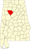
Burnwell is an unincorporated community in Walker County, Alabama, United States, located on the southern border of Dora. Burnwell had a post office from May 21, 1910, to December 30, 2010; it still has its own ZIP code, 35038.[2][3]
References
- ^ "Burnwell". Geographic Names Information System. United States Geological Survey, United States Department of the Interior.
- ^ United States Postal Service (2012). "USPS - Look Up a ZIP Code". Retrieved February 15, 2012.
- ^ "Postmaster Finder - Post Offices by ZIP Code". United States Postal Service. Archived from the original on April 28, 2019. Retrieved June 6, 2013.
- v
- t
- e
Municipalities and communities of Walker County, Alabama, United States
County seat: Jasper
communities
‡This populated place also has portions in an adjacent county or counties
- Alabama portal
- United States portal
 | This Walker County, Alabama state location article is a stub. You can help Wikipedia by expanding it. |
- v
- t
- e


