Bodzianske Lúky
Municipality in Slovakia
Bodzianske Lúky Bogyarét | |
|---|---|
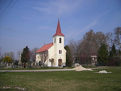 Church of Our Lady of the Rosary | |
 Flag  Coat of arms | |
47°53′N 17°54′E / 47.89°N 17.90°E / 47.89; 17.90 | |
| Country |  Slovakia Slovakia |
| Region |  Nitra Region Nitra Region |
| District | Komárno District |
| First mentioned | 1387 |
| Government | |
| • Mayor | Mónika Aradi (SMK-MKP) |
| Area [1] | |
| • Total | 5.17 km2 (2.00 sq mi) |
| Elevation [2] | 109 m (358 ft) |
| Population (2021)[3] | |
| • Total | 178 |
| Time zone | UTC+1 (CET) |
| • Summer (DST) | UTC+2 (CEST) |
| Postal code | 946 16[2] |
| Area code | +421 35[2] |
| Car plate | KN |
| Website | www.bodzianskeluky.sk |
Bodzianske Lúky (Hungarian: Bogyarét) is a village and municipality in the Komárno District in the Nitra Region of south-west Slovakia.
Geography
The village lies at an altitude of 109 metres and covers an area of 5.166 km2. It has a population of about 220 people.
History
In the 9th century, the territory of Bodzianske Lúky became part of the Kingdom of Hungary. In historical records the village was first mentioned in 1387. After the Austro-Hungarian army disintegrated in November 1918, Czechoslovak troops occupied the area, later acknowledged internationally by the Treaty of Trianon. Between 1938 and 1945 Bodzianske Lúky once more became part of Miklós Horthy's Hungary through the First Vienna Award. From 1945 until the Velvet Divorce, it was part of Czechoslovakia. Since then it has been part of Slovakia.
Ethnicity
The village is about 95% Hungarian, 5% Slovak.
Facilities
The village has a public library, and a football pitch.
References
- ^ "Hustota obyvateľstva - obce [om7014rr_ukaz: Rozloha (Štvorcový meter)]". www.statistics.sk (in Slovak). Statistical Office of the Slovak Republic. 2022-03-31. Retrieved 2022-03-31.
- ^ a b c "Základná charakteristika". www.statistics.sk (in Slovak). Statistical Office of the Slovak Republic. 2015-04-17. Retrieved 2022-03-31.
- ^ "Počet obyvateľov podľa pohlavia - obce (ročne)". www.statistics.sk (in Slovak). Statistical Office of the Slovak Republic. 2022-03-31. Retrieved 2022-03-31.
External links
- https://web.archive.org/web/20071116010355/http://www.statistics.sk/mosmis/eng/run.html
- v
- t
- e
Municipalities of Komárno District

- Bajč
- Bátorove Kosihy
- Bodza
- Bodzianske Lúky
- Brestovec
- Búč
- Čalovec
- Číčov
- Dedina Mládeže
- Dulovce
- Holiare
- Chotín
- Imeľ
- Iža
- Kameničná
- Klížska Nemá
- Kravany nad Dunajom
- Lipové
- Marcelová
- Martovce
- Moča
- Modrany
- Mudroňovo
- Okoličná na Ostrove
- Patince
- Pribeta
- Radvaň nad Dunajom
- Sokolce
- Svätý Peter
- Šrobárová
- Tôň
- Trávnik
- Veľké Kosihy
- Virt
- Vrbová nad Váhom
- Zemianska Olča
- Zlatná na Ostrove
| Authority control databases |
|
|---|
 | This Nitra Region geography article is a stub. You can help Wikipedia by expanding it. |
- v
- t
- e


