Bodza
Municipality of Slovakia
Municipality in Slovakia
Bodza Bogya | |
|---|---|
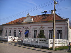 Municipal office | |
 Flag  Coat of arms | |
47°50′N 17°50′E / 47.83°N 17.83°E / 47.83; 17.83 | |
| Country |  Slovakia Slovakia |
| Region |  Nitra Region Nitra Region |
| District | Komárno District |
| First mentioned | 1387 |
| Government | |
| • Mayor | Zuzana Fitosová (MOST-HÍD) |
| Area [1] | |
| • Total | 6.32 km2 (2.44 sq mi) |
| Elevation [2] | 110 m (360 ft) |
| Population (2021)[3] | |
| • Total | 384 |
| Time zone | UTC+1 (CET) |
| • Summer (DST) | UTC+2 (CEST) |
| Postal code | 946 16[2] |
| Area code | +421 35[2] |
| Car plate | KN |
| Website | www.bodza.sk |
Bodza (Hungarian: Bogya, Hungarian pronunciation: [ˈboɟɒ]) is a village and municipality in the Komárno District in the Nitra Region of south-west Slovakia.
Geography
The village lies at an altitude of 109 metres and covers an area of 6.318 km². It had a population of about 355 people as at 31 December 2004.
History
In the 9th century, the territory of Bodza became part of the Kingdom of Hungary. In historical records the village was first mentioned in 1245. After the Austro-Hungarian army disintegrated in November 1918, Czechoslovak troops occupied the area, later acknowledged internationally by the Treaty of Trianon. Between 1938 and 1945 Bodza once more became part of Miklós Horthy's Hungary through the First Vienna Award. From 1945 until the Velvet Divorce, it was part of Czechoslovakia. Since then it has been part of Slovakia.
Facilities
The village has a football pitch.
Genealogical resources
The records for genealogical research are available at the state archive "Statny Archiv in Bratislava, Nitra, Slovakia"
- Roman Catholic church records (births/marriages/deaths): 1750-1939 (parish B)
- Reformated church records (births/marriages/deaths): 1783-1918 (parish B)
See also
References
- ^ "Hustota obyvateľstva - obce [om7014rr_ukaz: Rozloha (Štvorcový meter)]". www.statistics.sk (in Slovak). Statistical Office of the Slovak Republic. 2022-03-31. Retrieved 2022-03-31.
- ^ a b c "Základná charakteristika". www.statistics.sk (in Slovak). Statistical Office of the Slovak Republic. 2015-04-17. Retrieved 2022-03-31.
- ^ "Počet obyvateľov podľa pohlavia - obce (ročne)". www.statistics.sk (in Slovak). Statistical Office of the Slovak Republic. 2022-03-31. Retrieved 2022-03-31.
External links
- Surnames of living people in Bodza
- v
- t
- e
Municipalities of Komárno District

- Bajč
- Bátorove Kosihy
- Bodza
- Bodzianske Lúky
- Brestovec
- Búč
- Čalovec
- Číčov
- Dedina Mládeže
- Dulovce
- Holiare
- Chotín
- Imeľ
- Iža
- Kameničná
- Klížska Nemá
- Kravany nad Dunajom
- Lipové
- Marcelová
- Martovce
- Moča
- Modrany
- Mudroňovo
- Okoličná na Ostrove
- Patince
- Pribeta
- Radvaň nad Dunajom
- Sokolce
- Svätý Peter
- Šrobárová
- Tôň
- Trávnik
- Veľké Kosihy
- Virt
- Vrbová nad Váhom
- Zemianska Olča
- Zlatná na Ostrove
| Authority control databases: National |
|
|---|
 | This Nitra Region geography article is a stub. You can help Wikipedia by expanding it. |
- v
- t
- e


