Big Cone
44°25′03″N 110°34′14″W / 44.4175994°N 110.5705999°W / 44.4175994; -110.5705999[1]Elevation 7,864 feet (2,397 m)[2] Type Cone-type Geyser Eruption height <1 foot Frequency Rare Discharge Seeping 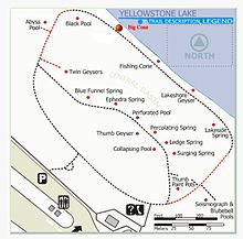
Structures and history 
West Thumb Geyser Basin Geography and geology

West Thumb Geyser Basin
Big Cone is a geyser in the West Thumb Geyser Basin of Yellowstone National Park in the United States.
Big Cone is a 7 metres (23 ft) wide sinter cone that rises from Yellowstone Lake about 7 metres (23 ft) from the shoreline. The vent of the cone is 80 centimetres (31 in) wide.[1] At times of increased water level in the lake, the cone may be submerged completely.[1][3] Big Cone is known to undergo rare eruptions 1 foot high or less.[citation needed]
References
- ^ a b c "Big Cone". Yellowstone Geothermal Features Database. Montana State University.
- ^ "Big Cone". Geographic Names Information System. United States Geological Survey, United States Department of the Interior.
- ^ "Big Cone". West Thumb Geyser Basin Tour. National Park Service. Archived from the original on 2010-05-21.
- v
- t
- e
Yellowstone National Park – lake and environs
Historic structures and other attractions in the Yellowstone Lake, West Thumb, South and East Entrance areas
- Fishing Bridge Museum
- Grand Loop Road
- Grant Village
- Lake Hotel
- Lake Fish Hatchery Historic District
- Norris, Madison, and Fishing Bridge Museums

- Abyss Pool
- Big Cone
- Black Pool
- Fishing Cone
- Barlow Peak
- Buffalo Bill Cody Scenic Byway
- Cody, Wyoming
- Colter Peak
- Eagle Peak (Wyoming)
- Factory Hill
- Hayden Valley
- Heart Lake
- Heart River (Wyoming)
- Jackson, Wyoming
- Lewis Falls
- Lewis Lake
- Lewis River
- Mount Chittenden
- Mount Doane
- Mount Hancock
- Mount Schurz
- Mount Sheridan
- Mount Stevenson
- Orange Mound Spring
- Shoshone Lake
- Snake River
- Sulphur Spring
- Sylvan Pass
- Yellowstone Lake
- Yellowstone River


