Anilio, Ioannina
Community in Greece
Anilio Ανήλιο Chiarã | |
|---|---|
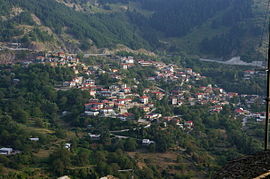 A view of Anilio. | |
| 39°45.55′N 21°11.3′E / 39.75917°N 21.1883°E / 39.75917; 21.1883 | |
| Country | Greece |
| Administrative region | Epirus |
| Regional unit | Ioannina |
| Municipality | Metsovo |
| Municipal unit | Metsovo |
| Area | |
| • Community | 42.637 km2 (16.462 sq mi) |
| Elevation | 1,050 m (3,440 ft) |
| Population (2021)[1] | |
| • Community | 548 |
| • Density | 13/km2 (33/sq mi) |
| Time zone | UTC+2 (EET) |
| • Summer (DST) | UTC+3 (EEST) |
| Postal code | 442 00 |
| Area code(s) | +30-2656 |
| Vehicle registration | ΙΝ |
Anilio (Greek: Ανήλιο, Aromanian: Chiarã) is an Aromanian village[2] and a community of the Metsovo municipality.[3] Since the 2011 local government reform it is part of the municipality Metsovo, of which it is a municipal district.[3] The 2021 census recorded 548 residents in Anilio.[1] The community of Anilio covers an area of 42.637 km2.[4]
Notable people
- Anastasios Manakis (1790–1864), revolutionary of the Greek War of Independence
See also
References
- ^ a b "Αποτελέσματα Απογραφής Πληθυσμού - Κατοικιών 2021, Μόνιμος Πληθυσμός κατά οικισμό" [Results of the 2021 Population - Housing Census, Permanent population by settlement] (in Greek). Hellenic Statistical Authority. 29 March 2024.
- ^ Ethnicity, identity and language: The case of the Vlachs/Aromanians of Metsovo. p. 247. "[...] although other Vlach villages, at least the neighbouring ones, e.g. Anilio and Milia [...]".
- ^ a b "ΦΕΚ B 1292/2010, Kallikratis reform municipalities" (in Greek). Government Gazette.
- ^ "Population & housing census 2001 (incl. area and average elevation)" (PDF) (in Greek). National Statistical Service of Greece. Archived (PDF) from the original on 2015-09-21.
- v
- t
- e
Subdivisions of the municipality of Metsovo
- Chrysovitsa
- Megali Gotista
- Mega Peristeri
- Mikra Gotista
- Mikro Peristeri
- Sitsaina
- Anilio
- Anthochori
- Metsovo
- Votonosi
 | This Epirus location article is a stub. You can help Wikipedia by expanding it. |
- v
- t
- e


