Alabaster Peak
Mountain summit in Alaska, United States


Alabaster Peak
Location of Alabaster Peak in Alaska
Alabaster Peak is an 8,065-foot-elevation (2,458-meter) mountain summit located 35 miles (56 km) east of Palmer, in the northern Chugach Mountains of Alaska. This peak of the Matanuska Valley is set midway between Anchorage and Glennallen, and can be seen from the Glenn Highway. It is situated 15 miles (24 km) west of Matanuska Glacier and 1.8 miles (2.9 km) south of Awesome Peak.[2] Precipitation runoff from the mountain drains into Coal, Monument, and Gravel creeks, which are tributaries of the Matanuska River. Topographic relief is significant as the summit rises 3,065 feet (934 meters) along the west slope in one mile (1.6 km). The first ascent of the summit was made on July 4, 1970, by Robert Spurr, Bob Pelz, and Royce Purinton via the Spectrum Glacier and North Ridge.[4][5] This mountain's toponym has not been officially adopted by the United States Board on Geographic Names, so it is only marked as "8065" on USGS maps.
Climate
Based on the Köppen climate classification, Alabaster Peak is located in a subarctic climate zone with long, cold, snowy winters, and mild summers.[6] Weather systems coming off the Gulf of Alaska are forced upwards by the Chugach Mountains (orographic lift), causing heavy precipitation in the form of rainfall and snowfall. Winter temperatures can drop below 0 °F with wind chill factors below −10 °F. This climate supports small unnamed glaciers and permanent snowfields on its slopes. The months May through June offer the most favorable weather for climbing or viewing.
See also
- Matanuska Formation
- Geography of Alaska
 Mountains portal

Gallery
-
 Alabaster is the white peak to left in back, Awesome Peak (center), Peak 7417 to right
 -
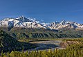 Amulet Peak (left), Matanuska River, Awesome Peak to right of center, and Alabaster Peak centered in back
 -
 Alabaster Peak centered in back, looking though valley of Monument Creek


References
- ^ a b Michael Wood and Colby Holmes, Alaska: A Climbing Guide, The Mountaineers Books, 2001, page 134.
- ^ a b c "Alabaster Peak, Alaska". Peakbagger.com. Retrieved 2024-01-27.
- ^ a b c "Alabaster Peak - 8,065' AK". listsofjohn.com. Retrieved 2024-01-27.
- ^ "Scree" (PDF). Mountaineering Club of Alaska. 1993. Retrieved 2024-01-27.
- ^ North America, United States, Alaska, "Alabaster", Northwestern Chugach, Robert Spurr, American Alpine Journal, 1971.
- ^ Peel, M. C.; Finlayson, B. L.; McMahon, T. A. (2007). "Updated world map of the Köppen−Geiger climate classification". Hydrol. Earth Syst. Sci. 11. ISSN 1027-5606.
External links
- Weather forecast: National Weather Service


