Melton (district)
Niet-metropolitaans district in Engeland  | |||
|---|---|---|---|
  | |||
| Situering | |||
| Land | Engeland | ||
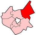
| County | Leicestershire | ||
| Regio | East Midlands | ||
| Coördinaten | 52°48'NB, 0°48'WL | ||
| Algemeen | |||
| Oppervlakte | 481,3806[1] km² | ||
| Inwoners (2018[2]) | 51.100 (106 inw./km²) | ||
| ONS-code | E07000133 | ||
| Website | Officiële website | ||
| Detailkaart | |||
 | |||
| |||

Melton is een Engels district in het shire-graafschap (non-metropolitan county OF county) Leicestershire en telt 51.000 inwoners. De oppervlakte bedraagt 481 km².
Van de bevolking is 16,1% ouder dan 65 jaar. De werkloosheid bedraagt 2,4% van de beroepsbevolking (cijfers volkstelling 2001).
Plaatsen in district Melton
- Melton Mowbray
- Waltham on the Wolds
Civil parishes in district Melton
Ab Kettleby, Asfordby, Belvoir, Bottesford, Broughton and Old Dalby, Buckminster, Burton and Dalby, Clawson, Hose and Harby, Croxton Kerrial, Eaton, Freeby, Frisby on the Wreake, Gaddesby, Garthorpe, Grimston, Hoby with Rotherby, Kirby Bellars, Knossington and Cold Overton, Redmile, Scalford, Somerby, Sproxton, Stathern, Twyford and Thorpe, Waltham on the Wolds and Thorpe Arnold, Wymondham.
Bronnen, noten en/of referenties
- Volkstelling 2001, Office for National Statistics


