Les Bottereaux
Gemeente in Frankrijk  | |||
|---|---|---|---|
  | |||
| Situering | |||
| Regio | Normandië | ||
| Departement | Eure (27) | ||
| Arrondissement | Évreux | ||
| Kanton | Breteuil | ||
| Coördinaten | 48° 53′ NB, 0° 40′ OL | ||
| Algemeen | |||
| Oppervlakte | 22,13 km² | ||
| Inwoners (1 januari 2021) | 344 (16 inw./km²) | ||
| Hoogte | 171 - 229 m | ||
| Overig | |||
| Postcode | 27250 | ||
| INSEE-code | 27096 | ||
| |||

Les Bottereaux is een gemeente in het Franse departement Eure (regio Normandië) en telt 250 inwoners (1999). De plaats maakt deel uit van het arrondissement Évreux.
-
 Kasteel van Les Bottereaux
 -
 Kerk van St Johannes de Doper


Geografie
De oppervlakte van Les Bottereaux bedraagt 21,7 km², de bevolkingsdichtheid is 11,5 inwoners per km².
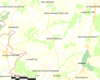
De onderstaande kaart toont de ligging van Les Bottereaux met de belangrijkste infrastructuur en aangrenzende gemeenten.
 |
Demografie
Onderstaande figuur toont het verloop van het inwonertal (bron: INSEE-tellingen).

Externe links
- (fr) Statistische informatie op de website van INSEE
Mediabestanden
Zie de categorie Les Bottereaux van Wikimedia Commons voor mediabestanden over dit onderwerp.


