Fall Creek Township (comté d'Adams, Illinois)

Cet article est une ébauche concernant l’Illinois.
Vous pouvez partager vos connaissances en l’améliorant (comment ?) selon les recommandations des projets correspondants.
| Fall Creek Township | ||||
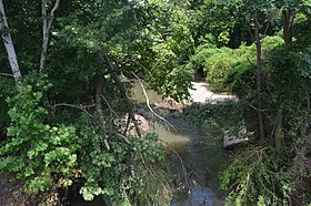 La rivière Fall Creek dans le township | ||||
| Administration | ||||
|---|---|---|---|---|
| Pays |  États-Unis États-Unis | |||
| État |  Illinois Illinois | |||
| Comté | Adams | |||
| Type de localité | Township | |||
| Code ZIP | 62301, 62338, 62359 | |||
| Code FIPS | 17-001-23412 | |||
| GNIS | 428989 | |||
| Démographie | ||||
| Population | 529 hab. (2010) | |||
| Densité | 5,3 hab./km2 | |||
| Géographie | ||||
| Coordonnées | 39° 48′ 33″ nord, 91° 20′ 12″ ouest | |||
| Altitude | 180 m | |||
| Superficie | 10 060 ha = 100,6 km2 | |||
| · dont terre | 94,4 km2 (93,84 %) | |||
| · dont eau | 6,2 km2 (6,16 %) | |||
| Fuseau horaire | CST (UTC-6) | |||
| Divers | ||||
| Fondation | 6 novembre 1849 | |||
| Localisation | ||||
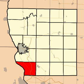 Carte du comté d'Adams. | ||||
| Géolocalisation sur la carte : États-Unis
Géolocalisation sur la carte : États-Unis
Géolocalisation sur la carte : Illinois
| ||||
modifier  | ||||


Fall Creek Township est un township du comté d'Adams dans l'Illinois, aux États-Unis[1],[2].
Références
- ↑ (en) « Fall Creek township, Adams County, Illinois (IL) detailed profile » [« Données sur Fall Creek Township, comté d'Adams, Illinois »], sur le site city-data.com (consulté le ).
- ↑ (en) « Fall Creek Township (comté d'Adams, Illinois) », Geographic Names Information System.
Articles connexes
Source de la traduction
- (en) Cet article est partiellement ou en totalité issu de l’article de Wikipédia en anglais intitulé « Fall Creek Township, Adams County, Illinois » (voir la liste des auteurs).
Municipalités et communautés du comté d'Adams (Illinois) | ||
|---|---|---|
| Siège du comté |
|  |
| Ville |
| |
| Town |
| |
| Villages |
| |
| Townships |
| |
| Secteurs non constitués en municipalité |
| |
 Portail de l’Illinois


