Whitehouse Mountain
Mountain in Ouray County, Colorado


Whitehouse Mountain
Location in Colorado
Show map of Colorado
Whitehouse Mountain
Whitehouse Mountain (the United States)
Show map of the United StatesColorado, US
San Juan Mountains
Sneffels Range[2]
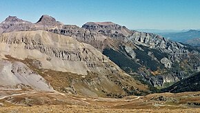
Whitehouse Mountain is a 13,492-foot-elevation (4,112-meter) mountain summit located in Ouray County of southwest Colorado, United States.[4][5] It is situated four miles west of the community of Ouray, on land managed by Uncompahgre National Forest. It is part of the Sneffels Range which is a subset of the San Juan Mountains, which in turn is part of the Rocky Mountains. It is west of the Continental Divide, 2.2 miles north of Potosi Peak, and 3.2 miles east-northeast of Mount Sneffels. Topographic relief is significant as the east aspect rises 5,680 feet (1,730 meters) above the town of Ouray in approximately four miles. The mountain's name, which has been officially adopted by the United States Board on Geographic Names, was in use before 1906 when Henry Gannett published it in the Gazetteer of Colorado.[6]
Climate
According to the Köppen climate classification system, Whitehouse Mountain is located in an alpine subarctic climate zone with long, cold, snowy winters, and cool to warm summers.[7] Due to its altitude, it receives precipitation all year, as snow in winter, and as thunderstorms in summer, with a dry period in late spring. Precipitation runoff from the mountain drains into tributaries of the Uncompahgre River.

See also
 Mountains portal
 Colorado portal


- Mountains of Ouray County, Colorado
References
- ^ Robert M. Ormes, 1997, Guide to the Colorado Mountains, Bower House, ISBN 9781555661946, page 245.
- ^ a b c "Whitehouse Mountain, Colorado". Peakbagger.com.
- ^ a b c "Whitehouse Mountain - 13,492' CO". listsofjohn.com. Retrieved 2021-07-02.
- ^ a b "Whitehouse Mountain". Geographic Names Information System. United States Geological Survey, United States Department of the Interior. Retrieved 2021-07-02.
- ^ Daniel J. Hopkins, Merriam-Webster, Inc, 1997, Merriam-Webster's Geographical Dictionary, Volume 10, page 1304.
- ^ Henry Gannett, Gazetteer of Colorado, 1906, US Government Printing Office, page 180.
- ^ Peel, M. C.; Finlayson, B. L.; McMahon, T. A. (2007). "Updated world map of the Köppen−Geiger climate classification". Hydrol. Earth Syst. Sci. 11. ISSN 1027-5606.
External links
- Weather forecast: Whitehouse Mountain
- v
- t
- e

- Mount Garfield
- Aspen Mountain
- Capitol Peak
- Castle Peak
- Cathedral Peak
- Chair Mountain
- Crested Butte
- Gothic Mountain
- Italian Mountain
- Maroon Bells
- Mount Emmons
- Mount Owen
- Mount Sopris
- Pyramid Peak
- Snowmass Mountain
- Snowmass Peak
- Treasure Mountain
- Black Mountain (Moffat County)
- Columbus Mountain
- Elk Mountain (Routt County)
- Hahns Peak
- Flat Top Mountain
- Sleepy Cat Peak
- Eagles Nest
- Jacque Peak
- Meridian Peak
- Mount Powell
- The Spider
- Crater Peak
- North Mamm Peak
- Clark Peak
- Arkansas Hills
- Clinton Peak
- Dyer Mountain
- Gemini Peak
- Horseshoe Mountain
- Mount Arkansas
- Mount Bross
- Mount Buckskin
- Mount Democrat
- Mount Lincoln
- Mount Sheridan
- Mount Sherman
- Pacific Peak
- West Buffalo Peak
- Elk Mountain (Grand County)
- Parkview Mountain
- Radial Mountain
- Whiteley Peak
| Sangre de Cristo Range |
|
|---|---|
| Wet Mountains |
|
| Others |
|
| Collegiate Peaks |
|
|---|---|
| Others |
|
- Crystal Peak
- Fletcher Mountain
- Peak 10
- Peak One
- Quandary Peak
- Tenmile Peak
- Bear Mountain
- Blair Mountain
- Chalk Mountains
- Cochetopa Hills
- Dawson Butte
- Diamond Peak
- Flirtation Peak
- Granite Peak
- Grand Hogback
- Grannys Nipple
- Horsefly Peak
- Lead Mountain (Grand County)
- Mount Neva
- Powell Peak
- San Luis Hills
- Storm King Mountain
- Terrible Mountain
- Two Buttes
- Ute Mountain


