Vrbica, Čoka
Village in Vojvodina, Serbia
Village in Vojvodina, Serbia
Vrbica Врбица (Serbian) Egyházaskér (Hungarian) Verbița (Romanian) | |
|---|---|
Village (Selo) | |
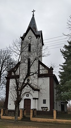 The Birth of St. John the Baptist Catholic Church | |
46°00′24″N 20°18′28″E / 46.00667°N 20.30778°E / 46.00667; 20.30778 | |
| Country |  Serbia Serbia |
| Province |  Vojvodina Vojvodina |
| Region | Banat |
| District | North Banat |
| Municipality | Čoka |
| Elevation | 69 m (226 ft) |
| Population (2011) | |
| • Vrbica | 404 |
| Time zone | UTC+1 (CET) |
| • Summer (DST) | UTC+2 (CEST) |
| Postal code | 23329 |
| Area code | +381(0)230 |
| Car plates | KI |
Vrbica (Serbian Cyrillic: Врбица, Hungarian: Egyházaskér, Romanian: Verbița) is a village in Serbia. It is situated in the Čoka municipality, North Banat District, Vojvodina province. The village has a Hungarian ethnic majority (92.07%) and its population according to the 2002 census numbering 404 people.
Historical population
- 1961: 1,220
- 1971: 988
- 1981: 654
- 1991: 548
- 2002: 404
See also
References
- Slobodan Ćurčić, Broj stanovnika Vojvodine, Novi Sad, 1996.
External links
- History of Vrbica
- v
- t
- e
Cities, towns and villages in the North Banat District
- Mol
- Obornjača
- Sterijino
- Utrine
- Adorjan
- Velebit
- Doline
- Vojvoda Zimonić
- Male Pijace
- Mali Pesak
- Martonoš
- Novo Selo
- Orom
- Totovo Selo
- Trešnjevac
- Horgoš
- Banatsko Aranđelovo
- Đala
- Majdan
- Podlokanj
- Rabe
- Siget
- Srpski Krstur
- Filić
- Banatski Monoštor
- Vrbica
- Jazovo
- Ostojićevo
- Padej
- Sanad
- Crna Bara
(*) bold are municipalities or cities
 | This North Banat District, Vojvodina location article is a stub. You can help Wikipedia by expanding it. |
- v
- t
- e


