Twining Peak
Mountain in the American state of Colorado


Twining Peak
Location in Colorado
Show map of Colorado
Twining Peak
Twining Peak (the United States)
Show map of the United StatesHunter–Fryingpan Wilderness
Sawatch Range
Twining Peak is a 13,711-foot (4,179 m) mountain summit on the shared border of Pitkin County and Lake County, in Colorado, United States.
Description
Twining Peak is set on the Continental Divide 2 miles (3.2 km) north of Independence Pass in the Sawatch Range which is a subrange of the Rocky Mountains. It ranks as the 138th-highest peak in Colorado.[3] The mountain is located 15 miles (24 km) east of the community of Aspen on land managed by White River National Forest and San Isabel National Forest. The peak is situated on the boundary shared by Mount Massive Wilderness and Hunter–Fryingpan Wilderness. Precipitation runoff from the mountain's slopes drains west into headwaters of the Roaring Fork River and east to the Arkansas River via Lake Creek. Topographic relief is significant as the summit rises 2,300 feet (701 m) above Roaring Fork River in one mile (1.6 km) and 2,500 feet (762 m) above North Fork Lake Creek in one mile (1.6 km). An ascent of the peak involves hiking four miles (6.4 km) with 1,700 feet (518 m) of elevation gain and is considered the shortest climb from a paved highway of Colorado's 200 highest peaks.[1]
Etymology
The mountain's toponym was officially adopted on January 1, 1974, by the United States Board on Geographic Names to honor Dr. Warren Hugh Twining (1876–1946), mayor of Aspen (1905–1907), member of Colorado House of Representatives (1925–34), and Speaker of the Colorado State House of Representatives (1933–34).[4] He was instrumental in establishing Western College in Gunnison.[4]
Climate
According to the Köppen climate classification system, Twining Peak is located in an alpine subarctic climate zone with cold, snowy winters, and cool to warm summers.[5] Due to its altitude, it receives precipitation all year, as snow in winter, and as thunderstorms in summer, with a dry period in late spring.
Gallery
-
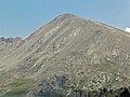
 North aspect of Twining Peak from Independence Lake
 -
 West aspect


See also
 Mountains portal
- List of mountain peaks of Colorado
- Thirteener
- Geissler Mountain

References
- ^ a b Mike Garratt, Bob Martin (1984), Colorado's High Thirteeners, Johnson Books, ISBN 9780917895395, p. 34.
- ^ a b c "Twining Peak, Colorado". Peakbagger.com. Retrieved April 6, 2023.
- ^ a b c "Twining Peak - 13,721' CO". listsofjohn.com. Retrieved April 6, 2023.
- ^ a b c "Twining Peak". Geographic Names Information System. United States Geological Survey, United States Department of the Interior. Retrieved April 6, 2023.
- ^ Peel, M. C.; Finlayson, B. L.; McMahon, T. A. (2007). "Updated world map of the Köppen−Geiger climate classification". Hydrol. Earth Syst. Sci. 11. ISSN 1027-5606.
External links
- Twining Peak: weather forecast
- v
- t
- e

- Mount Garfield
- Aspen Mountain
- Capitol Peak
- Castle Peak
- Cathedral Peak
- Chair Mountain
- Crested Butte
- Gothic Mountain
- Italian Mountain
- Maroon Bells
- Mount Emmons
- Mount Owen
- Mount Sopris
- Pyramid Peak
- Snowmass Mountain
- Snowmass Peak
- Treasure Mountain
- Black Mountain (Moffat County)
- Columbus Mountain
- Elk Mountain (Routt County)
- Hahns Peak
- Flat Top Mountain
- Sleepy Cat Peak
- Eagles Nest
- Jacque Peak
- Meridian Peak
- Mount Powell
- The Spider
- Crater Peak
- North Mamm Peak
- Clark Peak
- Arkansas Hills
- Clinton Peak
- Dyer Mountain
- Gemini Peak
- Horseshoe Mountain
- Mount Arkansas
- Mount Bross
- Mount Buckskin
- Mount Democrat
- Mount Lincoln
- Mount Sheridan
- Mount Sherman
- Pacific Peak
- West Buffalo Peak
- Elk Mountain (Grand County)
- Parkview Mountain
- Radial Mountain
- Whiteley Peak
| Sangre de Cristo Range |
|
|---|---|
| Wet Mountains |
|
| Others |
|
| Collegiate Peaks |
|
|---|---|
| Others |
|
- Crystal Peak
- Fletcher Mountain
- Peak 10
- Peak One
- Quandary Peak
- Tenmile Peak
- Bear Mountain
- Blair Mountain
- Chalk Mountains
- Cochetopa Hills
- Dawson Butte
- Diamond Peak
- Flirtation Peak
- Granite Peak
- Grand Hogback
- Grannys Nipple
- Horsefly Peak
- Lead Mountain (Grand County)
- Mount Neva
- Powell Peak
- San Luis Hills
- Storm King Mountain
- Terrible Mountain
- Two Buttes
- Ute Mountain


