Tinkham Peak
Mountain in Washington (state), United States


Tinkham Peak
Location in Washington
Show map of Washington (state)
Tinkham Peak
Tinkham Peak (the United States)
Show map of the United StatesWashington state, U.S.
Tinkham Peak is a double summit mountain located on the common boundary of King County and Kittitas County in Washington state.[3]
Description
Tinkham Peak is situated on the crest of the Cascade Range, on land managed by Mount Baker-Snoqualmie National Forest and Okanogan-Wenatchee National Forest. The east summit, elevation 5,395 feet, is regarded as Tinkham Peak by the USGS, but the west summit, one-quarter mile away, is slightly higher. Tinkham Peak is situated six miles south of Snoqualmie Pass, and neighbors include Silver Peak, one mile to the north-northwest, and Abiel Peak three-quarters mile to the west. Precipitation runoff from the north and east sides of the mountain drains to Keechelus Lake via Cold Creek and Roaring Creek, whereas the south side of the mountain drains to the North Fork Cedar River. Topographic relief is significant as the south aspect rises 2,000 feet (610 meters) above the Cedar in approximately one mile. The Pacific Crest Trail traverses the flanks of the peak and provides access to the Northwest Ridge and Southeast Spur non-technical climbing routes.[4]
Etymology
This geographic landform was named by The Mountaineers and was officially adopted in 1916 by the U.S. Board on Geographic Names to honor Lieutenant Abiel W. Tinkham.[5] He worked as a railroad surveyor when he explored the Snoqualmie Pass area in 1853 and 1854. He is also the namesake of nearby Abiel Peak, and Tinkham Mountain in Glacier National Park, Montana.
Climate
Tinkham Peak is located in the marine west coast climate zone of western North America.[4] Most weather fronts originate in the Pacific Ocean, and travel east toward the Cascade Mountains. As fronts approach, they are forced upward by the peaks of the Cascade Range, causing them to drop their moisture in the form of rain or snowfall onto the Cascades (Orographic lift). As a result, the west side of the Cascades experiences high precipitation, especially during the winter months in the form of snowfall. Because of maritime influence, snow tends to be wet and heavy, resulting in avalanche danger.[4] During winter months, weather is usually cloudy, but due to high pressure systems over the Pacific Ocean that intensify during summer months, there is often little or no cloud cover during the summer.[4] The months July through September offer the most favorable weather for viewing or climbing this peak.
Gallery
-
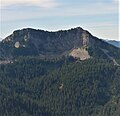 Northeast aspect of Tinkham seen from Mount Catherine
 -
 Tinkham Peak (left), Mt. Rainier, Silver Peak seen from Red Mountain
 -
 Tinkham Peak
 -
 View from Tinkham Peak looking east-southeast. Cottonwood Lake (left), Mirror Lake (bottom), Lost Lake (right of center), Keechelus Lake (top).
 -
 Tinkham Peak reflected in Mirror Lake


See also
 Mountains portal


