Timeline of the 2015 North Indian Ocean cyclone season
| Timeline of the 2015 North Indian Ocean cyclone season | |||||||
|---|---|---|---|---|---|---|---|
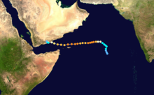
 Season summary map | |||||||
| Season boundaries | |||||||
| First system formed | June 7, 2015 | ||||||
| Last system dissipated | November 10, 2015 | ||||||
| Strongest system | |||||||
| Name | Chapala | ||||||
| Maximum winds | 215 km/h (130 mph) (3-minute sustained) | ||||||
| Lowest pressure | 940 hPa (mbar) | ||||||
| Longest lasting system | |||||||
| Name | Chapala | ||||||
| Duration | 8 days | ||||||
| |||||||
| Other years 2013, 2014, 2015, 2016, 2017 | |||||||
The 2015 North Indian Ocean cyclone season was a below-average tropical cyclone season[nb 1] which featured the highest number of deaths since the 2010 season. Despite inactivity in the Bay of Bengal caused by the ongoing El Niño, the season produced an above-average number of tropical cyclones in the Arabian Sea.[1] The first storm of the season, Ashobaa, formed on 7 June, while the final storm of the season, Megh, ultimately dissipated on 10 November.
A total of twelve depressions were recorded, of which nine intensified into deep depressions. Of these nine, a total of four further strengthened into cyclonic storms, while two attained their peaks as extremely severe cyclonic storms. In early June, Cyclonic Storm Ashobaa produced significant flooding in eastern Oman and the United Arab Emirates.[2][3][4] Later that month, Deep Depression ARB 02 resulted in the worst floods in the Amreli district of Gujarat in 90 years.[5] The storm resulted in 80 deaths and an estimated 16.5 billion Indian rupees in damage in the state.[6][7] In late July and early August, Cyclonic Storm Komen resulted in between 187 and 280 deaths in northeastern India, Bangladesh and Myanmar due to torrential rains as it slowly moved through the region. In early November, Extremely Severe Cyclonic Storm Chapala, the strongest storm of the season, became the first recorded tropical cyclone to produce hurricane-force winds in Yemen. During the storm's passage, areas in southern Yemen received 610 mm (24 in) of rainfall over 48 hours, or 700% of the average yearly precipitation.[8] Just days after Chapala produced widespread damage in Yemen and the Puntland region of Somalia, Extremely Severe Cyclonic Storm Megh passed through the same region causing further destruction. Megh was judged to have been the worst tropical cyclone ever to affect the Yemeni island of Socotra, and resulted in 18 deaths on the island.[9] The final storm of the season to form, Deep Depression BOB 03, produced significant flooding in southern India and resulted in at least 71 deaths in the region in early November.[10][11]
Within the northern Indian Ocean, tropical cyclones were monitored by the India Meteorological Department (IMD) at the Regional Specialized Meteorological Center in New Delhi. The IMD designated tropical cyclones forming in the Arabian Sea with the prefix "ARB", tropical cyclones forming in the Bay of Bengal with the prefix "BOB" and tropical cyclones forming overland with the prefix "LAND". In addition, the United States Joint Typhoon Warning Center (JTWC) issued unofficial warnings within the region, with tropical cyclones forming in the Arabian Sea assigned the suffix "A" and tropical cyclones forming in the Bay of Bengal assigned the "B" suffix. The IMD used the IMD Tropical Cyclone Intensity Scale and measured average sustained wind speeds taken over a three-minute period, while the JTWC measured average sustained wind speeds taken over a one-minute period and used the Saffir–Simpson hurricane scale.
This timeline includes information from post-storm reviews by the IMD and the JTWC. It documents tropical cyclone formations, strengthenings, weakenings, landfalls, extratropical transition, and dissipations during the season. Reports among warning centers often differ; therefore, information from both agencies has been included.
Timeline of events

June
6 June
- 06:00 UTC[nb 2] (11:30 a.m. IST[nb 3]) at 13°06′N 68°30′E / 13.1°N 68.5°E / 13.1; 68.5 (Tropical Depression 01A forms from an area of low pressure) – The Joint Typhoon Warning Center (JTWC) reports that Tropical Depression 01A has formed from an area of low pressure while located roughly 475 km (295 mi)[nb 4] northwest of Lakshadweep, India.[12]
7 June
- 03:00 UTC (8:30 a.m. IST) at 14°30′N 68°30′E / 14.5°N 68.5°E / 14.5; 68.5 (Depression ARB 01 (01A) develops from an area of low pressure) – The India Meteorological Department (IMD) designates Tropical Depression 01A as Depression ARB 01 while the system is located roughly 580 km (360 mi) west of Goa.[13]
- 06:00 UTC (11:30 a.m. IST) at 15°42′N 68°30′E / 15.7°N 68.5°E / 15.7; 68.5 (Tropical Depression ARB 01 (01A) intensifies into a tropical storm) – The JTWC reports that Tropical Depression ARB 01 (01A) has intensified into a tropical storm while located roughly 575 km (355 mi) west of Goa.[12]
8 June
- 00:00 UTC (5:30 a.m. IST) at 17°30′N 67°30′E / 17.5°N 67.5°E / 17.5; 67.5 (Depression ARB 01 (01A) intensifies into a deep depression) – The IMD reports that Depression ARB 01 (01A) has intensified into a deep depression while located roughly 510 km (315 mi) west of Porbandar, Gujarat.[13]
- 03:00 UTC (8:30 a.m. IST) at 17°54′N 67°12′E / 17.9°N 67.2°E / 17.9; 67.2 (Deep Depression ARB 01 (01A) intensifies into a cyclonic storm) – The IMD reports that Deep Depression ARB 01 (01A) has intensified into a cyclonic storm and names it "Ashobaa" while the system is located roughly 490 km (305 mi) west of Porbandar, Gujarat.[13]
9 June
- 18:00 UTC (11:30 p.m. IST) at 21°12′N 62°30′E / 21.2°N 62.5°E / 21.2; 62.5 (Cyclonic Storm Ashobaa (01A) attains its peak winds) – The IMD reports that Cyclonic Storm Ashobaa (01A) has reached its peak intensity, with maximum 3-minute sustained wind speeds of 85 km/h (55 mph), while located roughly 510 km (315 mi) southeast of Muscat, Oman.[13]
- 18:00 UTC (11:30 p.m. IST) at 21°00′N 62°42′E / 21.0°N 62.7°E / 21.0; 62.7 (Tropical Storm Ashobaa (01A) attains its peak winds) – The JTWC reports that Tropical Storm Ashobaa (01A) has reached its peak intensity, with maximum 1-minute sustained wind speeds of 105 km/h (65 mph), while located roughly 540 km (335 mi) southeast of Muscat, Oman.[12]
11 June
- 18:00 UTC (11:30 p.m. IST) at 20°48′N 59°42′E / 20.8°N 59.7°E / 20.8; 59.7 (Cyclonic Storm Ashobaa (01A) weakens into a deep depression) – The IMD reports that Cyclonic Storm Ashobaa (01A) has weakened into a deep depression while located roughly 340 km (210 mi) southeast of Muscat, Oman.[13]
12 June
- 00:00 UTC (5:30 a.m. IST) at 20°48′N 59°30′E / 20.8°N 59.5°E / 20.8; 59.5 (Deep Depression ex-Ashobaa (01A) weakens into a depression) – The IMD reports that Deep Depression ex-Ashobaa (01A) has weakened into a depression while located roughly 335 km (210 mi) southeast of Muscat, Oman.[13]
- 06:00 UTC (11:30 a.m. IST) at 20°42′N 59°48′E / 20.7°N 59.8°E / 20.7; 59.8 (Tropical Storm Ashobaa (01A) weakens into a tropical depression and dissipates) – The JTWC reports that Tropical Storm Ashobaa (01A) has weakened into a tropical depression and dissipated while located roughly 355 km (220 mi) southeast of Muscat, Oman.[12]
- 12:00 UTC (5:30 p.m. IST) at 20°48′N 59°30′E / 20.8°N 59.5°E / 20.8; 59.5 (Depression ex-Ashobaa (01A) weakens into a well-marked low-pressure area) – The IMD reports that Depression ex-Ashobaa (01A) has weakened into a well-marked low-pressure area while located roughly 335 km (210 mi) southeast of Muscat, Oman.[13]
20 June
- 03:00 UTC (8:30 a.m. IST) at 18°00′N 86°00′E / 18.0°N 86.0°E / 18.0; 86.0 (Depression BOB 01 develops from an area of low pressure) – The IMD reports that Depression BOB 01 has formed while located roughly 250 km (155 mi) south of Bhubaneswar, Odisha. Simultaneously, they report that the system has reached its peak intensity, with maximum 3-minute sustained wind speeds of 45 km/h (30 mph).[13]
- 20:00–21:00 UTC (1:30–2:30 a.m. IST, 21 June) at 19°42′N 85°00′E / 19.7°N 85.0°E / 19.7; 85.0 (Depression BOB 01 makes landfall) – The IMD reports that Depression BOB 01 has made landfall on the Odia coast between Gopalpur and Puri with maximum 3-minute sustained wind speeds of 45 km/h (30 mph).[13]
22 June
- 00:00 UTC (5:30 a.m. IST) at 21°00′N 84°30′E / 21.0°N 84.5°E / 21.0; 84.5 (Depression BOB 01 weakens into a well-marked low-pressure area) – The IMD reports that Depression BOB 01 has weakened into a well-marked low-pressure area while located over the Indian states of Odisha, Jharkhand and Chhattisgarh.[13]
- 03:00 UTC (8:30 a.m. IST) at 20°00′N 67°00′E / 20.0°N 67.0°E / 20.0; 67.0 (Depression ARB 02 develops from an area of low pressure) – The IMD reports that Depression ARB 02 has formed while located roughly 330 km (205 mi) southwest of Porbandar, Gujarat.[13]
23 June
- 03:00 UTC (8:30 a.m. IST) at 20°30′N 70°30′E / 20.5°N 70.5°E / 20.5; 70.5 (Depression ARB 02 attains its peak intensity) – The IMD reports that Depression ARB 02 has intensified into a deep depression while located roughly 50 km (30 mi) southwest of Diu, Daman and Diu. Simultaneously, they report that the system has reached its peak intensity, with maximum 3-minute sustained wind speeds of 55 km/h (35 mph).[13]
- 09:00–10:00 UTC (2:30–3:30 p.m. IST) at 21°00′N 71°18′E / 21.0°N 71.3°E / 21.0; 71.3 (Deep Depression ARB 02 makes landfall) – The IMD reports that Deep Depression ARB 02 has made landfall near Diu with maximum 3-minute sustained wind speeds of 55 km/h (35 mph).[13]
24 June
- 12:00 UTC (5:30 p.m. IST) at 23°30′N 74°00′E / 23.5°N 74.0°E / 23.5; 74.0 (Deep Depression ARB 02 weakens into a depression) – The IMD reports that Deep Depression ARB 02 has weakened into a depression while located roughly 125 km (80 mi) south of Udaipur, Rajasthan.[13]
25 June
- 00:00 UTC (5:30 a.m. IST) at 26°00′N 76°00′E / 26.0°N 76.0°E / 26.0; 76.0 (Depression ARB 02 weakens into a well-marked low-pressure area) – The IMD reports that Depression ARB 02 has weakened into a well-marked low-pressure area while located over northwestern Madhya Pradesh.[13]
July
10 July
- 03:00 UTC (8:30 a.m. IST) at 23°06′N 85°06′E / 23.1°N 85.1°E / 23.1; 85.1 (Depression LAND 01 forms from an area of low pressure) – The IMD reports that Depression LAND 01 has formed while located over Jharkhand. Simultaneously, they report that the system has reached its peak intensity, with maximum 3-minute sustained wind speeds of 45 km/h (30 mph).[13]
12 July
- 12:00 UTC (5:30 p.m. IST) at 28°30′N 77°18′E / 28.5°N 77.3°E / 28.5; 77.3 (Depression LAND 01 weakens into well-marked low-pressure area) – The IMD reports that Depression LAND 01 has weakened into a well-marked low-pressure area while located over northwestern Uttar Pradesh and neighboring Haryana.[13]
26 July
- 00:00 UTC (5:30 a.m. IST) at 22°00′N 90°48′E / 22.0°N 90.8°E / 22.0; 90.8 (Depression BOB 02 forms from an area of low pressure) – The IMD reports that Depression BOB 02 has formed while located roughly 110 km (70 mi) west of Chittagong, Bangladesh.[13]
27 July
- 12:00 UTC (5:30 p.m. IST) at 26°12′N 71°48′E / 26.2°N 71.8°E / 26.2; 71.8 (Depression LAND 02 forms from an area of low pressure) – The IMD reports that Depression LAND 02 has formed while located over southwestern Rajasthan and neighboring Gujarat.[13]

28 July
- 03:00 UTC (8:30 a.m. IST) at 24°48′N 71°48′E / 24.8°N 71.8°E / 24.8; 71.8 (Depression LAND 02 intensifies into a deep depression) – The IMD reports that Depression LAND 02 has intensified into a deep depression while located roughly 205 km (125 mi) southwest of Jodhpur, Rajasthan. Simultaneously, they report that the system has reached its peak intensity, with maximum 3-minute sustained wind speeds of 55 km/h (35 mph).[13]
- 06:00 UTC (11:30 a.m. IST) at 20°42′N 90°48′E / 20.7°N 90.8°E / 20.7; 90.8 (Tropical Depression 02B forms from an area of low pressure) – The JTWC designates Depression BOB 02 as Tropical Depression 02B while the system is located roughly 145 km (90 mi) southwest of Cox's Bazar, Bangladesh.[14]
29 July
- 00:00 UTC (5:30 a.m. IST) at 21°00′N 91°00′E / 21.0°N 91.0°E / 21.0; 91.0 (Depression BOB 02 (02B) intensifies into a deep depression) – The IMD reports that Depression BOB 02 (02B) has intensified into a deep depression while located roughly 110 km (70 mi) southwest of Cox's Bazar, Bangladesh.[13]
- 00:00 UTC (5:30 a.m. IST) at 21°00′N 91°12′E / 21.0°N 91.2°E / 21.0; 91.2 (Tropical Depression BOB 02 (02B) intensifies into a deep depression) – The JTWC reports that Tropical Depression BOB 02 (02B) has intensified into a tropical storm while located roughly 95 km (60 mi) southwest of Cox's Bazar, Bangladesh.[14]
- 00:00 UTC (5:30 a.m. IST) at 26°30′N 72°30′E / 26.5°N 72.5°E / 26.5; 72.5 (Deep Depression LAND 02 weakens into a depression) – The IMD reports that Deep Depression LAND 02 has weakened into a depression while located roughly 60 km (35 mi) northwest of Jodhpur, Rajasthan.[13]
- 18:00 UTC (11:30 p.m. IST) at 21°36′N 91°24′E / 21.6°N 91.4°E / 21.6; 91.4 (Deep Depression BOB 02 (02B) intensifies into a cyclonic storm) – The IMD reports that Deep Depression BOB 02 (02B) has intensified into a cyclonic storm and names it "Komen" while the system is located roughly 60 km (35 mi) west of Cox's Bazar, Bangladesh.[13]
30 July
- 00:00 UTC (5:30 a.m. IST) at 21°36′N 91°30′E / 21.6°N 91.5°E / 21.6; 91.5 (Tropical Storm Komen (02B) attains its peak winds) – The JTWC reports that Tropical Storm Komen (02B) has reached its peak intensity, with maximum 1-minute sustained wind speeds of 75 km/h (45 mph) while located roughly 50 km (30 mi) west of Cox's Bazar, Bangladesh.[14]
- 03:00 UTC (8:30 a.m. IST) at 28°42′N 73°24′E / 28.7°N 73.4°E / 28.7; 73.4 (Depression LAND 02 weakens into a well-marked low-pressure area) – The IMD reports that Depression LAND 02 has weakened into a well-marked area of low pressure while located over western Rajasthan.[13]
- 06:00 UTC (11:30 a.m. IST) at 22°12′N 91°24′E / 22.2°N 91.4°E / 22.2; 91.4 (Cyclonic Storm Komen (02B) attains its peak winds) – The IMD reports that Cyclonic Storm Komen (02B) has reached its peak intensity, with maximum 3-minute sustained wind speeds of 75 km/h (45 mph).[13]
- 14:00–15:00 UTC (7:30–8:30 p.m. IST) at 22°24′N 91°24′E / 22.4°N 91.4°E / 22.4; 91.4 (Cyclonic Storm Komen (02B) makes landfall) – The IMD reports that Cyclonic Storm Komen (02B) has made landfall with maximum 3-minute sustained wind speeds of 65 km/h (40 mph) while located roughly 45 km (30 mi) west of Chittagong, Bangladesh.[13]
- 21:00 UTC (2:30 a.m. IST, 31 July) at 23°00′N 91°00′E / 23.0°N 91.0°E / 23.0; 91.0 (Cyclonic Storm Komen (02B) weakens into a deep depression) – The IMD reports that Cyclonic Storm Komen (02B) has weakened into a deep depression while located roughly 40 km (25 mi) south of Agartala, Tripura.[13]
31 July
- 00:00 UTC (5:30 a.m. IST) at 23°00′N 90°54′E / 23.0°N 90.9°E / 23.0; 90.9 (Tropical Storm Komen (02B) weakens into a tropical depression and dissipates) – The JTWC reports that Tropical Storm Komen (02B) has weakened into a tropical depression and dissipated while located roughly 105 km (65 mi) south of Agartala, Tripura.[14]
- 12:00 UTC (5:30 p.m. IST) at 23°06′N 89°30′E / 23.1°N 89.5°E / 23.1; 89.5 (Deep Depression ex-Komen (02B) weakens into a depression) – The IMD reports that Deep Depression ex-Komen (02B) has weakened into a depression while located roughly 125 km (80 mi) southwest of Dhaka, Bangladesh.[13]
August
2 August
- 12:00 UTC (5:30 p.m. IST) at 23°06′N 85°30′E / 23.1°N 85.5°E / 23.1; 85.5 (Depression ex-Komen (02B) weakens into a well-marked area of low pressure) – The IMD reports that Depression ex-Komen (02B) has weakened into a well-marked area of low pressure over Jharkhand and northern Odisha and Chhattisgarh.[13]
4 August
- 03:00 UTC (8:30 a.m. IST) at 22°42′N 80°30′E / 22.7°N 80.5°E / 22.7; 80.5 (Depression LAND 03 forms from an area of low pressure) – The IMD reports that Depression LAND 03 has formed while located over eastern Madhya Pradesh and neighboring Chhattisgarh. Simultaneously, they report that the system has attained its peak intensity, with maximum 3-minute sustained wind speeds of 45 km/h (30 mph).[13]
5 August
- 00:00 UTC (5:30 a.m. IST) at 22°42′N 77°48′E / 22.7°N 77.8°E / 22.7; 77.8 (Depression LAND 03 weakens into a well-marked low-pressure area) – The IMD reports that Depression LAND 03 has weakened into a well-marked low-pressure area while located over southwestern Madhya Pradesh.[13]
September
16 September
- 03:00 UTC (8:30 a.m. IST) at 19°36′N 83°30′E / 19.6°N 83.5°E / 19.6; 83.5 (Depression LAND 04 forms from an area of low pressure) – The IMD reports that Depression LAND 04 has formed from an area of low pressure while located over southern Odisha.[13]
17 September
- 03:00 UTC (8:30 a.m. IST) at 21°00′N 79°30′E / 21.0°N 79.5°E / 21.0; 79.5 (Depression LAND 04 intensifies into a deep depression) – The IMD reports that Depression LAND 04 has intensified into a deep depression while located roughly 50 km (30 mi) east of Nagpur, Maharashtra. Simultaneously, they report that the system has reached its peak intensity with maximum 3-minute sustained wind speeds of 55 km/h (35 mph).[13]
18 September
- 03:00 UTC (8:30 a.m. IST) at 20°42′N 77°00′E / 20.7°N 77.0°E / 20.7; 77.0 (Deep Depression LAND 04 weakens into a depression) – The IMD reports that Deep Depression LAND 04 has weakened into a depression while located roughly 190 km (120 mi) northeast of Aurangabad, Maharashtra.[13]
19 September
- 03:00 UTC (8:30 a.m. IST) at 21°00′N 74°30′E / 21.0°N 74.5°E / 21.0; 74.5 (Depression LAND 04 weakens into a well-marked area of low pressure) – The IMD reports that Depression LAND 04 has weakened into a well-marked area of low pressure while located over northern Maharashtra and neighboring areas of southwestern Madhya Pradesh and Gujarat.[13]
October
7 October
- 00:00 UTC (5:30 a.m. IST) at 12°42′N 71°18′E / 12.7°N 71.3°E / 12.7; 71.3 (Tropical Depression 03A forms from an area of low pressure) – The JTWC reports that Tropical Depression 03A has formed from an area of low pressure while located roughly 230 km (145 mi) northwest of Lakshadweep, India.[15]

9 October
- 00:00 UTC (5:30 a.m. IST) at 14°00′N 70°18′E / 14.0°N 70.3°E / 14.0; 70.3 (Depression ARB 03 forms from an area of low pressure) – The IMD designates Tropical Depression 03A as Depression ARB 03 while the system is located roughly 410 km (255 mi) west of Goa.[13]
- 06:00 UTC (11:30 a.m. IST) at 13°54′N 70°30′E / 13.9°N 70.5°E / 13.9; 70.5 (Tropical Depression ARB 03 (03A) intensifies into a tropical storm) – The JTWC reports that Tropical Depression ARB 03 (03A) has intensified into a tropical storm while located roughly 385 km (240 mi) northwest of Lakshadweep, India. Simultaneously, they report that the storm has reached its peak intensity, with maximum 1-minute sustained wind speeds of 65 km/h (40 mph).[15]
- 12:00 UTC (5:30 p.m. IST) at 14°18′N 70°12′E / 14.3°N 70.2°E / 14.3; 70.2 (Tropical Storm ARB 03 (03A) weakens into a tropical depression) – The JTWC reports that Tropical Storm ARB 03 (03A) has weakened into a tropical depression while located roughly 410 km (255 mi) west of Goa.[15]
- 18:00 UTC (11:30 p.m. IST) at 14°42′N 69°54′E / 14.7°N 69.9°E / 14.7; 69.9 (Depression ARB 03 (03A) intensifies into a deep depression) – The IMD reports that Depression ARB 03 (03A) has intensified into a deep depression while located roughly 430 km (265 mi) west of Goa. Simultaneously, they report that the system has reached its peak intensity, with maximum 3-minute sustained wind speeds of 55 km/h (35 mph).[13]
11 October
- 00:00 UTC (5:30 a.m. IST) at 15°36′N 69°12′E / 15.6°N 69.2°E / 15.6; 69.2 (Deep Depression ARB 03 (03A) weakens into a depression) – The IMD reports that Deep Depression ARB 03 (03A) has weakened into a depression while located roughly 500 km (310 mi) west of Goa.[13]
12 October
- 03:00 UTC (8:30 a.m. IST) at 16°06′N 69°00′E / 16.1°N 69.0°E / 16.1; 69.0 (Depression ARB 03 (03A) weakens into a well-marked area of low pressure) – The IMD reports that Depression ARB 03 (03A) has weakened into a well-marked area of low pressure while located roughly 525 km (325 mi) west of Goa.[13]
- 06:00 UTC (11:30 a.m. IST) at 15°54′N 69°18′E / 15.9°N 69.3°E / 15.9; 69.3 (Tropical Depression ARB 03 (03A) weakens into an area of low pressure and dissipates) – The JTWC reports that Tropical Depression ARB 03 (03A) has weakened into an area of low pressure and dissipated while located roughly 490 km (305 mi) west of Goa.[15]
27 October
- 12:00 UTC (5:30 p.m. IST) at 10°42′N 65°06′E / 10.7°N 65.1°E / 10.7; 65.1 (Tropical Depression 04A forms from an area of low pressure) – The JTWC reports that Tropical Depression 04A has formed from an area of low pressure while located roughly 775 km (480 mi) west of Lakshadweep, India.[16]
28 October
- 03:00 UTC (8:30 a.m. IST) at 11°30′N 65°00′E / 11.5°N 65.0°E / 11.5; 65.0 (Depression ARB 04 (04A) forms from an area of low pressure) – The IMD designates Tropical Depression 04A as Depression ARB 04 while the system is located roughly 790 km (490 mi) west of Lakshadweep, India.[13]
- 06:00 UTC (11:30 a.m. IST) at 12°06′N 64°42′E / 12.1°N 64.7°E / 12.1; 64.7 (Tropical Depression ARB 04 (04A) intensifies into a tropical storm) – The JTWC reports that Tropical Depression ARB 04 (04A) has intensified into a tropical storm while located roughly 830 km (515 mi) west of Lakshadweep, India.[16]
- 12:00 UTC (5:30 p.m. IST) at 12°30′N 64°42′E / 12.5°N 64.7°E / 12.5; 64.7 (Depression ARB 04 (04A) intensifies into a deep depression) – The IMD reports that Depression ARB 04 (04A) has intensified into a deep depression while located roughly 835 km (520 mi) west of Lakshadweep, India.[13]
29 October
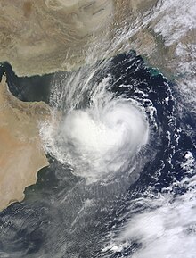
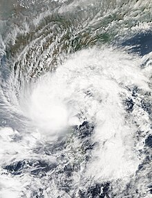
- 00:00 UTC (5:30 a.m. IST) at 13°42′N 64°18′E / 13.7°N 64.3°E / 13.7; 64.3 (Deep Depression ARB 04 (04A) intensifies into a cyclonic storm) – The IMD reports that Deep Depression ARB 04 (04A) has intensified into a cyclonic storm and names it "Chapala" while the system is located roughly 915 km (570 mi) west of Lakshadweep, India.[13]
- 09:00 UTC (2:30 p.m. IST) at 14°00′N 63°30′E / 14.0°N 63.5°E / 14.0; 63.5 (Cyclonic Storm Chapala (04A) intensifies into a severe cyclonic storm) – The IMD reports that Cyclonic Storm Chapala (04A) has intensified into a severe cyclonic storm while located roughly 870 km (540 mi) southeast of Duqm, Oman.[13]
- 12:00 UTC (5:30 p.m. IST) at 14°12′N 63°06′E / 14.2°N 63.1°E / 14.2; 63.1 (Tropical Storm Chapala (04A) intensifies into a category 1 tropical cyclone) – The JTWC reports that Tropical Storm Chapala (04A) has intensified into a category 1 tropical cyclone while located roughly 780 km (485 mi) southeast of Duqm, Oman.[16]
- 18:00 UTC (11:30 UTC) at 14°18′N 62°30′E / 14.3°N 62.5°E / 14.3; 62.5 (Severe Cyclonic Storm Chapala (04A) intensifies into a very severe cyclonic storm) – The IMD reports that Severe Cyclonic Storm Chapala (04A) has intensified into a very severe cyclonic storm while located roughly 775 km (480 mi) southeast of Duqm, Oman.[13]
30 October
- 00:00 UTC (5:30 a.m. IST) at 14°18′N 61°48′E / 14.3°N 61.8°E / 14.3; 61.8 (Very Severe Cyclonic Storm Chapala (04A) intensifies into an extremely severe cyclonic storm) – The IMD reports that Very Severe Cyclonic Storm Chapala (04A) has intensified into an extremely severe cyclonic storm while located roughly 730 km (455 mi) southeast of Duqm, Oman.[13]
- 00:00 UTC (5:30 a.m. IST) at 14°12′N 61°48′E / 14.2°N 61.8°E / 14.2; 61.8 (Tropical Cyclone Chapala (04A) intensifies into a category 3 tropical cyclone) – The JTWC reports that Tropical Cyclone Chapala (04A) has intensified into a category 3 tropical cyclone while located roughly 735 km (455 mi) southeast of Duqm, Oman.[16]
- 06:00 UTC (11:30 a.m. IST) at 14°06′N 61°06′E / 14.1°N 61.1°E / 14.1; 61.1 (Tropical Cyclone Chapala (04A) intensifies into a category 4 tropical cyclone) – The JTWC reports that Tropical Cyclone Chapala (04A) has intensified into a category 4 tropical cyclone while located roughly 695 km (430 mi) southeast of Duqm, Oman. Simultaneously, they report that the system has reached its peak intensity, with maximum 1-minute sustained wind speeds of 240 km/h (150 mph).[16]
- 09:00 UTC (2:30 p.m. IST) at 14°12′N 60°48′E / 14.2°N 60.8°E / 14.2; 60.8 (Extremely Severe Cyclonic Storm Chapala (04A) attains its peak winds) – The IMD reports that Extremely Severe Cyclonic Storm Chapala (04A) has reached its peak intensity, with maximum 3-minute sustained wind speeds of 210 km/h (130 mph), while located roughly 675 km (420 mi) southeast of Duqm, Oman.[13]
31 October
- 06:00 UTC (11:30 a.m. IST) at 13°48′N 58°42′E / 13.8°N 58.7°E / 13.8; 58.7 (Tropical Cyclone Chapala (04A) weakens into a category 3 tropical cyclone) – The JTWC reports that Tropical Cyclone Chapala (04A) has weakened into a category 3 tropical cyclone while located roughly 535 km (330 mi) east of the Yemeni island of Socotra.[16]
November

1 November
- 00:00 UTC (5:30 a.m. IST) at 13°36′N 56°24′E / 13.6°N 56.4°E / 13.6; 56.4 (Tropical Cyclone Chapala (04A) re-intensifies into a category 4 tropical cyclone) – The JTWC reports that Tropical Cyclone Chapala (04A) has re-intensified into a category 4 tropical cyclone while located roughly 290 km (180 mi) east of Socotra.[16]
- 18:00 UTC (11:30 p.m. IST) at 13°24′N 53°42′E / 13.4°N 53.7°E / 13.4; 53.7 (Extremely Severe Cyclonic Storm Chapala (04A) makes its closest approach to Socotra) – The IMD reports that Extremely Severe Cyclonic Storm Chapala (04A) has made its closest approach to Socotra, passing 90 km (55 mi) north of the island with maximum 3-minute sustained wind speeds of 185 km/h (115 mph).[13] This makes Chapala the first storm to produce hurricane-force winds on the island since 1922.[17]
2 November
- 00:00 UTC (5:30 a.m. IST) at 13°12′N 52°36′E / 13.2°N 52.6°E / 13.2; 52.6 (Tropical Cyclone Chapala (04A) weakens into a category 3 tropical cyclone) – The JTWC reports that Tropical Cyclone Chapala (04A) has weakened into a category 3 tropical cyclone while located roughly 155 km (95 mi) northeast of Socotra.[16]
- 12:00 UTC (5:30 p.m. IST) at 13°24′N 50°30′E / 13.4°N 50.5°E / 13.4; 50.5 (Extremely Severe Cyclonic Storm Chapala (04A) weakens into a very severe cyclonic storm) – The IMD reports that Extremely Severe Cyclonic Storm Chapala (04A) has weakened into a very severe cyclonic storm while located roughly 160 km (100 mi) north of Alula, Somalia.[13]
- 18:00 UTC (11:30 p.m. IST) at 13°42′N 49°36′E / 13.7°N 49.6°E / 13.7; 49.6 (Tropical Cyclone Chapala (04A) weakens into a category 2 tropical cyclone) – The JTWC reports that Tropical Cyclone Chapala (04A) has weakened into a category 2 tropical cyclone while located roughly 110 km (70 mi) south of Mukalla, Yemen.[16]
3 November
- 00:00 UTC (5:30 a.m. IST) at 14°00′N 48°54′E / 14.0°N 48.9°E / 14.0; 48.9 (Tropical Cyclone Chapala (04A) weakens into a category 1 tropical cyclone) – The JTWC reports that Tropical Cyclone Chapala (04A) has weakened into a category 1 tropical cyclone while located roughly 85 km (55 mi) southwest of Mukalla, Yemen.[16]
- 01:00–02:00 UTC (6:30–7:30 a.m. IST) at 14°06′N 48°42′E / 14.1°N 48.7°E / 14.1; 48.7 (Very Severe Cyclonic Storm Chapala (04A) makes landfall) – The IMD reports that Very Severe Cyclonic Storm Chapala (04A) has made landfall to the southwest of Mukalla, Yemen with maximum 3-minute sustained wind speeds of 120 km/h (75 mph).[13] This makes Chapala the first storm in recorded history to make landfall with hurricane-force winds on the Yemeni mainland.[8]
- 03:00 UTC (8:30 a.m. IST) at 14°12′N 48°24′E / 14.2°N 48.4°E / 14.2; 48.4 (Very Severe Cyclonic Storm Chapala (04A) weakens into a severe cyclonic storm) – The IMD reports that Very Severe Cyclonic Storm Chapala (04A) has weakened into a severe cyclonic storm while located roughly 110 km (70 mi) southwest of Mukalla, Yemen.[13]
- 03:00 UTC (8:30 a.m. IST) at 14°00′N 48°24′E / 14.0°N 48.4°E / 14.0; 48.4 (Tropical Cyclone Chapala (04A) weakens into a tropical storm) – The JTWC reports that Tropical Cyclone Chapala (04A) has weakened into a tropical storm while located roughly 120 km (75 mi) southwest of Mukalla, Yemen.[16]
- 06:00 UTC (11:30 a.m. IST) at 14°12′N 47°48′E / 14.2°N 47.8°E / 14.2; 47.8 (Severe Cyclonic Storm Chapala (04A) weakens into a cyclonic storm) – The IMD reports that Severe Cyclonic Storm Chapala (04A) has weakened into a cyclonic storm while located roughly 170 km (105 mi) west of Mukalla, Yemen.[13]
- 18:00 UTC (11:30 p.m. IST) at 14°18′N 47°00′E / 14.3°N 47.0°E / 14.3; 47.0 (Cyclonic Storm Chapala (04A) weakens into a deep depression) – The IMD reports that Cyclonic Storm Chapala (04A) has weakened into a deep depression while located roughly 35 km (20 mi) southeast of Ataq, Yemen.[13]
- 18:00 UTC (11:30 p.m. IST) at 14°18′N 47°24′E / 14.3°N 47.4°E / 14.3; 47.4 (Tropical Storm Chapala (04A) weakens into a tropical depression and dissipates) – The JTWC reports that Tropical Storm Chapala (04A) has weakened into a tropical depression and dissipated while located roughly 70 km (45 mi) southeast of Ataq, Yemen.[16]
4 November
- 00:00 UTC (5:30 a.m. IST) at 14°48′N 46°30′E / 14.8°N 46.5°E / 14.8; 46.5 (Deep Depression ex-Chapala (04A) weakens into a depression) – The IMD reports that Deep Depression ex-Chapala (04A) has weakened into a depression while located roughly 45 km (30 mi) northwest of Ataq, Yemen.[13]
- 03:00 UTC (8:30 a.m. IST) at 14°48′N 46°30′E / 14.8°N 46.5°E / 14.8; 46.5 (Depression ex-Chapala (04A) weakens into a well-marked area of low pressure) – The IMD reports that Depression ex-Chapala (04A) has weakened into a well-marked area of low pressure while located over Yemen.[13]
- 18:00 UTC (11:30 p.m. IST) at 14°00′N 66°24′E / 14.0°N 66.4°E / 14.0; 66.4 (Tropical Depression 05A forms from an area of low pressure) – The JTWC reports that Tropical Depression 05A has formed from an area of low pressure while located roughly 720 km (445 mi) northwest of Lakshadweep, India.[18]

5 November
- 00:00 UTC at 14°06′N 66°00′E / 14.1°N 66.0°E / 14.1; 66.0 (Depression ARB 05 (05A) forms from an area of low pressure) – The IMD designates Tropical Depression 05A as Depression ARB 05 while the system is located roughly 765 km (475 mi) northwest of Lakshadweep, India.[13]
- 06:00 UTC at 14°06′N 64°48′E / 14.1°N 64.8°E / 14.1; 64.8 (Depression ARB 05 (05A) intensifies into a deep depression) – The IMD reports that Depression ARB 05 (05A) has intensified into a deep depression while located roughly 880 km (545 mi) northwest of Lakshadweep, India.[13]
- 06:00 UTC at 14°00′N 64°48′E / 14.0°N 64.8°E / 14.0; 64.8 (Tropical Depression ARB 05 (05A) intensifies into a tropical storm) – The JTWC reports that Tropical Depression ARB 05 (05A) has intensified into a tropical storm while located roughly 875 km (545 mi) northwest of Lakshadweep, India.[18]
- 12:00 UTC at 14°00′N 64°00′E / 14.0°N 64.0°E / 14.0; 64.0 (Deep Depression ARB 05 (05A) intensifies into a cyclonic storm) – The IMD reports that Deep Depression ARB 05 (05A) has intensified into a cyclonic storm and names it "Megh" while the system is located roughly 910 km (565 mi) southeast of Duqm, Oman.[13]
7 November
- 06:00 UTC (11:30 a.m. IST) at 12°42′N 59°12′E / 12.7°N 59.2°E / 12.7; 59.2 (Cyclonic Storm Megh (05A) intensifies into a severe cyclonic storm) – The IMD reports that Cyclonic Storm Megh (05A) has intensified into a severe cyclonic storm while located roughly 575 km (355 mi) east of Socotra.[13]
- 06:00 UTC (11:30 a.m. IST) at 12°42′N 59°18′E / 12.7°N 59.3°E / 12.7; 59.3 (Tropical Storm Megh (05A) intensifies into a category 1 tropical cyclone) – The JTWC reports that Tropical Storm Megh (05A) has intensified into a category 1 tropical cyclone while located roughly 585 km (365 mi) east of Socotra.[18]
- 15:00 UTC (8:30 p.m. IST) at 12°36′N 57°54′E / 12.6°N 57.9°E / 12.6; 57.9 (Severe Cyclonic Storm Megh (05A) intensifies into a very severe cyclonic storm) – The IMD reports that Severe Cyclonic Storm Megh (05A) has intensified into a very severe cyclonic storm while located roughly 435 km (270 mi) east of Socotra.[13]
- 18:00 UTC (11:30 p.m. IST) at 12°48′N 57°18′E / 12.8°N 57.3°E / 12.8; 57.3 (Tropical Cyclone Megh (05A) intensifies into a category 2 tropical cyclone) – The JTWC reports that Tropical Cyclone Megh (05A) has intensified into a category 2 tropical cyclone while located roughly 370 km (230 mi) east of Socotra.[18]

8 November
- 00:00 UTC (5:30 a.m. IST) at 12°42′N 56°06′E / 12.7°N 56.1°E / 12.7; 56.1 (Tropical Cyclone Megh (05A) intensifies into a category 3 tropical cyclone) – The JTWC reports that Tropical Cyclone Megh (05A) has intensified into a category 3 tropical cyclone while located roughly 240 km (150 mi) east of Socotra.[18]
- 03:00 UTC (8:30 a.m. IST) at 12°42′N 55°30′E / 12.7°N 55.5°E / 12.7; 55.5 (Very Severe Cyclonic Storm Megh (05A) intensifies into an extremely severe cyclonic storm) – The IMD reports that Very Severe Cyclonic Storm Megh (05A) has intensified into an extremely severe cyclonic storm while located roughly 175 km (110 mi) east of Socotra.[13]
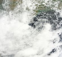
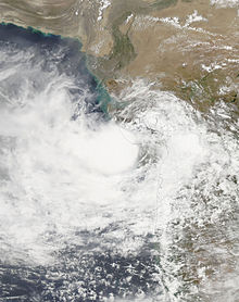
- 03:00 UTC (8:30 a.m. IST) at 10°42′N 83°42′E / 10.7°N 83.7°E / 10.7; 83.7 (Depression BOB 03 forms from an area of low pressure) – The IMD reports that Depression BOB 03 has formed from an area of low pressure while located roughly 360 km (225 mi) northeast of Trincomalee, Sri Lanka.[13]
- 06:00 UTC (11:30 a.m. IST) at 12°42′N 54°54′E / 12.7°N 54.9°E / 12.7; 54.9 (Extremely Severe Cyclonic Storm Megh (05A) reaches its peak intensity) – The IMD reports that Extremely Severe Cyclonic Storm Megh (05A) has reached its peak intensity, with 3-minute sustained wind speeds of 175 km/h (110 mph), while located roughly 110 km (70 mi) east of Socotra.[13]
- 06:00 UTC (11:30 a.m. IST) at 12°36′N 54°54′E / 12.6°N 54.9°E / 12.6; 54.9 (Tropical Cyclone Megh (05A) attains its peak winds) – The JTWC reports that Tropical Cyclone Megh (05A) has reached its peak intensity, with maximum 1-minute wind speeds of 200 km/h (125 mph), while located roughly 110 km (70 mi) east of Socotra.[18]
- 06:00–12:00 UTC (11:30 a.m.–5:30 p.m. IST) at 12°42′N 54°12′E / 12.7°N 54.2°E / 12.7; 54.2 (Extremely Severe Cyclonic Storm Megh (05A) makes landfall) – The IMD reports that Extremely Severe Tropical Cyclone Megh has made landfall on the northern coast of Socotra with maximum 3-minute sustained wind speeds of 175 km/h (110 mph).[13]
- 12:00 UTC (5:30 p.m. IST) at 12°36′N 53°30′E / 12.6°N 53.5°E / 12.6; 53.5 (Tropical Cyclone Megh (05A) weakens into a category 2 tropical cyclone) – The JTWC reports that Tropical Cyclone Megh (05A) has weakened into a category 2 tropical cyclone while located roughly 45 km (30 mi) west of Socotra.[18]
- 18:00 UTC (11:30 p.m. IST) at 11°12′N 81°24′E / 11.2°N 81.4°E / 11.2; 81.4 (Depression BOB 03 intensifies into a deep depression) – The IMD reports that Depression BOB 03 has intensified into a deep depression while located roughly 195 km (120 mi) southeast of Pondicherry, Puducherry. Simultaneously, they report that the storm has reached its peak intensity, with maximum 3-minute sustained wind speeds of 55 km/h (35 mph).[13]
- 18:00 UTC (11:30 p.m. IST) at 12°24′N 52°06′E / 12.4°N 52.1°E / 12.4; 52.1 (Tropical Cyclone Megh (05A) weakens into a category 1 tropical cyclone) – The JTWC reports that Tropical Cyclone Megh (05A) has weakened into a category 1 tropical cyclone while located roughly 155 km (95 mi) east of Alula, Somalia.[18]
9 November
- 00:00 UTC (5:30 a.m. IST) at 12°18′N 51°00′E / 12.3°N 51.0°E / 12.3; 51.0 (Extremely Severe Cyclonic Storm Megh (05A) weakens into a very severe cyclonic storm) – The IMD reports that Extremely Severe Cyclonic Storm Megh (05A) has made its closest approach to the Somali coast, passing roughly 45 km (30 mi) northeast of Alula, Somalia as it weakens into a very severe cyclonic storm.[13]
- 06:00 UTC (11:30 a.m IST) at 12°12′N 49°30′E / 12.2°N 49.5°E / 12.2; 49.5 (Tropical Cyclone Megh (05A) weakens into a tropical storm) – The JTWC reports that Tropical Cyclone Megh (05A) has weakened into a tropical storm while located roughly 140 km (85 mi) west of Alula, Somalia.[18]
- 14:00 UTC (7:30 p.m. IST) at 12°12′N 80°00′E / 12.2°N 80.0°E / 12.2; 80.0 (Deep Depression BOB 03 makes landfall) – The IMD reports that Deep Depression BOB 03 has made landfall near Marakkanam, Tamil Nadu with maximum 3-minute sustained wind speeds of 55 km/h (35 mph).[13]
- 21:00 UTC (2:30 a.m. IST, 10 November) at 12°42′N 46°48′E / 12.7°N 46.8°E / 12.7; 46.8 (Very Severe Cyclonic Storm Megh (05A) weakens into a severe cyclonic storm) – The IMD reports that Very Severe Cyclonic Storm Megh (05A) has weakened into a severe cyclonic storm while located roughly 200 km (125 mi) east of Aden, Yemen.[13]
10 November
- 00:00 UTC (5:30 a.m. IST) at 12°48′N 47°36′E / 12.8°N 47.6°E / 12.8; 47.6 (Tropical Storm Megh (05A) weakens into a tropical depression) – The JTWC reports that Tropical Storm Megh (05A) has weakened into a tropical depression while located roughly 210 km (130 mi) southeast of Ataq, Yemen.[18]
- 03:00 UTC (8:30 a.m. IST) at 13°06′N 46°12′E / 13.1°N 46.2°E / 13.1; 46.2 (Severe Cyclonic Storm Megh (05A) weakens into a cyclonic storm) – The IMD reports that Severe Cyclonic Storm Megh (05A) has weakened into a cyclonic storm while located roughly 130 km (80 mi) east of Aden, Yemen.[13]
- 03:00 UTC (8:30 a.m. IST) at 12°24′N 79°18′E / 12.4°N 79.3°E / 12.4; 79.3 (Deep Depression BOB 03 weakens into a depression) – The IMD reports that Deep Depression BOB 03 has weakened into a depression while located roughly 75 km (45 mi) northwest of Pondicherry, Puducherry.[13]
- 06:00 UTC (11:30 a.m. IST) at 13°18′N 46°06′E / 13.3°N 46.1°E / 13.3; 46.1 (Cyclonic Storm Megh (05A) weakens into a deep depression) – The IMD reports that Cyclonic Storm Megh (05A) has weakened into a deep depression while located roughly 125 km (80 mi) east of Aden, Yemen.[13]
- 06:00 UTC (11:30 a.m. IST) at 12°24′N 79°18′E / 12.4°N 79.3°E / 12.4; 79.3 (Depression BOB 03 weakens into a well-marked low-pressure area) – The IMD reports that Depression BOB 03 has weakened into a well-marked low-pressure area while located over northern Tamil Nadu.[13]
- 09:00 UTC (2:30 p.m. IST) at 13°24′N 46°06′E / 13.4°N 46.1°E / 13.4; 46.1 (Deep Depression ex-Megh (05A) makes landfall) – The IMD reports that Deep Depression ex-Megh (05A) has made landfall on the Yemeni mainland 60 km (35 mi) southeast of Lawdar with maximum 3-minute sustained wind speeds of 55 km/h (35 mph).[13]
- 12:00 UTC (5:30 p.m. IST) at 13°36′N 46°30′E / 13.6°N 46.5°E / 13.6; 46.5 (Deep Depression ex-Megh (05A) weakens into a depression) - The IMD reports that Deep Depression ex-Megh (05A) has weakened into a depression while located roughly 85 km (55 mi) southeast of Lawdar, Yemen.[13]
- 12:00 UTC (5:30 p.m. IST) at 13°42′N 46°42′E / 13.7°N 46.7°E / 13.7; 46.7 (Tropical Depression Megh (05A) weakens into an area of low pressure and dissipates) – The JTWC reports that Tropical Depression Megh (05A) has weakened into an area of low pressure and dissipated while located roughly 90 km (55 mi) east of Lawdar, Yemen.[18]
- 18:00 UTC (11:30 p.m. IST) at 13°36′N 46°30′E / 13.6°N 46.5°E / 13.6; 46.5 (Depression ex-Megh (05A) weakens into a well-marked low-pressure area) – The IMD reports that Depression ex-Megh (05A) has weakened into a well-marked low-pressure area over Yemen.[13]
See also
- Timeline of the 2015 Atlantic hurricane season
- Timeline of the 2015 Pacific hurricane season
- Timeline of the 2015 Pacific typhoon season
Footnotes
- ^ According to the India Meteorological Department, an average of five tropical cyclones of at least cyclonic storm intensity form in the North Indian Ocean annually; the 2015 season featured only four such storms.[1]
- ^ UTC stands for Coordinated Universal Time.
- ^ IST stands for Indian Standard Time, which is equivalent to UTC+5:30.
- ^ The figures for maximum sustained winds and position estimates are rounded to the nearest 5 units (knots, miles, or kilometers), following the convention used in the India Meteorological Department and Joint Typhoon Warning Center's operational products for each storm. All other units are rounded to the nearest digit.
References
- ^ a b Report on Cyclonic Disturbances Over North Indian Ocean During 2015 (PDF) (Report). New Delhi, India: India Meteorological Department. April 2016. p. 18. Archived (PDF) from the original on 26 October 2020. Retrieved 18 June 2017.
- ^ Eric Leister (12 June 2015). "Rainstorm Ashobaa Slams Oman With Historic Flooding". Accuweather. Archived from the original on 28 July 2017. Retrieved 18 June 2017.
- ^ Fahad Al Mukrashi (12 June 2015). "Heavy rains cause flooding in southern Oman". Gulf News. Muscat, Oman. Archived from the original on 28 July 2017. Retrieved 18 June 2017.
- ^ Bindu Rai. "Ashobaa Latest: Gale winds to strike Muscat; Waterlogging in Fujairah". Emirates247. Archived from the original on 2015-06-13. Retrieved 18 June 2017.
- ^ "Gujarat's Amreli battles worst flood in 90 years". Times of India. Rajkot, India. 26 June 2015. Archived from the original on 7 August 2017. Retrieved 18 June 2017.
- ^ "Gujarat death toll touches 80, four lakh ex gratia for kin". Hindustan Times. Ahmedabad, India. 27 June 2015. Archived from the original on 15 August 2015. Retrieved 18 June 2017.
- ^ "Flash flood: Govt announces Rs 300-crore relief package". The Indian Express. 15 July 2015. Archived from the original on 28 July 2017. Retrieved 18 June 2017.
- ^ a b Bob Henson (3 November 2015). "Chapala Slams Yemen: First Hurricane-Strength Cyclone on Record". Weather Underground. Archived from the original on 30 March 2020. Retrieved 17 June 2017.
- ^ Jason Samenow (9 November 2015). "Unprecedented: Second freak tropical cyclone to strike Yemen in the same week". The Washington Post. Archived from the original on 11 October 2018. Retrieved 18 June 2017.
- ^ "Rain batters TN: Jaya announces Rs 500cr relief, IAF in action". Hindustan Times. 16 November 2015. Archived from the original on 28 July 2017. Retrieved 18 June 2017.
- ^ "31 people killed in Tamil Nadu in rain related incidents". The Statesman. Press Trust of India. 12 November 2015. Archived from the original on 17 November 2015. Retrieved 18 June 2017.
- ^ a b c d "Best Track Data for Tropical Storm Ashobaa (01A)". International Best Track Archive for Climate Stewardship (IBTrACS). National Oceanic and Atmospheric Administration. Retrieved 18 June 2017.
- ^ a b c d e f g h i j k l m n o p q r s t u v w x y z aa ab ac ad ae af ag ah ai aj ak al am an ao ap aq ar as at au av aw ax ay az ba bb bc bd be bf bg bh bi bj bk bl bm bn bo bp bq br bs bt bu bv "Best Track Data for Tropical Cyclones (1990-2016)". India Meteorological Department. Archived from the original on 23 December 2017. Retrieved 17 June 2017.
- ^ a b c d "Best Track Data for Tropical Storm Komen (02B)". International Best Track Archive for Climate Stewardship (IBTrACS). National Oceanic and Atmospheric Administration. Retrieved 18 June 2017.
- ^ a b c d "Best Track Data for Tropical Storm ARB 03 (03A)". International Best Track Archive for Climate Stewardship (IBTrACS). National Oceanic and Atmospheric Administration. Retrieved 18 June 2017.
- ^ a b c d e f g h i j k l "Best Track Data for Tropical Cyclone Chapala (04A)". International Best Track Archive for Climate Stewardship (IBTrACS). National Oceanic and Atmospheric Administration. Retrieved 18 June 2017.
- ^ Derek Baldwin (2 November 2015). "Cyclone Chapala to dump 400mm of rainfall in Yemen". Gulf News. Dubai, United Arab Emirates. Archived from the original on 26 April 2020. Retrieved 18 June 2017.
- ^ a b c d e f g h i j k "Best Track Data for Tropical Cyclone Megh (05A)". International Best Track Archive for Climate Stewardship (IBTrACS). National Oceanic and Atmospheric Administration. Retrieved 18 June 2017.


