Thomas Mill Covered Bridge
United States historic place
Thomas Mill Covered Bridge | |
U.S. Historic district Contributing property | |
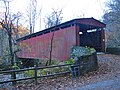
 Thomas Mill Covered Bridge in 1972 | |
40°04′19″N 75°13′32″W / 40.07187°N 75.22559°W / 40.07187; -75.22559 | |
| Built | 1855 |
|---|---|
| MPS | Covered Bridges of the Delaware River Watershed TR |
| NRHP reference No. | 80003621[1] |
| Added to NRHP | December 1, 1980 |
The Thomas Mill Covered Bridge, aka the Thomas Mill Bridge or the Thomas Mill Road Covered Bridge, is a historic, single-span, wooden covered bridge across the Wissahickon Creek in Wissahickon Valley Park in Northwest Philadelphia, Pennsylvania.
The only remaining covered bridge in Philadelphia and the only covered bridge in a major American city, it was listed on the National Register of Historic Places in 1980.
History and architectural features
This 86.5-foot-long (26.4 m), 18.66-foot-wide (5.69 m), Howe truss bridge was built in 1855. It was renovated by the Works Progress Administration in 1939, and by the city of Philadelphia in 2000.[2]
It is the only remaining covered bridge in Philadelphia and is the only covered bridge in a major US city. It was listed on the National Register of Historic Places in 1980. It is a Contributing Property of the Chestnut Hill Historic District.
The bridge is open to pedestrian and bicycle traffic.
Gallery
-
 Bridge in 2010
 -
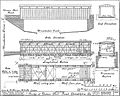 HABS drawing


References
 Philadelphia portal

- ^ "National Register Information System". National Register of Historic Places. National Park Service. July 9, 2010.
- ^ "Bridges". Friends of the Wissahickon. Archived from the original on January 4, 2014. Retrieved January 4, 2014.
External links
 Media related to Thomas Mill Covered Bridge at Wikimedia Commons
- Historic American Buildings Survey (HABS) No. PA-19, "Covered Bridge, Thomas Mill Road (Spanning Wissahickon Creek), Philadelphia, Philadelphia County, PA", 2 photos, 1 color transparency, 2 measured drawings, 2 photo caption pages
- Article at Drexel University
- "A Bridge Too Old", by Amy Choi, Philadelphia Citypaper, August 27–September 3, 1998
- Thomas Mill Covered Bridge data from the Philadelphia Architects and Buildings (PAB) project of the Athenaeum of Philadelphia
- Listing and photographs at BridgeHunter.com
- Wood, Stone, and Steel: Bridges in the Wissahickon, Friends of the Wissahickon
- v
- t
- e

- Adams
- Allegheny
- Armstrong
- Beaver
- Bedford
- Berks
- Blair
- Bradford
- Bucks
- Butler
- Cambria
- Cameron
- Carbon
- Centre
- Chester
- Clarion
- Clearfield
- Clinton
- Columbia
- Crawford
- Cumberland
- Dauphin
- Delaware
- Elk
- Erie
- Fayette
- Forest
- Franklin
- Fulton
- Greene
- Huntingdon
- Indiana
- Jefferson
- Juniata
- Lackawanna
- Lancaster
- Lawrence
- Lebanon
- Lehigh
- Luzerne
- Lycoming
- McKean
- Mercer
- Mifflin
- Monroe
- Montgomery
- Montour
- Northampton
- Northumberland
- Perry
- Philadelphia
- Pike
- Potter
- Schuylkill
- Snyder
- Somerset
- Sullivan
- Susquehanna
- Tioga
- Union
- Venango
- Warren
- Washington
- Wayne
- Westmoreland
- Wyoming
- York
 Category
 NRHP portal


