State Road 13 (Serbia)
Road in Serbia
 | ||||
|---|---|---|---|---|
| Serbian: Državni put IB reda 13 Serbian Cyrillic: Државни пут IБ реда 13 | ||||
 | ||||
| Route information | ||||
| Maintained by JP "Putevi Srbije" | ||||
| Length | 194.761 km (121.019 mi) | |||
| Major junctions | ||||
| From | Horgoš   E75 E75 | |||
| Major intersections |
| |||
| To | Belgrade    E70 E70 | |||
| Location | ||||
| Country | Serbia | |||
| Districts | North Banat, Central Banat, City of Belgrade | |||
| Highway system | ||||
| ||||


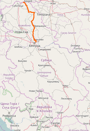
State Road 13, is an IB-class road, located in northern Serbia, connecting Horgoš with Belgrade. It is located in Vojvodina and City of Belgrade.[1]
Before the new road categorization regulation given in 2013, the route wore the following names: O 10, M 22.1, P 119, P 111, P 112, M 24, M 3 and M 24.1 (before 2012) / 102, 11, and 104 (after 2012).[2][3]
The existing route is a main road with two traffic lanes, except for Kovilovo interchange – Belgrade (printing company) section, which has been done in dual-carriageway six-lane configuration. By the valid Space Plan of Republic of Serbia the road is not planned for upgrading to motorway, and is expected to be conditioned in its current state.[4]
Sections
| Section number | Length | Distance | Section name |
|---|---|---|---|
| 01301 | 0.796 km (0.495 mi) | 0.796 km (0.495 mi) | Horgoš interchange – Horgoš () |
| 01302 | 0.230 km (0.143 mi) | 1.026 km (0.638 mi) | Horgoš () – Horgoš (Kanjiža) (overlap with  ) ) |
| 01303 | 11.956 km (7.429 mi) | 12.982 km (8.067 mi) | Horgoš (Kanjiža) – Kanjiža |
| 01304 | 7.080 km (4.399 mi) | 20.062 km (12.466 mi) | Kanjiža – Novi Kneževac (Đala) |
| 01305 | 12.444 km (7.732 mi) | 32.506 km (20.198 mi) | Novi Kneževac (Đala) – Čoka (Crna Bara) |
| 01306 | 12.444 km (7.732 mi) | 32.883 km (20.433 mi) | Čoka (Crna Bara) – Čoka (Senta) (overlap with  ) ) |
| 01307 | 34.906 km (21.690 mi)/0.129 km (0.080 mi) | 67.789 km (42.122 mi) | Čoka (Senta) – Kikinda (Nakovo) |
| 01308 | 3.132 km (1.946 mi) | 70.921 km (44.068 mi) | Kikinda (Nakovo) – Kikinda (Novi Bečej) (overlap with  ) ) |
| 01309 | 19.577 km (12.165 mi) | 90.498 km (56.233 mi) | Kikinda (Novi Bečej) – Bašaid (Novi Bečej) |
| 01310 | 15.999 km (9.941 mi) | 106.497 km (66.174 mi) | Bašaid (Novi Bečej) – Melenci |
| 01311 | 15.704 km (9.758 mi) | 122.201 km (75.932 mi) | Melenci – Zrenjanin (Kikinda) |
| 01217 | 1.662 km (1.033 mi) | 123.863 km (76.965 mi) | Zrenjanin (Kikinda) – Zrenjanin (Ečka) (overlap with  ) ) |
| 01312 | 8.629 km (5.362 mi)/0.083 km (0.052 mi) | 132.492 km (82.327 mi) | Zrenjanin (Ečka) – Ečka |
| 01313 | 12.347 km (7.672 mi) | 144.839 km (89.999 mi) | Ečka – Perlez (Titel) |
| 01314 | 2.487 km (1.545 mi) | 147.326 km (91.544 mi) | Perlez (Titel) – Perlez (Kovačica) (overlap with  ) ) |
| 01315 | 9.694 km (6.024 mi) | 157.020 km (97.568 mi) | Perlez (Kovačica) – Čenta |
| 01316 | 2.828 km (1.757 mi) | 159.848 km (99.325 mi) | Čenta – Vojvodina border (Belgrade – Čenta) |
| 01317 | 22.678 km (14.091 mi) | 182.526 km (113.416 mi) | Vojvodina border (Belgrade – Čenta) – Kovilovo interchange |
| 01318/01319 | 12.235 km (7.602 mi) (both directions) | 194.761 km (121.019 mi) | Kovilovo interchange – Belgrade (printing company) |
See also
References
- ^ "Republic of Serbia – national road network" (PDF). Putevi Srbije (in Serbian).
- ^ "National road categorization regulation – Official Gazette of Republic of Serbia no. 105/2013 and 119/2013" (PDF). Serbian Spatial Planners Association (in Serbian).
- ^ "Link between actual and previous section and road markings" (PDF). Putevi Srbije (in Serbian).
- ^ Space plan of Republic of Serbia from 2010 to 2021
External links
- Official website – Roads of Serbia (Putevi Srbije)
- Official website – Corridors of Serbia (Koridori Srbije) (Serbian)
- v
- t
- e
državni put IA reda, pl. državni putevi IA reda)
- А1
- А2
- А3
- А4
- А5
- Belgrade bypass
- Expressway 10
- Expressway 24
- Expressway 47
- 10
- 11
- 12
- 13
- 14
- 15
- 16
- 17
- 18
- 19
- 20
- 21
- 22
- 23
- 24
- 25
- 26
- 27
- 28
- 29
- 30
- 31
- 32
- 33
- 34
- 35
- 36
- 37
- 38
- 39
- 40
- 41
- 42
- 45
- 46
- 47
- 100
- 101
- 102
- 103
- 104
- 105
- 106
- 107
- 108
- 109
- 110
- 111
- 112
- 113
- 114
- 115
- 116
- 117
- 118
- 119
- 120
- 121
- 122
- 123
- 124
- 125
- 126
- 127
- 128
- 129
- 130
- 131


