Shearer's Covered Bridge
Bridge in Pennsylvania, United States
40°10′17″N 76°23′23″W / 40.1715°N 76.3898°W / 40.1715; -76.3898
The Shearer's Covered Bridge is a covered bridge that spans the Big Chiques Creek in Lancaster County, Pennsylvania, United States. (Chiques Creek was known as Chickies Creek until 2002).[1]
The bridge has a single span, wooden, double Burr arch trusses design. It is the only covered bridge in the county painted entirely in red, the traditional color of Lancaster County covered bridges, on both the inside and outside including both approaches. The other all red bridge, Pool Forge Covered Bridge, is only painted on the outside. It is one of only 3 covered bridges in the county with horizontal side boards.
The bridge's WGCB Number is 38-36-31. Added in 1980, it is listed on the National Register of Historic Places as structure number 80003532.[2] It is located at 40°10′17.4″N 76°23′23.4″W / 40.171500°N 76.389833°W / 40.171500; -76.389833 (40.17150, -76.38983).[3]
History
The bridge was built in 1847 by Jacob Clare. It was rebuilt in 1855 and stayed there until it was moved in 1971 to its present location in the Manheim Memorial Park. It is 89 feet long and it's also the only covered bridge that does not allow motor vehicles.
Dimensions
- Length: 86 feet (26.2 m) total length
- Width: 15 feet (4.6 m) total width
- Overhead clearance: 11 feet 6 inches (3.51 m)
Gallery
-
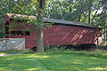 View of the bridge from the side
 -
 Three quarters view
 -
 One of the approaches to the bridge
 -
 An inside view of the bridge
 -
 A closeup of the Burr arch truss
 -
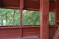 One of the bridge's window
 -
 The bridge's floor boards
 -
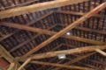 The bridge's ceiling
 -
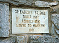 History plaque on the bridge
 -
 Approach view from the air
 -
 Side view from the air
 -
 View from the air towards Manheim Central High School


See also
- Burr arch truss
- List of Lancaster County covered bridges
References
- Bickel, Hank (2005-06-23). "Shearer Bridge". Covered Bridges of the Northeast USA. Retrieved 2006-08-04.
- McCain, Dr. Roger A. "Shearer's Bridge". A Guide to Old Covered Bridges of Southeastern Pennsylvania and nearby areas. Retrieved 2006-08-04.
- "Shearer's Mill Covered Bridge". Lancaster County Pennsylvania Dutch Country Official Visitors Center. Pennsylvania Dutch Convention & Visitors Bureau. 2006. Retrieved 2006-07-07.
- "The Covered Bridges of Lancaster County". Lancaster County, PA Government Portal. County of Lancaster, Pennsylvania. 2001-11-09. Archived from the original on 2005-12-26. Retrieved 2006-07-07.
- ^ Geographic Names Information System, United States Geological Survey (August 30, 1990). "Geographic Names Information System Feature Detail Report: Chiques Creek". Retrieved 2006-09-05.
- ^ "PENNSYLVANIA - Lancaster County". National Register of Historic Places. Retrieved 2007-03-20.
- ^ Travis, Dale. "38-36-31". Round Barns & Covered Bridges. Retrieved 2006-08-08.
Wikimedia Commons has media related to Shearer's Covered Bridge.
- v
- t
- e
- Contributing property
- Keeper of the Register
- Historic district
- History of the National Register of Historic Places
- National Park Service
- Property types

- Adams
- Allegheny
- Armstrong
- Beaver
- Bedford
- Berks
- Blair
- Bradford
- Bucks
- Butler
- Cambria
- Cameron
- Carbon
- Centre
- Chester
- Clarion
- Clearfield
- Clinton
- Columbia
- Crawford
- Cumberland
- Dauphin
- Delaware
- Elk
- Erie
- Fayette
- Forest
- Franklin
- Fulton
- Greene
- Huntingdon
- Indiana
- Jefferson
- Juniata
- Lackawanna
- Lancaster
- Lawrence
- Lebanon
- Lehigh
- Luzerne
- Lycoming
- McKean
- Mercer
- Mifflin
- Monroe
- Montgomery
- Montour
- Northampton
- Northumberland
- Perry
- Philadelphia
- Pike
- Potter
- Schuylkill
- Snyder
- Somerset
- Sullivan
- Susquehanna
- Tioga
- Union
- Venango
- Warren
- Washington
- Wayne
- Westmoreland
- Wyoming
- York
 Category
 NRHP portal


