Sgiath Chùil
56°27′9.94″N 4°29′46.64″W / 56.4527611°N 4.4962889°W / 56.4527611; -4.4962889
| Name | Grid ref | Height | Status |
|---|---|---|---|
| Meall a' Churain | NN463325 | 918 metres (3,012 ft) | Munro Top |
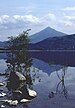
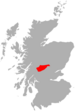
Sgiath Chùil is a mountain situated in the southern highlands of Scotland. It stands within Loch Lomond and the Trossachs National Park, on its northern border. It is about 11 kilometres (6.8 mi) west of Killin.
Description
Sgiath Chùil qualifies as a Munro, at a height of 921 metres (3,022 ft), and with prominence of 312 metres (1,024 ft), as a Marilyn. In Sir Hugh Munro's original list of peaks in Scotland with a height over 3,000 feet (914 m) that was published in the Scottish Mountaineering Club Journal in September 1891, Sgiath Chùil was listed as a top, with Meall a' Churain listed as the mountain and higher point. This error was corrected when the first revision of the list was published in 1921.[3]
References
- v
- t
- e
Munros of Scotland: Loch Rannoch to Loch Tay
- An Stùc
- Beinn Achaladair
- Beinn Challuim
- Beinn a' Chreachain
- Beinn Dòrain
- Beinn an Dòthaidh
- Beinn Ghlas
- Beinn Heasgarnich
- Ben Lawers
- Beinn Mhanach
- Càrn Gorm
- Càrn Mairg
- Creag Mhòr
- Meall Corranaich
- Meall nan Aighean
- Meall Buidhe
- Meall a' Choire Leith
- Meall Ghaordaidh
- Meall Garbh (Càrn Mairg Group)
- Meall Garbh (Lawers Group)
- Meall Glas
- Meall Greigh
- Meall nan Tarmachan
- Schiehallion
- Sgiath Chùil
- Stuchd an Lochain